East Crazy Mountain Land Exchange

EA just came out so we can now evaluate what is in it.

Maybe John can explain why he posted before anyone knew what was in it. That sort of timing it is a tactic by some in that group to set the narrative before the facts get established, but maybe that wasn't his purpose.

Link to EA ( I haven’t had time to review)
Maybe you can explain why you created this thread before anyone knew what was in it...

Wouldn't it be ridiculous if I were serious? Coincidence, Rob, not conspiracy.
 
A fair point about my style, which is counterproductive, but seriously, NEPA for trails that have been in use for a couple years? Still claiming the FS believes the trail is "public" even though the FS is no longer pushing that view? (BTW, public is actually 100% the wrong term in the correct definition of the status even if it has a prescriptive easement, and John should know that by now.) Still citing an outdated FS opinion even though the relevance of it was shot down in court? I'm just calling it as it is.

Maybe John can tell us why BHA is appealing their lawsuit based on NEPA for new trails that have already been in use for several years. NEPA, seriously. How is that solution orientated?
NEPA law is clear and it is certainly applicable in this case.

Show us the documents where the USFS changes their positions on these trails. I can provide a lot of evidence that they have not made a discrete decision to change their position.

I think you misunderstand our lawsuit and what happened in court. Either way, Judge Waters affirmed what I wrote above.

The law of prescriptive easement is well established and carries the same legal weight as any other easement. I think this may a good place to quote Supervisor Erickson again: “Thank you for your inquiry concerning Trail #136 in the Crazy Mountains. The Forest Service is aware of this illegally-blocked access point… The southern portion of Trail 136 provides one of the few access points to east side of the Crazy Mountains. It is a historic trail that dates back a century or more. The Forest Service maintains that it holds unperfected prescriptive rights on this trail system as well as up Sweet Grass Creek to the North based on a history of maintenance with public funds and historic and administrative public use.” When she says the "the Forest Service maintains that it holds unperfected prescriptive rights on this trail" she means the public holds unperfected prescriptive rights on this trail. Describing these trails a legal and public is accurate and appropriate.
 
Rob

I'm sorry you did not understand the analogy about the damn. I did make clear it was not a parallel analogy.

"The Sweet Grass was purposely left unresolved so that if people want to resolve it, they can do so at any time." Purposely unresolved is the problem. The USFS still considers that trail to be public. \
John - do us all a favor and ask one of PLWA's access lawyers to explain to you the difference between a public trail and a contested trail.

"It would also likely get passed anyway by the alternate route of Congress, and you can bet it will be a lot worse if it does that." Do you have any proof? Again, this sounds like the Yellowstone Club and their hired-guns threatening the public: Give us what we want or we will circumvent the public process and do whatever we want, and it will be a lot worse.
That legislative option is well known by people working on this. I was told it was the landowner's preferred option, but they will try going through the USFS process first. The legislative option was mentioned in point 4 of MWF's letter that you posted. In the initial comments solicited, MWF, or maybe just Salazar, commented that this should go through the administrative process, not the legislative process, because the public will have little to say about what happens if it goes through Congress.

From the MWF letter:
1668144827344.png
 
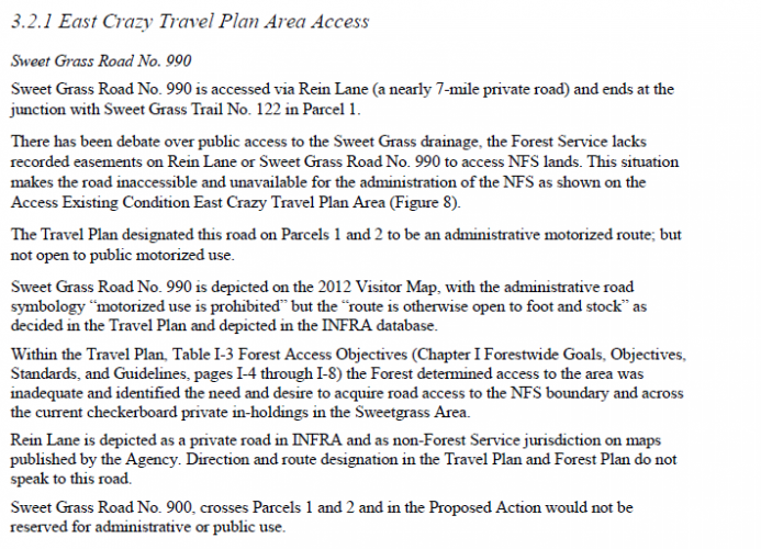
This is from page 27 of the EA I linked to earlier.

1668145282581.png


The second to last paragraph states INFRA depicts Rein Lane as private. I had to look up INFRA and it was described as "the USFS authoritative database for manmade features." (search for INFRA here https://data.fs.usda.gov/geodata/edw/datasets.php)

This is a key point that I have brought up several times: even if Sweet Grass trail was made public as Sullivan wants, access would still be blocked by Rein Lane.
 
John - do us all a favor and ask one of PLWA's access lawyers to explain to you the difference between a public trail and a contested trail.
I did. After a lot of research PLWA remains opposed.

https://static1.squarespace.com/sta...5972927/PLWA+Crazies+Letter+November+2022.pdf

"We agree that addressing critical issues through creation of the East Trunk Trail would be favorable, especially if they involve plans to grant permanent public easements. However, we strongly feel that without addressing access issues in the Sweetgrass Drainage, the required due diligence for the proposal remains absent, and we cannot offer our support.

PLWA appreciates the need for compromise and flexibility in public access work, however it remains our position that the Sweetgrass Trail is a vital public access point and that the road which has historically provided access through the drainage, specifically in Sections 7, 8, and 10 to the border of the National Forest, must be included in all evaluations and planning protocols. The current proposal fails to address a significant area which has historically provided public access and cedes it without comment into private hands. The current proposal offers access that is inferior to what has previously been enjoyed and available to the public, and as such there remains more work to be done."
 
[I was typing at the same time John was.]

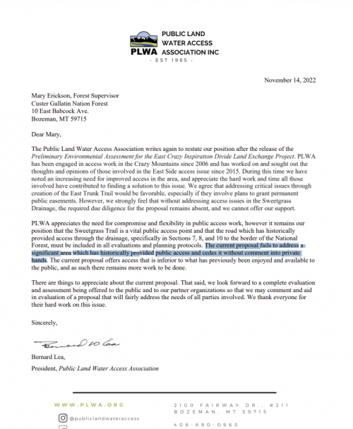
Here is PLWA's letter. I spent some time on the phone with Bernie and I can't quite pin down what they are hung up on.

One key sentence is "The current proposal fails to address a significant area which has historically provided public access and cedes it without comment into private hands." It has also been a concern of mine that we will be giving up public land with a road on it, but nothing being done to address the status of that road/trail after it changes hands. (Sweet Grass trail is actually a road that stops at Eagle Park on public land)

There is an issue at the end of the road, which currently stops on public land at Eagle Park. That stopping point will change to private ownership. If the road is eventually proved public, will we be able to park there? That needs to be addressed.

1668476396998.png
 
Here is PLWA's letter. I spent some time on the phone with Bernie and I can't quite pin down what they want.

One key sentence is "The current proposal fails to address a significant area which has historically provided public access and cedes it without comment into private hands." It has also been a concern of mine that we will be giving up public land with a road on it, but nothing being done to address the status of that road/trail after it changes hands. (Sweet Grass trail is actually a road that stops at Eagle Park on public land)

There is an issue at the end of the road, which currently stops on public land at Eagle Park. That stopping point will change to private ownership. If the road is eventually proved public, will we be able to park there? That needs to be addressed.

View attachment 250124
I agree. As PLWA stated, there remains a lot of work to be done.
 
I spoke with FWP's Region 5 elk biologist about HD580 (that is the HD where the proposed land exchange will occur). He confirmed what already know: The public is losing the best elk habitat in this exchange. He was very careful not to take a position on the exchange. The fact is the exchange asks the public to trade productive low-country public parcels for steeper high-country private parcels. Elk generally prefer the low-country land where there is shelter, food, water and living is easy. This distribution is backed up by FWP's aerial surveys.

HD580's population objective is 975 elk, however 4,215 elk were observed in 2021. Elk wonder and can be found all over the range, however the large majority of the elk population permanently reside on the low-country landscape - the parcels the public will lose in this exchange.

FWP uses Sweet Grass Creek as feature to define zones within the HD. They provide elk counts south of Sweet Grass Creek to Big Timber Creek and north of Sweet Grass Creek to Cottonwood Creek. The zones differ in many ways and should not be used for 'apples to apples' comparisons.

FWP observed 2,403 elk from Sweet Grass Creek to Cottonwood Creek. The elk population is very high in this zone. The YC's proposed swap will result in the loss of reasonable public access into Sweet Grass drainage. We give up our current legal access of less than a mile onto public land for a 22-mile trail. The elk population in this zone is high and the YC's swap will make it way more difficult for the public to access. Watch for the landowners to continue to deny public access during the hunting season and request help from FWP via late season shoulder season hunts. This happened last year and access to cow elk hunts were sold late in the year.

FWP observed 224 elk from Sweet Grass Creek to Big Timber Creek. The elk population is in decline in this zone. It is also where the majority of the proposed swap and public consolidation will occur. The YC's swap will add significantly more pressure and further reduce population by pushing elk lower and deeper onto private.

I figured since this Hunt Talk and ultimately supposed to be about hunting, we should discuss elk. This exchange was not written by or for the elk hunter. It does not benefit the elk hunter. Look at it and ask yourself what the public gives up and what landowners give up and are those things equal?
 
@John B. Sullivan III what exactly is the current status of the swap? If someone wanted to comment against it, when is the correct time? What is or could be done to actually gain public access besides this swap? I hear a lot of complaints but not a lot of other solutions.
 
@John B. Sullivan III what exactly is the current status of the swap? If someone wanted to comment against it, when is the correct time? What is or could be done to actually gain public access besides this swap? I hear a lot of complaints but not a lot of other solutions.
At this time the swap is simply a proposal from the USFS. The public comment period began on Nov 7th and ends on Dec 22nd. You can read the details and comment here: https://www.fs.usda.gov/project/?project=63115

The conservation community presented many solutions to the CGNF and YC in order to gain support. All those solutions were based on equitable trades and dismissed by the landowners. The opportunity to stop or change the action is now and requires a lot of public outcry, just like the opposition to Utah-based POWDR developing Holland Lake Lodge for skiing.
Ok, but without the exchange the public losing even more land as we can't access it, and as the court ruled, you can't force the FS to defend that access. So where does that leave the public?
 
Yeah, it's good habitat on the east side, but you can't get to it, and you have no viable plans to change that, so your point is moot. How many times have we been through this?
 
FWIW, the proposal has a very bad change which has killed support from all public advocacy groups I am aware of. The FS now want to give up any claim to an easement on the Sweet Grass trail (actually a road, which has less restrictive easement requirements). Allowing that issue to be settled after the swap was a promise from the start.

Hold off on any comments.
 
I read through this entire thread and most of the links again. I still don't like it. It's not terrible, but certainly not something I'd call a "win".
I'm from Gallatin Gateway, now the suburb / mancamp / low rent district of Yellowstone Club & Big Sky. The reality is that there is no "win" when dealing with Cross Harbor Capital and the ring of large private land ownership around the Crazies. You're supposed to thank them for the crumbs they toss. (large sarcasm emoji!!!)
 
I'm from Gallatin Gateway, now the suburb / mancamp / low rent district of Yellowstone Club & Big Sky. The reality is that there is no "win" when dealing with Cross Harbor Capital and the ring of large private land ownership around the Crazies. You're supposed to thank them for the crumbs they toss. (large sarcasm emoji!!!)

Well, on the other hand, if you do nothing they will rob you blind. They could put ski areas on every inholding if they wanted to. In this case they are offering far more than crumbs, but people are throwing them around as a boogeyman while failing to identify specifically what is bad for the public. That's a big red flag.

In this recent proposal they threw in Smeller Lake. That's hardly a crumb.
 
The thing that sticks out to me as others have stated is that most all the usable/ prime land is going to private hands. In my opinion the public would be getting borderline useless pieces of ground. With that in mind what is the purpose of this going forward. Its basically a concession to the private land owners. Also what is the point of the trail, its so long only a small small handful of guys on horses would ever even use it every year. Once a person rode into sweet grass you could hardly even hunt it as most the low lying/ elky parts would be private. Seems like a giant L for the public
 

Latest posts

Forum statistics

Threads
114,415
Messages
2,056,624
Members
36,589
Latest member
Finchley3746
Back
Top