Caribou Gear

East Crazy Mountain Land Exchange

Am I wrong in that this would consolidate access down to essentially one point via Half Moon? I'm not intimately familiar with the area, but @RobG you sound like you are- Can someone currently access 12, 24, and 36, as well as 2 (there by making 34 a bit more "direct") ?
You can currently access section 34 using section 2 although it is a steep walk. That access will be replaced by one at Half Moon. I wish we could keep 2 as it is quicker, but that is where the Switchback Ranch's guest cabins are.

The trail (#115) to 12, 24, and 36 is contested (and posted) and the sheriff is enforcing it. Long before I went in there the Forest Service was calling it contested and I'm pretty sure I have a picture of a map Alex drew up if people don't believe me.

John S says the trails are public, but the landowners are equally adamite that it is private. No matter how mad each party gets or how much they don't like the process, a judge has to determine if it is public or private. Unfortunately, when a landowner says a trail is private the burden is on the public to prove it is a public trail.
 
I think there is a reason that BHA is not backing this trade . There is no reason to trade the lower sections for the upper sections . There is no reason to make a trade just to make a trade . Giving away the lower sections will provide land to private landowners to subdivide . Those upper sections are basically useless if there is such a thing with land, the lower sections provide far better habitat for the game animals . I think it would be better to just wait and have someone with the best interest of the people in mind to do something about this than somebody with private land interest being the largest benefit from the trade .
It's a concern that is trying to be addressed. Crazy Peak will have a conservation easement as well as guaranteed access for the Crow Tribe. Conservation easements are in the works for S8 and S10, which are the two sections in the Sweet Grass creek.

I haven't heard anything about CEs for the three sections on the east perimeter but I know people are pushing for them.
 
I've been on Conical and Crazy Peak but still need to bag Iddings. A couple of failed attempts from the West side before I figured a sure two night strategy....from Smelter. :(
Haven't read the specifics to see if I have to go on the sly. ;)
 
I just read the links you provided, some of them for the second time . I can not get past the fact it is a landowner generated proposal . I believe the lower Forest Service sections are worth millions and the upper sections the landowners are offering are worth thousands .

I can look out the window of the house I am staying in on the west side of the Crazies and see sections of land the Yellowstone Club subdivided and put a road to in the last 2 months . They are asking 1.2 million for quarter sections . Going to be houses there in the near future I would guess .

Those upper sections on the east side will not have houses in the near future I'm guessing . If we can hang onto those lower sections as public land they will never be covered in houses . It will not provide access but they will still be ours . I will try to donate to the people working on the trail access .

Best of luck Rob - I understand you are working hard at this and wish you the best .

Proposal
I'm not sure why you think it is a landowner generated proposal. This process started in 2017 with the "working group" which eventually included representation from RMEF, MWF, and various other representatives from the public. They got fairly close and then the Yellowstone Club hired a couple consultants (Tom and Jess) to bring it together (I'll explain YC involvement later).

Once Tom and Jess had something the group would accept they started reaching out to people. Turned out I was the first. I got an email from Erik Nylund (Jon Tester's Natural Resource Liaison) urging me to talk with the Tom and Jess, who he mentioned were straight shooters that he knew for a long time (and not some shady characters).

I gave Tom and Jess my input and they reached out to a wide variety of people including BHA, MWF, etc. Eventually it went entirely public with several open house meetings and calls for public input. I was even on TV about it. Because of that input the conservation easements were added. Some other ideas were put on the table. This level of public outreach is unusual for any trade and we haven't even got to the place where it is historically solicited.

Only after all that public involvement was it sent to the USFS last week. Now it will go through another level of scrutiny.


Regarding development....
It's conceivable that the three sections on the east side of the range could be developed, but those are all multi-generational ranches over there with huge blocks of land. If they wanted to develop they could literally create hundreds of ranchettes even if the swap didn't go through. (And I can assure you their existing private land is very prime elk habitat!) In the bigger picture, these sections don't add to that threat.

Yellowstone Club
Yellowstone Club's involvement in this trade and the Crazy Mountain Ranch purchase adds another layer of conspiracy theory to this whole deal which is really unfortunate. I think the best defense from something like Yellowstone Club is to get rid of the checkerboard or they'll have control of most of the public land in there. Right now we have control of less than two sections...

The Switchback ranch is a big part of this swap, and the owner (David Leuschen) has ties to the Yellowstone Club. He's a mixed bag - he supported wild and scenic designation of the East Rosebud and he is on the board of the Montana Land Reliance, but he also is building a ski hut on one of his inholdings. The important thing is that he is a very positive part of this at this time. However, if the swap doesn't go through he could turn that whole area into a heli-ski operation and leave us with only those two sections of land.

The Yellowstone Club got involved because they needed to contribute more to the public to make a swap adjacent to their ski area more equitable. And if that wasn't bad enough YC bought the CM Ranch in the SW Crazies so people are really trying to get a lot of mileage from it. It is really unfortunate because it makes it easy to generate conspiracies that distract from evaluating this proposal on its merits. Please remember that when you see innuendos involving YC, rather than solid problems.

The truth is we will be way better positioned to deal with YC (and Leuschen) if the swap goes through and the public land is consolidated.


[Edit: note that the law requires the land values to be roughly equal. You can expect so fudging, but not three orders of magnitude, (i.e. millions to thousands).]
 
Last edited:
@Gatekeeper - those aerial photos are great- they certainly display a better "picture" of the habitat and terrain than any map layer I've seen.

Thank you @RobG for your work on this and your explanations, maps, diagrams, articles etc.
Is there any continuing talk about the existing prescriptive easements while the land swap talks have gone on? Or have they been tabled in the meantime.

Anyone with knowledge of the Gallatin Land Swap, I'd be really curious to read more in to how that solution came about, but I don't want to hijack this thread. I probably rushed and missed it in my search on the forum, but is there an existing thread from back in the day regarding that swap? Thanks.
 
New access trail will come out of Big Timber Canyon and you can walk 12 miles for access to Sweet Grass Canyon . That is 24 miles round trip for access .View attachment 190445
The Landowner/Yellowstone Club proposal claims the new trail will be 22 miles one way from the trailhead in Big Timber Canyon to where it meets with Sweet Grass trail. That distance is prohibitive to hunters - it would be near impossible to get an elk out and keep the meat in September temps, even with stock.
 
The Landowner/Yellowstone Club proposal claims the new trail will be 22 miles one way from the trailhead in Big Timber Canyon to where it meets with Sweet Grass trail. That distance is prohibitive to hunters - it would be near impossible to get an elk out and keep the meat in September temps, even with stock.
1) 22 miles is the length of the new trail. You don't have to walk 22 miles to start hunting....
2) You can't hunt any of that stuff now.
 
Sweet Grass Canyon . Dude Ranch bottom right, if this goes through we should be able to walk 10 miles around the ridge to the left and glass 350 bulls on what used to be public land in those green meadows down below .

The difference is that right now you can't even walk to that point to glass those same bulls that are already on private land.

Your pictures of SG canyon are great, but most of that land is already private. Those green meadows are private or have a road going right through them.

The first public section is 1/4 mile from the Sweet Grass ranch that has pay hunting. The creek goes dry in the summer. Do you really think that is going to be great elk hunting and fishing for the public?
 
Last edited:
The difference is that right now you can't even walk to that point to glass those same bulls that are already on private land.

Your pictures of SG canyon are great, but most of that land is already private. Those green meadows are private or have a road going right through them.

The first public section is 1/4 mile from the Sweet Grass ranch that has pay hunting. The creek goes dry in the summer. Do you really think that is going to be great elk hunting and fishing for the public?

This is what really bugs me about the vocal opposition to this exchange. They put up a bunch of stuff that looks damning but the reality is a lot different. The reality is that we have almost nothing now.
As someone who hunted there a few decades ago, I support what Rob is expressing. First it was some limited access with permission, then it was some limited Block Management, then pay-for-access hunting, then mostly outfitting ... and now essentially NO access for DIY hunter or outdoor recreationist to private or to public land.

The reality recognized years ago is that the large landowners hold all the face cards, so the public has been dealt a bad hand. The prescriptive easement bluff has been called time and again, so let's figure out a better game to open access. Simply put, "Something is better than nothing." Certainly not my ideal, but at least something for my grandkids.
 
The reality is that we have almost nothing now.
That's sort of the two sides of the coin right? I mean we have basically nothing but hope right now vs is this deal goes through we get to use lands we currently cannot but no longer have hope anymore that there will be a big win for the public access. I can easily see both sides. Hope is powerful.

Question, how much value is being added to the private ranches through this deal? There is certainly some value in controlling public land via the existing checkerboard, but there is also drawbacks, I mean how much value are they getting out of these steeper, higher elevation sections that are mostly rock (ie 23, 27, 33)? How easy is it for them to run a road or utilities across FS lands to access their landlocked sections? That certainly gets easier with consolidation.
 
The Landowner/Yellowstone Club proposal claims the new trail will be 22 miles one way from the trailhead in Big Timber Canyon to where it meets with Sweet Grass trail. That distance is prohibitive to hunters - it would be near impossible to get an elk out and keep the meat in September temps, even with stock.
Hawks Rest in the Thorofare of Wyoming is 25 miles one-way from the trailhead. A bunch of elk are killed by hunters at the HR and salvaged. A bunch of elk are killed in the country along the way to the HR.

I thought BHA was for having a bunch of country that people had to work hard to get to. Heck you could walk in 22 miles, kill an elk and you would be the winner of the "how far from the road" picture contest BHA puts in every journal.
 
2 square miles in the bottom of Sweet Grass Creek are public land . That is a fact .

" This is what really bugs me about the vocal opposition to this exchange. They put up a bunch of stuff that looks damning but the reality is a lot different . The reality is we have almost nothing now ."

I have simply posted pictures and a map that I found on the internet while researching this subject that you posted about . I have tried to show my view on this subject . You seem to have an issue with somebody speaking up .

I will shut up and walk away from this thread because of Randy's post the other day .
My apologies. I shouldn't have said that and deleted it. My frustration is not with you but others that don't want to see this swap go through for personal reasons. It is very time consuming to set the record straight.

I swore I wouldn't give the appearance of arguing but I messed up. You were providing good information that deserved a better response.

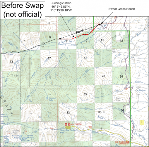
Consider the map below. Section 10 is that nice flat spot. It has a private road going through it and a stream that goes dry or is very dewatered because it goes underground. There are several buildings at the edge of section 9 (Google 46° 6'46.85"N, 110°13'39.18"W and set layer to satellite). One is a cabin or residence if I recall correctly. Also, if I recall correctly, there was logging going on in section 9 when I visited years ago.

The point being that S10 isn't a wild or pristine place, and in my opinion doesn't appear to offer great recreation opportunities.

As soon as they get the fire under control I'm going to visit these areas and I'll announce it here and invite anyone to join me. It's a beautiful canyon, but not pristine.


before (road, building).png.
 
Hawks Rest in the Thorofare of Wyoming is 25 miles one-way from the trailhead. A bunch of elk are killed by hunters at the HR and salvaged. A bunch of elk are killed in the country along the way to the HR.

I thought BHA was for having a bunch of country that people had to work hard to get to. Heck you could walk in 22 miles, kill an elk and you would be the winner of the "how far from the road" picture contest BHA puts in every journal.
Good to know - HR sounds like a great backcountry adventure/opportunity and I like elk hunting success stories like that. I don't think I could get an elk out 22 miles during September heat and save the meat. Maybe others can.

Does anyone know if there are any consistent/reliable water sources between Big Timber Canyon and Sweet Grass Canyon, along the proposed trail?

Of course BHA loves backcountry. The working hard part is kinda relative - some of our best public lands require effort to access and some don't. They also like to preserve historic and legal public access to those lands.

Montana BHA pledged full support for this proposal if it included the restoration of the public's right of unobstructed public access along Sweet Grass trail #122. Unfortunately that was a nonstarter. There would be no land swap proposal from them that included the restoration of the public's rights on that trail.

Why are we considering giving up our legal access and the only low country public land on Sweet Grass creek for a proposal another commenter described as "something is better than nothing"? I fully support searching for an equal solution, but it cannot be done with unreasonable people who refuse to accept the public's rights.
 
Last edited:
No dog in this fight. Never been to this place and probably never will. However, I want to thank the people (RobG especially) for volunteering their time and efforts to do what they think is right. I don't know if this is a good deal or not for the public (despite reading the whole thread). RobG thinks it is and he is putting in the time, so I gotta believe it is at least an okay deal at the minimum. Without people volunteering, where would be be on deals like this? probably way worse off. So from Joe Q. Public, thanks to those that have volunteered, it is appreciated by sportsmen all over the country like myself who will never even go there!

That is all, carry on.
 
I don’t have strong feelings pro or con to the land swap but I am wondering what steps with resolving the disputed trail status BHA and other opponents are taking?

What does the public stand to gain or preserve if the land swap doesn’t go through and we lose a court case to access the trail?
 
I don’t have strong feelings pro or con to the land swap but I am wondering what steps with resolving the disputed trail status BHA and other opponents are taking?

What does the public stand to gain or preserve if the land swap doesn’t go through and we lose a court case to access the trail?
Montana BHA's lawsuit is not directly challenging the status of trails. The lawsuit challenges the USFS for failing to fulfill their duty to keep public trails open and unobstructed for public use under NFMA. The USFS maintained the practice of fighting to keep these trails for open and unobstructed for public use from ~1906 until ~2016. Things only changed after Sen. Daines, Sen. Session, Chief Tidwell and Sonny Purdue got involved in 2016.

The fact is there are mountains of evidence, court cases, statements under oath, USFS official positions, etc affirming the prescriptive easements.

Montana BHA's case is an attempt to compel the USFS to return to their long standing practice of keeping these trails open and unobstructed for public use.

Should this swap go through, the public will lose its only lowland sections on Sweet Grass Creek and, without any guarantees, we should assume the historic Sweet Grass trail #122 will be shut permanently and removed from maps.

What are the landowners giving up to make this swap even with what the public gives up?
 

Forum statistics

Threads
114,417
Messages
2,056,724
Members
36,591
Latest member
SwampWitch
Back
Top