Leupold BX-4 Rangefinding Binoculars

OnX is not always correct

View attachment 208531

... land work in West Virginia, always interesting.


100% agree, although a boundary survey can also led to major title issues so is one reason why it's often not done. I've been a part of a couple transactions where a re-survey would have lead to a title company not insuring title, essentially the resurvey would cloud title.

What's kinda interesting in O/G is you have to pay apportiontly based on acreage in a drilling unit. Meaning exact acreage is important, and often your in communities where farms have been owned by the same families for generations, and those families have 0 intention of ever selling. So it's kinda unlike normal real estate work where a developer is buying a property to subdivide or someone is trying to sell their property and "clean it up"... and it's not one property. You are trying to get 500 hundred small farms to all have perfect boundary lines with no vertices overlap so you can say:

In this 2000 acre unit:

Jim Owens = 22.3 acres
Brad Jones = 25.3 acres
Jill Bradford= 29.0 acres

and the sum of all the acreage needs to add up to exactly 2000 acres.

I think most surveyors do a really good job, but rarely does a surveyor company get tasked with cutting up 30,000 acres of 25 acre-ish tracts in order to pay out 100MM, and you aren't creating a new subdivisions where it starts out perfect, you are reconciling deeds that are all over 100+ years old, so if you make any change someone is getting hosed.

And as you might imagine no one is ever upset that the family "100 acre farm that has been in my family for 5 generations" is now 84.7 acres.
Those changes that are made are not made lightly. The surveyor is on the line as well as his professional career. When those changes are made, likely the surveyor has walked back the entire original description. These old descriptions aren’t as clear cut as more modern ones as it was likely at some point landmarks were used but the intent is what they are wanting. Did the original surveyor intend those corners to be where the retracing surveyor has his corners identified.

As far as comment referring to parcels, it will be real unlikely to get let’s say a section to add up to 640 acres. Yes that’s what they should be but if your bearings are shown in more than degrees and minutes it’s likely you won’t see 640. This yes can be resolved by only showing less detail.
 
100% agree, although a boundary survey can also led to major title issues so is one reason why it's often not done. I've been a part of a couple transactions where a re-survey would have lead to a title company not insuring title, essentially the resurvey would cloud title.
I can't imagine someone going through with a land conveyance after knowing that a survey would cloud title for that particular parcel. That just seems crazy to me. This is the exact reason to have a parcel surveyed as well as having an updated abstract and title report done when purchasing a piece of property.

FWIW a Boundary survey can not tell you who owns the parcel, it can only tell you where the boundary lines are located.
 
FWIW a Boundary survey can not tell you who owns the parcel, it can only tell you where the boundary lines are located.
Exactly! My most recent example was a situation with a piece of shore line. Basically the original deed didn't specifically call out the shore, just lot and block, and a resurvey would have needed to include the shore, and the title company wouldn't insure title because there wasn't a clear chain of conveyance of the shoreline. Path forward was to use the original legal, get insurance for that portion of the property and then file a quite title suit for the shoreline. Once the suit had been completed the title company agreed to insure the whole property. Which I guess at that point could have been re-surveyed. Total cluster of a project.
As far as comment referring to parcels, it will be real unlikely to get let’s say a section to add up to 640 acres. Yes that’s what they should be but if your bearings are shown in more than degrees and minutes it’s likely you won’t see 640. This yes can be resolved by only showing less detail.
Agree, although I was referring to projects in non-Jeffersonian states. So all the "Beginning" points aren't Section or township callouts but to other properties corners, Proceed xxx feet at xxxx bearing from the Northern most corner of Jim's property that being the most west corner of Bob's property to a fences, rivers, trees, rock piles... that point being the Beginning of the xxx tract.

I even had a deed once from Pecos county, TX where the unit of measure was 30 min at a walk (horseback). That was on the first deed out of the original land grant.
 
Last edited by a moderator:
Yes. Do you have any idea why it jumped around like that when I was stationary, but not when I was walking?
Likely multipathing between satellites and gps. This will happen when there is a canopy of tree cover or in tight quarters such as a city block with very high buildings. The bouncing of satellite signal.
 
I was shocked to see it show a bunch of trails across our family’s property. Made it look very inviting. The main trail it showed was a single track path that trespassing mountain bikers have made. We have blocked it off many times but they continue to go through. Somehow in heavy timber OnX shows it as a trail or road. There are also others that show up on there that were logging trails made from skidders when we logged it. I figure it must use something that picks up stuff from aerial imagery.
Not sure on private parcels on onX, but I've found Google maps pulls data from user created databases like mountain bike protect, trail forks, etc that is not validated.
Also old topos with roads will sometimes have that data transferred to pubic land that aren't in existence anymore. I was a federal park ranger that covered 2.5 million acres of dessert and loved comparing the two.
Then a crew on side by sides would just set of across the desert and we would have a new road😂😤🤷
 
Last edited:
I figured out OnX isn't always right right away. First thing I checked was my own house that I’ve owned for over 2 years, and it said (and STILL says) it’s owned by the previous owner.
 
A former coworker was told by OnX that their road layers were obtained from the U.S. Census Bureau.

This, after said coworker was contacted by OnX after she wrote up and posted a news release during hunting season explaining there were several (23 I believe) road segments shown on OnX that did not even exist.

A representative from OnX called said coworker to find out why the news release was issued. Coworker explained landowners were upset because hunters were trying to find the "roads" on their property and hunters were upset because they could not find these "roads" that were shown on their OnX maps.

ClearCreek
 
Heading to Montana for spring bear and wondering if my Huntstand app will cut it? Anyone had any experience with their offline maps?
 
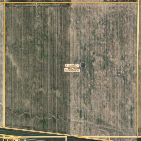
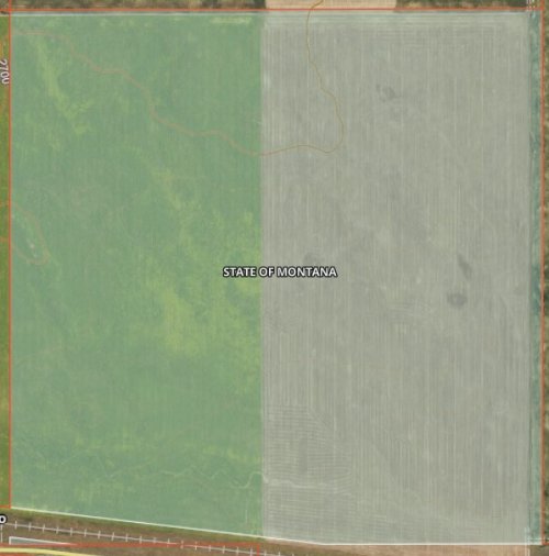
Does anyone know if OnX can portray MT state lands with a perimeter instead of polygon shading.
I find GaiGPS much easier from that perspective
GaiGPS:
gaia_gps.JPG
OnX:
onX.jpg
 
Only other suggestion I had would have been is to use layer transparency of the state, blm and fs show up on the map, but that doesn't seem to be an option.
Or turn land status off/on with property labels, but probably not the convenience you were wanting.
 
Are you asking if the colors can go away? If so, please no, makes it VERY Easy to look at a large map and tell by color what land is what.
 
Use Promo Code Randy for 20% off OutdoorClass

Latest posts

Forum statistics

Threads
114,311
Messages
2,052,338
Members
36,548
Latest member
Prodeoetpatria
Back
Top