Leupold BX-4 Rangefinding Binoculars

Is this hikeable?

JFish

Well-known member
Joined
Mar 10, 2019
Messages
232
Location
Pennsylvania
I’m in the planning phase of picking areas to hunt for an archery elk hunt. Scouring OnX and paper maps I was interested in this slope, but after looking at the elevation gain I realized it’s much steeper then it looks. For those of you with more experience what is the suck level of this slope. Is it doable, or would you consider this standard hiking for western mountains? What elevation gain “per mile” would you consider to be realistic or unrealistic? E4CC2EF4-E5C2-49B1-B606-8E35BA98CC73.jpeg
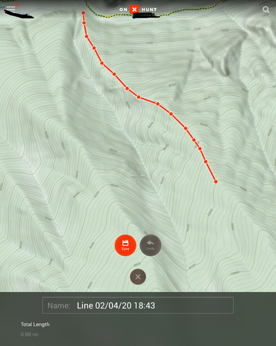
 
I wanted to hike up a slope that that this past year, but when I saw it i knew I was never making it up. Those maps can be tricky to read due to the fact that they show elevation gain in every 200ft increments. This fact is you would be hiking straight up a mountain. 1000ft maybe every mile, but sometimes that is to much too.
 
Yikes. Huge potential for that to be a cliff and or really scary.
 
If you can, I'd pull that up on google earth to get a better 'look' at the terrain. That said, maps and google earth in the comfort of the house don't always translate to the real thing.
 
so reading that, I see 2600 feet of gain in a mile. 2600/5280=49% slope. Pretty steep...26.5 degrees. house stairs are 30-35 degrees

Put another way it’s as steep as a lot of black diamond ski runs. Stairs are a tough comparison because their are steps, so this is steep than house stair but likely with supper shitty footing.
 
The slope would suck, but doable. About a million variables that you can't tell from that screenshot though. Looks like that ridge probably has cliffs, it's a north face so what's the timber/brush situation, etc.

Also just from topo alone it doesn't look your gain much from a hunting perspective from making that climb, unless you know there's some wallows/benches up in that canyon you can't see on the topo.
 
2k+ ft in a mile with no established trail and some trees and brush thrown in sucks a bunch. At 2,600 that is a no go for me in all situations I have been in for elk and deer. The mountains are not that big in the areas I usually hunt, so the distances are not as long. 1k ft gain/loss in a mile is pretty normal and pretty much required to get to any spots that look good, 1,500 ft a mile happens quite a bit too but if it gets beyond that I look at other spots. I frequently end up in spots that are 1k ft in 1/2 mile or so, add in alders and maple brush growing sideways and it is not very fun.
 
It's all perspective I guess.

While the route you picked might not be doable, the hill is definitely huntable. I hunt hillsides for whitetail that steep all the time, buy I don't take routes like that. Poke around a bit and you'll figure out a way up there.

You do have to get over the idea that you might put in five or six miles to get to a spot that where it feels like you can spit on your rig.
 
Thanks for the replies and input all. I think I will cross off that slope from the list. I’ve got plenty of time left to scour some more maps until next fall.
 
With an established trail, switchbacks , etc . That would be very doable. Without, it may be pretty tough.
 
And also think about trying to get up or down in the dark. And one thing I have learned about all the mapping systems... The stuff is a lot thicker than it looks.

Me to my partner last summer. " that ridge looks pretty clean and we can side hill around that rim to get on top"
Me on said side hill after damn near falling for the 28th time and rolling all the way down the slope after catching my pack on one of the 4 millions scrub trees just waiting to poke me in the eyeballs " Why did go this way again?"
 
MTNTOUGH - Use promo code RANDY for 30 days free

Forum statistics

Threads
113,675
Messages
2,029,351
Members
36,279
Latest member
TURKEY NUT
Back
Top