Gastro Gnome - Eat Better Wherever

East Crazy Mountain Land Exchange

RobG

Well-known member
Joined
Dec 10, 2010
Messages
5,738
Location
Bozeman, MT
This is something I've been involved in since I was cited for trespassing while using a Forest Service trail in 2017. The proposal has been submitted to the Forest Service. After they look at it and check the feasibility and modify if necessary then it will go out for public comment.

It's not perfect, but it consolidates a lot of checkerboard. Right now that whole east side is defacto private because of the checkerboard. If we don't do something about it a group, such as the Yellowstone Club, can use the whole area as their own private playground - including exclusive access to Cave Lake where the state record golden trout was caught.


To help cut through the BS some people are spinning, look at the "Land Exchange Proposal" and "FAQ" at the top of the page.

For more info, here is a three part series that was recently published by Montana Free Press.
https://montanafreepress.org/.../checkerboard-chess-in.../
https://montanafreepress.org/.../crazy-mountains-access.../
https://montanafreepress.org/.../what-does-future.../...

Montana Wildlife Federation is supportive although last I heard they wanted some things such as first right of refusal if any of the swapped lands come up for sale. I'll try to get their position. Backcountry Hunters and Anglers has been less supportive unless access to Sweet Grass drainage is restored, but unfortunately that isn't even on the table.


There has been much ado about the two public land section that will (may) be given up in Sweet Grass canyon. I would love to keep them, but the stream actually goes underground in those sections during dry summers and they are in very steep canyons so I'm not sure of the recreation value. Upper Rock Creek in the south Crazies also goes underground and it causes the stream to be barren.

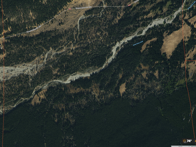
Pictures are from OnX

Section 10, 760 yards from Sweet Grass ranch residence.
1627921466211.png

Section 8, 2.5 mile walk from Sweet Grass trailhead.
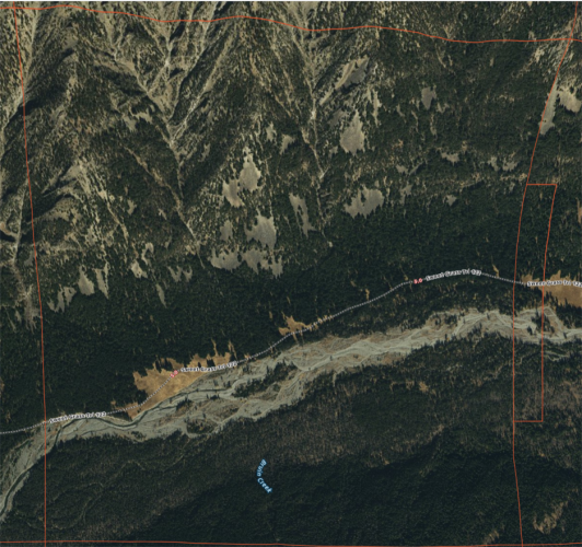
Section 8, Sweet Grass.png

I'm looking forward to seeing how the Forest Service proceeds with this swap.

[Edit, I accidenallty posted 2 screen shots of S10 instead of S8 and S10. I also labeled the sections.]
 
Last edited:
Good on you, @RobG

Curious if RMEF is involved or has weighed in?

I don't know the minutiae of Montana land politics, but I like it when I see coalitions of stakeholders working around the table on something.
You give what have to and keep what you can. There will be those who did not so much as comment who will complain.

Checkerboard is curse. There will always be someone who doesn't like the outcome of swaps, but how else can we fix such a mess?

Raucous threads about corner crossing aren't going to do it. Nor lawsuits really.
 
Thanks for your work on this, Rob. These are very difficult items to sort out, as the public is usually bargaining from a position of weakness, politicians often get involved, and we don't have the funds to compete for market/above market values that can be obtained in private transactions.

Reminds me of how much heat came from doing the Gallatin Exchanges. Fortunately, perfection did not get in the way of remarkable progress.

Hoping good results can come from the work of so many who have been involved in this.
 
I'm not intimately familiar with the area on foot, but have followed this issue for several years. I don't love the proposal. We're definitely giving up more forested terrain than we're getting in return. But it does have it's benefits.
 
Thanks for your work on this, Rob. These are very difficult items to sort out, as the public is usually bargaining from a position of weakness, politicians often get involved, and we don't have the funds to compete for market/above market values that can be obtained in private transactions.

Reminds me of how much heat came from doing the Gallatin Exchanges. Fortunately, perfection did not get in the way of remarkable progress.

Hoping good results can come from the work of so many who have been involved in this.

I've looked through some of the old letters and that swap was quite controversial in the 90s, but now people don't even realize it was at risk in the past.

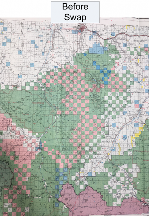
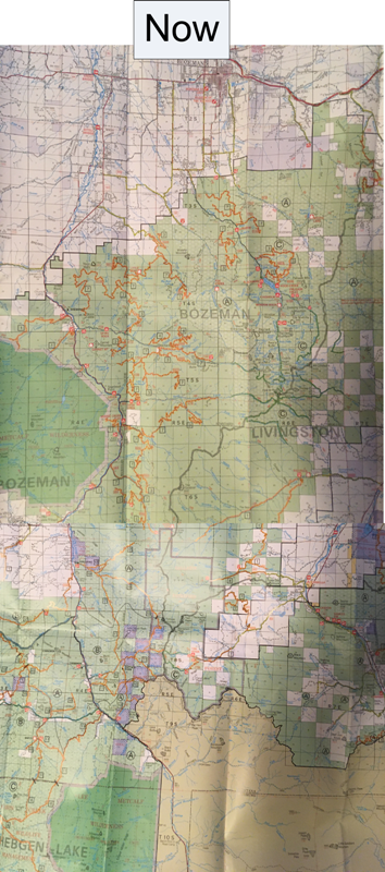
Here are before and after (Gallatin Land Exchange). For reference, Bozeman is at the top of the map, Big Sky is middle left, and Yellowstone Park is at the bottom right.


Before Swap (small).png
After Swap (small).png
 
I've looked through some of the old letters and that swap was quite controversial in the 90s, but now people don't even realize it was at risk in the past.

Here are before and after (Gallatin Land Exchange). For reference, Bozeman is at the top of the map, Big Sky is middle left, and Yellowstone Park is at the bottom right.


View attachment 190254
View attachment 190255
Thanks for illustrating this. The Gallatin Exchanges were huge and resulted in significant improvements for public access, consolidation of public lands, and habitat. Big Fin was a critical voice and influence in bringing this effort to fruition.
I encourage hunters and all public land users in this region to research and learn about this enormous endeavor and the beneficial changes brought about. Also be aware that it could not have happened without RMEF as a driving force and fiscal source.
 
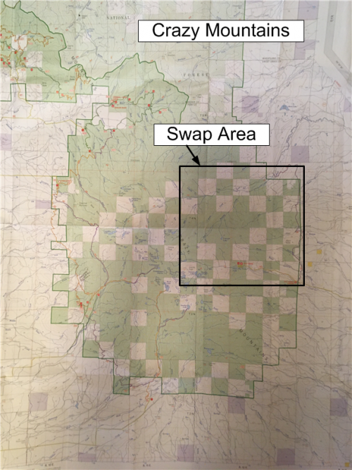
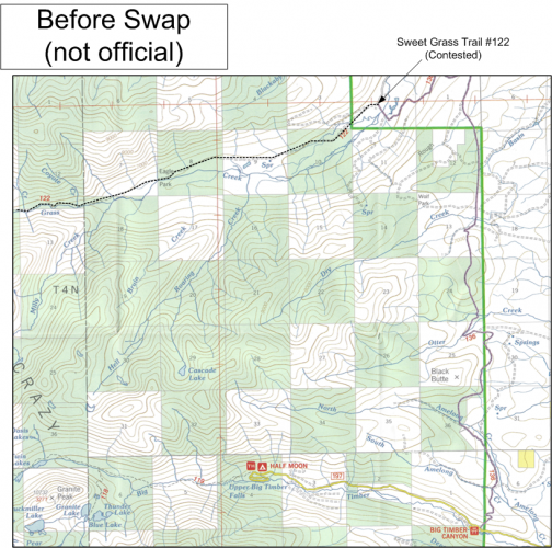
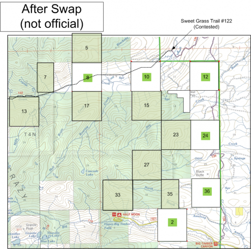
Here is how the East Crazy land exchange would look. As a practical matter, the only land we will give up is section 2 at the bottom. The best land is on the east side: 12, 24, and 36, but they are isolated islands not currently accessible because the landowner has the trail closed. And nobody is interested in taking the landowner on.


Crazy Mountain Overview.png

before (plain).png


after (plain).png
 
I'm not intimately familiar with the area on foot, but have followed this issue for several years. I don't love the proposal. We're definitely giving up more forested terrain than we're getting in return. But it does have it's benefits.
Same. I like the idea of all parties working to compromise more than I like the actual compromise being made in the proposed swap.

I am cognizant hunters are not the only public use group who stands to benefit from the swap and we don’t have much leverage with the landowner, but I’m a bit disappointed by the prime lowland habitat that is being given up. Those lower sections would be the ones I would be most keen to keep.
 
I (and everyone) hear you about the lowland stuff - especially sections 36, 24, and 12, but it's important to remember we don't have access to them now. Even if that trail was opened (and nobody wants to spend the money to do that) they would be isolated islands not large enough to handle much public hunting pressure. MWF would like to see the USFS have first dibs if they ever come up for sale which would be the best case.

Right now the only accessible decent elk hunting land are sections 34 and 2 and the elk move off with any pressure.

I've been on S36. It's ok, but it is comparable to S26 and the west side of S35 which will now be accessible. We'll also gain S23 which is said to be good. S27 looked good when I looked into it. This isn't a rocks/ice for habitat trade by any means.

(caveat - I need to revisit sections 8 and 10 on Sweet Grass Creek - which we would give up. My recollection is that the canyon is too narrow and/or the bottomland is mostly dry cobble streambed so they aren't great hunting or fishing spots. The acquisition of S17 might even be a net gain there.)
 
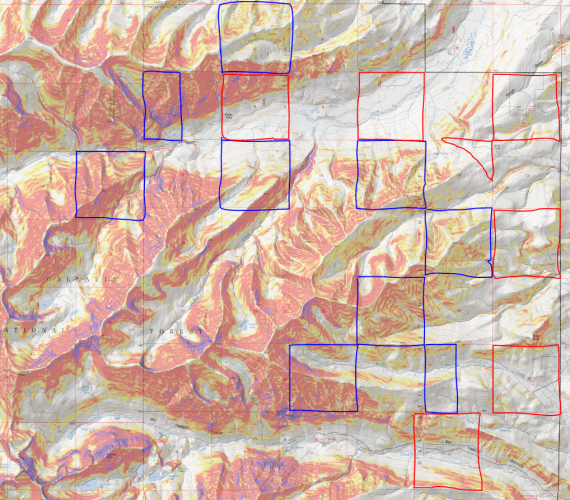
Between the aerial and the slope map, it is hard to see the value in sections 33, 13, and the 1/2 of 7, except of course that they allow access to the adjacent areas.

Note the legend is in degrees and not percent slope.
 
That’s an interesting map. How did you generate it?

Any chance you can outline the existing USFS land that we will gain access to? I think that would show the bigger picture a little more clearly.
 
I think there is a reason that BHA is not backing this trade . There is no reason to trade the lower sections for the upper sections . There is no reason to make a trade just to make a trade . Giving away the lower sections will provide land to private landowners to subdivide . Those upper sections are basically useless if there is such a thing with land, the lower sections provide far better habitat for the game animals . I think it would be better to just wait and have someone with the best interest of the people in mind to do something about this than somebody with private land interest being the largest benefit from the trade .
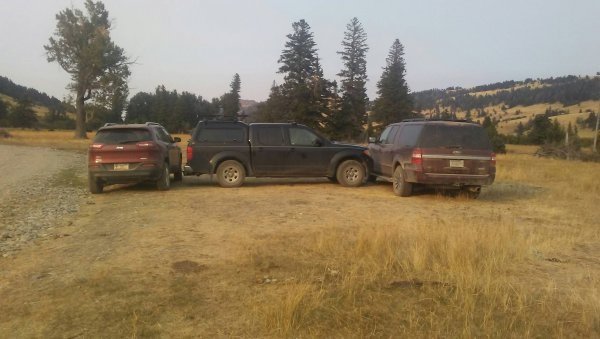
The other reason Montana BHA is not backing this trade is because the trails Rob and the CMAP claim are "contested" are in fact public trails. The whole reason for the proposal falls apart when the public realizes the trails are public and being illegally blocked. In 2007 the USFS defended trail #122 (among a others) as public. A suit was brought by Citizens for Balanced use and a few landowners in opposition to the the 2006 CGNF Travel Management Plan. The USFS kept these trail on the map and listed them as public. The USFS defended their position that the trail should remain public within their travel management plan, and they won in court! Time and again the USFS has declared a public interest in that trail via a prescriptive easement. Most of our access across the west is via prescriptive and that has just as much legal weight and precedent as any other easement. It is only the landowners who are "contesting" trail #122. They are illegally blocking a public trail, they have harassed the public (see pic attached) and they have harassed our public land managers (see removal of Alex S.) in order to get their way. They are betting the public will be unwilling/unable to challenge them to preserve our legal rights, which is becoming a much more common practice. We cannot let that become normal. This proposal was written by those same landowners and the Yellowstone Club, with their intents in mind. The public should demand they remove the illegal obstructions, stop harassing the public, stop harassing our public land managers and then, and only then, should we enter into negotiations about land transfers and/or trail relocations. - John Sullivan.
 

Attachments

  • Sweet Grass Trail Head .jpg
    Sweet Grass Trail Head .jpg
    63.4 KB · Views: 82
Last edited:
Am I wrong in that this would consolidate access down to essentially one point via Half Moon? I'm not intimately familiar with the area, but @RobG you sound like you are- Can someone currently access 12, 24, and 36, as well as 2 (there by making 34 a bit more "direct") ?
 
I believe that there is public access to Cave lake over the top from Big Timber creek. I have been to cave lake and I believe that what exists of a trail crosses section 18. The trail also ends a mile or more from the lake. With the distance involved without an access up Sweetgrass creek, it might still be easier to go over the top.
I don't see any promising route. It looks like you might be able to do it by Conical peak, but that's on private.
 
The other reason Montana BHA is not backing this trade is because the trails Rob and the CMAP claim are "contested" are in fact public trails. The whole reason for the proposal falls apart when the public realizes the trails are public and being illegally blocked. In 2007 the USFS defended trail #122 (among a others) as public. A suit was brought by Citizens for Balanced use and a few landowners in opposition to the the 2006 CGNF Travel Management Plan. The USFS kept these trail on the map and listed them as public. The USFS defended their position that the trail should remain public within their travel management plan, and they won in court! Time and again the USFS has declared a public interest in that trail via a prescriptive easement. Most of our access across the west is via prescriptive and that has just as much legal weight and precedent as any other easement. It is only the landowners who are "contesting" trail #122. They are illegally blocking a public trail, they have harassed the public (see pic attached) and they have harassed our public land managers (see removal of Alex S.) in order to get their way. They are betting the public will be unwilling/unable to challenge them to preserve our legal rights, which is becoming a much more common practice. We cannot let that become normal. This proposal was written by those same landowners and the Yellowstone Club, with their intents in mind. The public should demand they remove the illegal obstructions, stop harassing the public, stop harassing our public land managers and then, and only then, should we enter into negotiations about land transfers and/or trail relocations. - John Sullivan.
I don't disagree, but sometimes concessions to obtain non-contested access is better than no access, which is essentially what the public has now. There is also value in realizing a swap now instead of waiting/hoping/wishing courts will settle the matter and side with the USFS. That will take years, if it ever does happen.

That said, I'm trying to assess the value of access of the new trail and the contiguous access we'd get from the adjacent sections that are marooned now. I haven't hunted all of the areas on the map, but the sections gained are some pretty steep and nasty terrain, as @neffa3 illustrated. Some of the adjacent ones look decent. I wouldn't proclaim to know where all the elk are, but the best habitat is the perimeter and low-lying sections of the range. The biggest bargaining chips we have in the negotiation are those lower, attractive sections that would be now given up.

I think there's a better deal out there for the public. Yet I suspect when it's all said and done, USFS will recommend moving forward with the swap - not least of which because this avoids a protracted and spendy process of litigating.
 
Use Promo Code Randy for 20% off OutdoorClass

Forum statistics

Threads
113,670
Messages
2,029,077
Members
36,277
Latest member
rt3bulldogs
Back
Top