Caribou Gear Tarp

Ask your onX Hunt questions here!

It is available right now to onX Hunt users with the Elite Membership. If you open your basemap selector button in the lower right hand corner of the map, you will see an option for "Recent Imagery." This is satellite imagery that is taken and updated every two weeks. Since it is updated more frequently, the tradeoff is that it is lower resolution than our standard imagery, but it is still useful for tracking snow levels, crop harvest, water levels, etc.

We'll pass along your recommendation about the old fires to our mapping team for them to take under consideration!
Thanks for the reply. For looking at possible water in tanks in NM, the low resolution does not work…..what are the chances of having them make the most recent image hi resolution?
 
Thanks for the reply. For looking at possible water in tanks in NM, the low resolution does not work…..what are the chances of having them make the most recent image hi resolution?
Unfortunately, that is the highest resolution possible for the recent imagery at this time. Imagery taken via satellite, like recent imagery, is lower resolution than our regular basemap imagery, which is taken via flyover.
 
Is it possible to run two accounts on one device? Would be using two separate email accounts
It is certainly possible. You'll just need to log out of the first account and then log into the second with the separate email address. Make sure you do this when you have good service, though. We have heard of some folks logging out when they don't have cell service or wifi and then they've been unable to log back in until they reach an area with good service.
 
It is certainly possible. You'll just need to log out of the first account and then log into the second with the separate email address. Make sure you do this when you have good service, though. We have heard of some folks logging out when they don't have cell service or wifi and then they've been unable to log back in until they reach an area with good service.
All true. I have a work and personal account and have screwed myself several times by logging out of one account and attempting another. 🤬🤷‍♂️😁
 
@onX Hunt

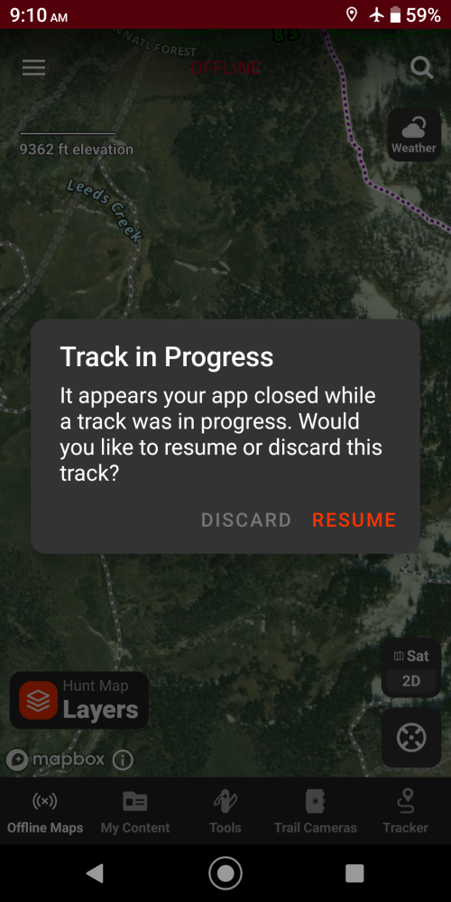
Recent update causes constant app shutdowns and freezes. Sometimes when turn screen on will ask if i want to resume track and then shutdown app after couple mins of locked screen. Real pain when everytime you use app takes multiple trys to save tracks or add waypoint, fix coming? Any update on ability to change default color for tracks/waypoints as previously requested by couple of use?Screenshot_20240622-091027.png
 
@onX Hunt

Recent update causes constant app shutdowns and freezes. Sometimes when turn screen on will ask if i want to resume track and then shutdown app after couple mins of locked screen. Real pain when everytime you use app takes multiple trys to save tracks or add waypoint, fix coming? Any update on ability to change default color for tracks/waypoints as previously requested by couple of use?View attachment 330586
I'm sorry that you're having that crashing issue on your phone! It's probably best to send us an email at [email protected] so that we can take a look at your account and see what the potential culprit is for that issue.

At this time, there are no plans to change the default color of tracks and waypoints, but we will pass your request along to the developers.
 
The majority of western WY high country, has been covered in snow in your images for years now. I have submitted numerous inquiries through the app and so forth over and over, and still, the high country is covered in snow and basically useless. Gros ventre, teton wilderness, wind rivers, washakie etc....Why cant you upgrade your images? This has been years now, to the point i switched to a different app so i could actually have useful images in remote country. Would sure like to know why this cant be addressed easily and update imagery to anything from the summer months. Cause pure white images sure dont do anyone any bit of good.
 
We hear you. The snow covered imagery in western Wyoming is less than ideal. The difficulty in sourcing imagery is multi-faceted: Aerial flights are expensive, so flights are typically flown over areas that are more populated, as there is more demand for imagery in those areas. There is less demand from the general public for imagery in wilderness areas. As result, imagery options for those areas is limited. We also try to balance image recency with image content. Meaning, in some cases, we can get imagery with less snow, but it will be much, much older. Most of the feedback we receive from customers regarding imagery is that they want imagery that is newer, so that is the imagery that we typically prioritize. The good news is that Wyoming is slated for an imagery update this year! We don't have an estimated release date for that new imagery, but we'll reach out to the mapping folks to see if maybe we can bump Wyoming up in the schedule to see if we can get it out a littler sooner.
 
We hear you. The snow covered imagery in western Wyoming is less than ideal. The difficulty in sourcing imagery is multi-faceted: Aerial flights are expensive, so flights are typically flown over areas that are more populated, as there is more demand for imagery in those areas. There is less demand from the general public for imagery in wilderness areas. As result, imagery options for those areas is limited. We also try to balance image recency with image content. Meaning, in some cases, we can get imagery with less snow, but it will be much, much older. Most of the feedback we receive from customers regarding imagery is that they want imagery that is newer, so that is the imagery that we typically prioritize. The good news is that Wyoming is slated for an imagery update this year! We don't have an estimated release date for that new imagery, but we'll reach out to the mapping folks to see if maybe we can bump Wyoming up in the schedule to see if we can get it out a littler sooner.
appreciate the response. I know its not an easy "click a button" type answer for those things, but i appreciate your thoughts and concern on it.
 
Do I get the same layers with my OnX elite membership, that my buddy has using OnX off road? Or does that require another subscription?
 
Got the update on my Android to be able to use the app in my truck's in car screen. But the arrow indicating direction is jumping all over the place constantly. Was in my friend's truck and no such thing takes place on his truck's screen. He has an I phone

Any suggestions?
FYI - When I use just the bluetooth function on my phone (as opposed to plugging it into dash and the GM Android Auto system) it is operating correctly.
 
Do I get the same layers with my OnX elite membership, that my buddy has using OnX off road? Or does that require another subscription?
Much of the information in the Offroad App is also available in the Hunt App. (Such as public/private lands, recreation sites, roads, trails, etc.) The main things you gain with Offroad, which does require a separate subscription, are the color coded roads so you can easily see open/closed dates and the trail reports and current condition reports.
 
Advertisement

Forum statistics

Threads
111,947
Messages
1,975,524
Members
35,388
Latest member
livingt_o_hunt
Back
Top