Navigation
Install the app
How to install the app on iOS
Follow along with the video below to see how to install our site as a web app on your home screen.
Note: This feature may not be available in some browsers.
More options
You are using an out of date browser. It may not display this or other websites correctly.
You should upgrade or use an alternative browser.
You should upgrade or use an alternative browser.
Ask your onX Hunt questions here!
- Thread starter Big Fin
- Start date
rtraverdavis
Well-known member
- Joined
- Oct 20, 2016
- Messages
- 4,083
I used to convert and import the geopdf into my Garmin but for the phone app I have to create tracks for the open roads; same for Wyoming county roads.
Gotcha. I was thinking of doing that, but wasn’t sure if there was a better option. Thanks.
TheNorthStar
Well-known member
Hi, thanks for taking questions.
Mine pertains to the game distribution layers. When I turn on the Elk layer, I get a couple of colors showing; lighter green and a blue.
Is it correct to assume that the blue represents wintering ground and the green is core areas in milder weather months?
Mine pertains to the game distribution layers. When I turn on the Elk layer, I get a couple of colors showing; lighter green and a blue.
Is it correct to assume that the blue represents wintering ground and the green is core areas in milder weather months?
onX Hunt
Active member
- Joined
- Jul 22, 2013
- Messages
- 436
Hi, thanks for taking questions.
Mine pertains to the game distribution layers. When I turn on the Elk layer, I get a couple of colors showing; lighter green and a blue.
Is it correct to assume that the blue represents wintering ground and the green is core areas in milder weather months?
The blue area does pertain to winter ranges and the green area indicate general ranges.
The information comes from the Montana Fish, Wildlife, & Parks.
406LIFE
Well-known member
- Joined
- Aug 18, 2016
- Messages
- 3,127
Ould you add a landscape option as well as option to enlarge the lat long?
HighDesertSage
Well-known member
Sorry, if this has been covered already, but how come the FS MVUM layer seems to disappear at random intervals?
onX Hunt
Active member
- Joined
- Jul 22, 2013
- Messages
- 436
Sorry, if this has been covered already, but how come the FS MVUM layer seems to disappear at random intervals?
If you are zoomed out too far the layer is not designed to load or it would be indistinguishable between various roads but once you zoom in and the highlighted roads appear, they will be available at each subsequent zoom level.
If it is disappearing as you zoom in closer, please reach out to our customer support team at 406-540-1600 or email [email protected] so we can look into this further.
onX Hunt
Active member
- Joined
- Jul 22, 2013
- Messages
- 436
Ould you add a landscape option as well as option to enlarge the lat long?
That is a feature we are looking into. I'll pass along that another person is requesting it. Thank you!
Is there a way to thicken or widen the road layer to help narrow down roadless areas?
crickets...
HighDesertSage
Well-known member
If you are zoomed out too far the layer is not designed to load or it would be indistinguishable between various roads but once you zoom in and the highlighted roads appear, they will be available at each subsequent zoom level.
If it is disappearing as you zoom in closer, please reach out to our customer support team at 406-540-1600 or email [email protected] so we can look into this further.
Sorry I guess I should have been more clear. It doesn't disappear on the map, the ability to use it just goes away.
New issue here I think. I've recently run into the roadblock of 1500 markups. This is a big headache as I'm not surprised I've accumulated this many markups over the past few years with multiple hunts in multiple states. Basically I can't create any new waypoints or routes without selecting some old markups to hide/turn off. The only way to "turn off" markups is by date (location is not that useful currently). I think it would be a huge help to increase this limit or maybe just limit to 1500 markups on the current map area. One of your big competitors looks to address this issue by grouping waypoints when you're very zoomed out into a single waypoint with the tally count of waypoints represented in the icon. I love your guys' app but this markup limit is KILLING me right now.
I have a couple questions about the onX map app. I have a Samsung Galaxy J7 V, it comes with 16GB of internal memory and I have put a micro sd card into it so I could use it for storing maps. The app doesn't seem to have the capability for me to change the downloaded files to the micro sd card instead of the internal memory, therefore I am only able to download 1 map, possibly 2 at a time for offline use. Is there some way to change the app so I can save to the micro sd card? My other issue it seems is that when I am doing a track it seems to lock up once in awhile and I close out the program and start it again and hit resume, but it never resumes. The only way I can get the tracks to start again is to delete the current track and start all over. I have had this happen the last 2 times I have tried to use the tracking feature and therefore lost all my track details. I also saved 3 waypoints yesterday and only the first one showed up on my pc when I got home. Any information about these issues would be greatly appreciated.
WapitiBob
Well-known member
crickets...
the answer is no
onX Hunt
Active member
- Joined
- Jul 22, 2013
- Messages
- 436
I have a couple questions about the onX map app. I have a Samsung Galaxy J7 V, it comes with 16GB of internal memory and I have put a micro sd card into it so I could use it for storing maps. The app doesn't seem to have the capability for me to change the downloaded files to the micro sd card instead of the internal memory, therefore I am only able to download 1 map, possibly 2 at a time for offline use. Is there some way to change the app so I can save to the micro sd card? My other issue it seems is that when I am doing a track it seems to lock up once in awhile and I close out the program and start it again and hit resume, but it never resumes. The only way I can get the tracks to start again is to delete the current track and start all over. I have had this happen the last 2 times I have tried to use the tracking feature and therefore lost all my track details. I also saved 3 waypoints yesterday and only the first one showed up on my pc when I got home. Any information about these issues would be greatly appreciated.
At this time there is not an option to save maps to an external SD card on android devices. We are looking into this option but do not have a timetable as to when it could be available.
If you could provide more information on the second issue in an email to [email protected] that would be appreciated so we can properly assess what the issue is and we have not heard of an issue with tracks occurring with other users.
For the 3rd question, when you mark waypoints out of service, you will want to open the app again once you return to service so that the waypoints can sync up with the servers then they will show up on your account when you log into the Web Map. You can also manually sync up the content by swiping down in the My Content menu until you see the refresh wheel load for a few seconds. Then refresh you Web Map and your content will populate.
onX Hunt
Active member
- Joined
- Jul 22, 2013
- Messages
- 436
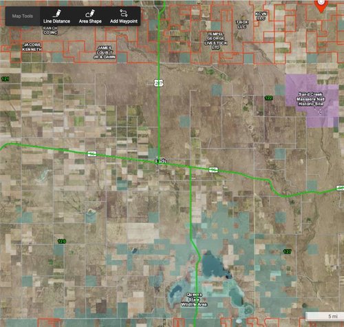
This may have been already covered, but is it common to have gaps in coverage?
View attachment 85512
Some counties don't have the information in a digitized format for us to work with, for those areas, you will get public lands but it will not have the private land boundaries and names.
You can see a full breakdown of what counties are covered and which are not at the link below.
https://www.onxmaps.com/parcel-coverage
WapitiBob
Well-known member
BrentD
Well-known member
I am working with OnX for the first time in preparation to hunt mule deer in Wyoming (Area 36). I have been marking up the maps and noting some big differences between roads on the topo map vs visible from satellite. I also find some a couple big farmsteads/ranches that are not listed as private property but instead as state land. Not sure what's up with them, but they look occupied and well used on the satellite photos, but I'll just avoid them. Lots of other places to go.
Anyway, what I am really looking for is some idea as to how I should download these maps for my cell phone (a Samsung Galaxy 8 if it matters). There are a half dozen subunits in Area 36 that I have identified as places that I want to focus on. They are on the order of 100 sq kilometers in size. Should I plan downloading each subunit separately or one download for the entire Area 36? What makes pragmatic sense when I want to use this in the field?
Anyway, what I am really looking for is some idea as to how I should download these maps for my cell phone (a Samsung Galaxy 8 if it matters). There are a half dozen subunits in Area 36 that I have identified as places that I want to focus on. They are on the order of 100 sq kilometers in size. Should I plan downloading each subunit separately or one download for the entire Area 36? What makes pragmatic sense when I want to use this in the field?
BrentD
Well-known member
I see. It doesnt appear to show any private lands outside of that rectangle.
Now I'm trying to figure out where the maps are stored so I can delete the first ones I made. I didn't center them properly and I'll want to manage them better.
Somewhat frustrating trying to figure some of this out, but I am getting there. I think.
Now I'm trying to figure out where the maps are stored so I can delete the first ones I made. I didn't center them properly and I'll want to manage them better.
Somewhat frustrating trying to figure some of this out, but I am getting there. I think.


