Ollin Magnetic Digiscoping System

Ask your onX Hunt questions here!

My apologies, I thought I would be charged the same as I did when I purchased the chip, I will join the premium membership in the very near future, many thanks for your reply.
Cheers
Richard
Hello Richard, the first year of updates were included with the chip but after that first year you purchased individual updates at $29.99 a piece. Since last year, with an active membership you have access to as many updates as we release for your state. The single state Premium is $29.99/year so you are getting updates to your chip and access on the phone, tablet, and computer at that price now. If you have not had the Premium membership in the past, your account likely did not transfer from the old system to the new system so you would need to create a new account and purchase a membership. You can get 20% off your membership as well using code randy on our website www.onxmaps.com/hunt-app
 
I have a KMZ of a couple hundred points, but I am getting an error message when attempting to import. Works in GE, but not OnX. I can manually put in the points that are most important to me, but if there is an easy fix for the import, that would be awesome. Also, if I have to manually place a few dozen points, can they be packaged to a folder so I can turn them all "off" or all "on" with a single <click>?
 

Attachments

  • Capture.jpg
    Capture.jpg
    37.2 KB · Views: 233
I have a KMZ of a couple hundred points, but I am getting an error message when attempting to import. Works in GE, but not OnX. I can manually put in the points that are most important to me, but if there is an easy fix for the import, that would be awesome. Also, if I have to manually place a few dozen points, can they be packaged to a folder so I can turn them all "off" or all "on" with a single <click>?

There could be some extra parameters on the points that our system is not recognizing. This could be the issue or if the file is too large (the max import is 5MB) that may be the reason as well. Feel free to contact our customer support team and we can try and troubleshoot some things.
As for putting waypoints in folders, that is something we are currently working on. At this time, you can turn ALL your waypoints on/off with one click but not a subset of those. But again, that is coming!

Thanks much. I know it is not a size issue, so must be something else (extra parameters). Thanks for the info on the subset question as well. So far, very happy with the product.
 
Just got back from Black Kettle Wma in Oklahoma. The app worked awesome! My saved maps worked as they should. Just had a few suggestions I felt I wanted while I was there. I wanted a Roost tree icon in the way point selection and really wished there was a way to link this with a Google maps direction app type system to allow me to utilize just this app instead of cross referencing to get to each section of land. This wma is broken into small pieces scattered all over as east Wyoming is. Would be nice to be able to stay in app to get there. I know this is easier said than done. Just wanted to give feedback after my 7 day trip and using this app every day from sun up to sun down.
 
Just got back from Black Kettle Wma in Oklahoma. The app worked awesome! My saved maps worked as they should. Just had a few suggestions I felt I wanted while I was there. I wanted a Roost tree icon in the way point selection and really wished there was a way to link this with a Google maps direction app type system to allow me to utilize just this app instead of cross referencing to get to each section of land. This wma is broken into small pieces scattered all over as east Wyoming is. Would be nice to be able to stay in app to get there. I know this is easier said than done. Just wanted to give feedback after my 7 day trip and using this app every day from sun up to sun down.

You can enable compass mode within the app which will orient the map in the direction you are facing. Tap on the crosshair icon in the bottom right hand corner until it turns into an arrow and that will enable compass mode.
It does not offer turn by turn directions but if you are walking around then you would not need that option. Additionally, you can select a waypoint and select Go-To and it will draw a line from your location to the waypoint, give you the distance to that waypoint, and what direction you need to go
 
on the map, how do I know if a piece of state land is huntable? There is a large section of "state land" where we hunt but how am I sure it is huntable or not? There is also a large chunk of BLM land up the road that I have the same questions about.

Thanks!!
 
minimum size SD card for one state ?

If always connected to cellular, my guess is very little is needed, but for offline, it varies by your resolution option. It allows you to download map portions at hi, med and low res, each taking between 100-300MB. The hi gives you a 5mix5mi square, med 10x10 and lo 150x150. How much storage you need will vary greatly on how much coverage and at what resultion you require.
 
Last edited:
I think I'm going to do this, but how is OnX sold? Is it an annual subscription for the same price every year? Are the same coverages available for each state (e.g. Iowa vs Wyoming)?

There is very little information on what I think is their main website. I sighed up for the trial offer, but seems that it is a somewhat crippled version of the real thing perhaps.

Annual. Not sure year to year. Features vary by state. I think RANDY saves you $50 first year.
 
on the map, how do I know if a piece of state land is huntable? There is a large section of "state land" where we hunt but how am I sure it is huntable or not? There is also a large chunk of BLM land up the road that I have the same questions about.

Thanks!!

You will need to check with your State's wildlife management agency regarding which lands are open to hunting and which are not. This can vary greatly depending on which state you are in and due to this variance, the app will tell you the land ownership but not directly what lands you can hunt
 
I think I'm going to do this, but how is OnX sold? Is it an annual subscription for the same price every year? Are the same coverages available for each state (e.g. Iowa vs Wyoming)?

There is very little information on what I think is their main website. I sighed up for the trial offer, but seems that it is a somewhat crippled version of the real thing perhaps.

It is a yearly renewal fee so that we can update each state's information every year. This map will show you the coverage for private land but every state will show all of the public lands and depending on the state, there may be a private access land program as well (Walk-ins, block management, access yes, etc). You can download the app and start a 7 day risk free trial to see what all information is available in the app
 
As a new subscriber, I find that the software says I can select up to 5 states. I've tried to select 2, WY and IA. The first gives me pretty reasonable detail, the second gives me almost nothing, less that I get from Google Earth.
 
First, I want to say thanks for adjusting the symbology for Sections, and for denoting that State Wildlife Areas in CO versus State lands restricted to hunting!

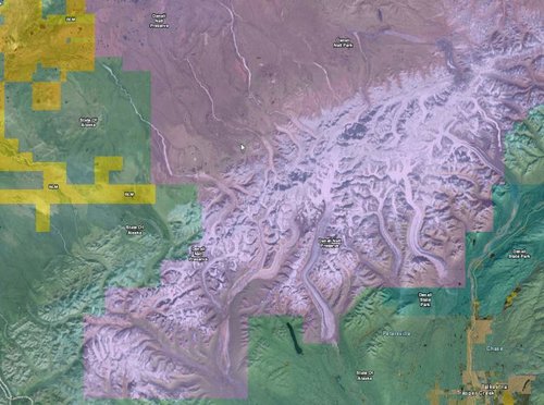
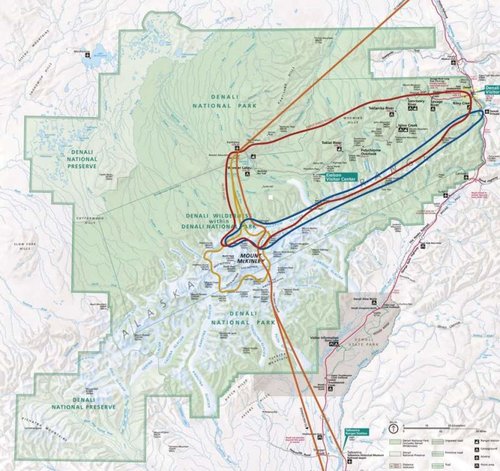
Additional asks, for Alaska can you break out the National Preserve lands from the National Park currently they are both the same color which is problematic as you can hunt in one and not the other.
Also any chance you might add in the subunits in Alaska, it's currently a huge pain to deal with these...
Example: https://www.adfg.alaska.gov/static/hunting/maps/huntmaps/pdf/dl027.pdf

Denali Example:

OnX
D1.jpg

Preserve/Park
D2.jpg
 

Latest posts

Forum statistics

Threads
113,668
Messages
2,029,014
Members
36,276
Latest member
Eller fam
Back
Top