MTNTOUGH - Use promo code RANDY for 30 days free

Wyoming Corner Crossing Defense Fund

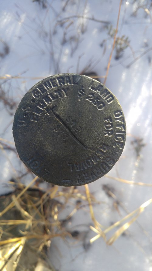
Yep, all the ones I've seen are stamped on the marker too. That doesn't stop people from taking them though.

The fine for taking them ought to be a hefty one though.
reminds me of this case... Someone has to prove the landowner pulled the surveyors pin. Not going to happen.

 
About $7000 in today’s dollars. I wonder what the actual fine is.


View attachment 205360
Ah, the infamous inflation calculator. Now, instead of thinking about corner crossing, I am fretting about the imminent death of fiat currency, the future of America's economy, and the long-term effects our economic struggles will have on the World. Thanks a lot, RobG.
 
I think there is a 50 50 shot on if they are successful. Checkerboard public land sucks. Basically doubles the amount of land the private holder control. Makes me wonder why BLM etc is not working to consolidate our land. I am aware of such land swaps it is just not very frequent. Probably wouldn't be likely though if it reduces the amount of public the private can control and use. Putting a chain and sign at intersecting corners only solidifies to me the internet of the landowner is to control our public ground.
 
What are the chances that the landowners fences are not "exactly" on the property boundaries between these pins? I would imagine that there is a high probability that some of these fences are actually on public property. Is there any way to make sure these fences are not encroaching on public land?.....just spitballing but if a state tries to pass a law making corner crossing illegal then could something be written to make sure "all" boundaries are correctly marked? The time and cost for a landowner to move an incorrect fence might make some kind of compromise feasible.
Most of the survey markers don’t have fences in Carbon County as the rangeland is so vast. The actual corner in question on Elk Mountain is posted earlier in this thread and as you can see no fence just a few metal posts to make it difficult to cross there. Fences are not legal property boundaries in most jurisdictions as they are ruled fence lines of convenience.
 
I believe so. A whopping $250 fine (1953)... if caught. I'm sure a HT surveyor or other guru here would definitely know.
 
Few things of knowledge I'd like to chime in with because I think a few things have been brought up without really knowing much about them.

First off, survey markers are not placed or verified using GPS as stated here:
In Carbon County more than 90% of the corner pins are in place, I personally almost always can find them when out Rock hounding and they were surveyed in the 1960s. They are large brass corner pins which stick up about 14-18 inches above ground. They were all surveyed long prior to GPS days so that begs the question of how accurate they are but my argument would be they met the criteria for an established survey at that time, though many are off by as much as a couple hundred feet according to multiple GPS units I carry to corroborate and triangulate them. If there is no surveyed post you have zero chance for finding that corner without very sophisticated and expensive professional surveyor GPS units.

I work for an engineering firm that does a lot of land surveying. They locate and place new property markers using old and new school technology that involve lasers, rulers, transits, etc. NOT GPS. In the surveying world, its critical that the placement of a marker be extremely previse and that level of precision does not exist with GPS.

Secondly, neffa3 is correct here at least for sure in the State of Wisconsin. I'm not sure if that is correct elsewhere.
sometimes, if two land owners agree that the fence is the property line, over time, mutual acquiescence factors in, but specifically doesn't apply when one party is a public entity.
There are numerous cases where properties in this state had fence lines or roads established that didn't occur exactly on a property boundary and there is such a thing as land abandonment and reclamation by the adjoining land owner. I'm sure someone else here more knowledgably on the legal background of this could chime in. Point just being that if a landowner establishes a fence line as a "property boundary", the location of it is close enough to be assumed as the "property boundary".
 
I'm not a licensed surveyor, but I've absolutely placed corner pins in rural Montana using GPS.

I don't think it's that rare out here.
That's because there are different ways for a property survey to be completed (4 in fact). Of those, there are two that are basically the same thing with one difference and they are called "boundary surveys". These are completed using research of public records, research in the field, and measurements and calculations from the field. A boundary survey will produce a very detailed property plat and will be submitted to the county for certification and record. If a boundary survey results in the surveyor discovering that a section corner marker is off (these markers are buried by the way to ensure they aren't tampered with and there is a device surveyors use to scan the earth and easily locate them), they have the right and authority to correct it and file the correction with the county.
 
So you're saying corner pins can be placed by GPS, as long as they're not part of the boundary?

We had a device to look for the original marker as well, called a shovel.
No, I'm just pointing out that the only thing official and in record is the actual plat map and certified stamped and recorded record of it with the county office. The establishment of these records does not involve GPS nor does the official placement of a marker by a certified surveyor.
 
That just has not been my experience at all. Or my memory is completely botched at this point.

The property I was working on had not had a survey done since the original stones were placed in the early 1900s. When those stones were missing, I could have sworn we used R8s to place new aluminum markers.
Assuming that corner crossing is something you legally and ethically want to do:

Go purchase and print out the plat map for one of the four properties. Go out to that property with a transit and measuring device of your choice and follow the information on the plat map to locate the previse exact corner (dimensions typically are given on the map to the nearest 1/100 of a foot). Cross at that exact point even though the fence line might be 100 feet away or some visual property land survey post marker might be 10 feet away. You will be legal and found not guilty of any trespassing as you are following the legal definition of the property boundaries.

And again...these legal definitions are made without any sort of fancy GPS....
 
reminds me of this case... Someone has to prove the landowner pulled the surveyors pin. Not going to happen.
Easy legislative solution. For purposes of non-destructive corner-crossing, evidence of the use of an up-to-date commercially available GPS to determine corner location creates a rebuttable presumption of the proper corner location. It would then be in the land owner's interest to have evidence of real corners.
 
I dropped my $100 into the fund. Lot less than paying the fines of the first person charged last year, which I also said I would do. Surprised they charged this and wouldn’t be shocked if they dropped it to avoid a legal outcome.
 
In case anyone is bored and/or interested, here is a link to the US Supreme Court Case Leo Sheep Co. v. United States referenced supra. 440 U.S. 668 (1979). If nothing else, it provides an interesting history of how we got to the current "western checkerboard problem."


Below are links to some older US Supreme Court Cases cited to in Leo Sheep Co. or in the cases cited therein.

Camfield v. United States, 167 U.S. 518 (1897)

Buford v. Houtz, 133 U.S. 320 (1890)

This 2019 UCLA Law Review Comment by John W. Sheridan does a pretty good job summarizing the current issues regarding the "western checkerboard problem," how it developed and possible solutions, all while using modern language, unlike Camfield and Buford.

The Legal Landscape of America's Landlocked Property, 37 UCLA J. Envtl. L. & Pol'y 229
 
Last edited:
Advertisement

Latest posts

Forum statistics

Threads
114,031
Messages
2,041,905
Members
36,438
Latest member
SGP
Back
Top