Idaho panhandle elk

E-Rock

Member
Joined
Oct 10, 2017
Messages
57
Location
CDA, ID
Hey y'all, first time elk hunting this fall. Currently live in Minnesota (but might be getting a job in Spokane) and picked up a northern idaho/panhandle region tag season B and will be using rifle. I am leaving for unit 9 and the snow peak wilderness. Hunter Numbers seem low in this unit, so we won't be bumping others, hopefully. But just wondering if any local people can confirm the hunter numbers. Also we I am thinking of camping off a forest service road so we can drive for different trail heads each day and have the ability to be mobile (looking to hike 2-4 miles in each day). Just wondering if that is the best way to hunt this area, or if a camp a few miles in is better. I do have a couple buddies joining me, one had never hunted, and one just started hunting whitetail this past year, but they say they are good hikers, so I will have help carrying anything out.

Also would it seems like this area is good for whitetail, should I pick up a deer tag also??

Thanks for any help! Honestly, I'm going into this as a learning experience, hoping to see elk, but knowing it may not happen. But we shall see come October!
 
I used to live in Liberty Lake and Worked in Spokane for a few year. I spent alot of time up in the country between priest lake and Bonner's Ferry. I never did see an elk when I was up there. Not saying they're not in there, I just never came across any. I think densities are low. Maybe 9, which is further south I believe might be better. I would definitely get a whitetail tag. I'd think you'd have a pretty good shot at filling that. The country is thick. Find gated logging roads.
 
From my reading and listening to podcast, that seemed like the case of possibly lower elk density of they may be better at hiding �� but still trying! And will do! Thanks for your input, whitetail tag will probably be added soon.
 
I used to hunt that area back in the 90's when I lived in Idaho. Haven't been back since. It was a popular area back then. Had some nice whitetails. It's thick country and my longest shot was 40 yards. Would be a better place to bow hunt IMO.
 
I live in Coeur d'Alene and moved here from MN last July so still a newbie to the area. I managed to hunt a couple days on Panhandle A tag last year and found good elk sign but was mainly exploring/scouting and did not have much time to hunt due to my new job. I have done some hiking or driving thru on forest roads of multiple units in the Panhandle and saw good numbers of elk this spring and narrowed down some areas quite a bit. Being new to the area, I am leaning more towards being mobile vs. hiking in and setting up camp. I have found some decent sign just parking where the road has a wide spot and getting off the road 1/2 mile to spots that looked good on maps. So don't rely too much on trail head locations. Find a spot that looks promising on a topo map and find a place to park nearby and hike in.

My understanding is that there are lower hunter numbers in that area, but also lower elk numbers. I do want to hunt that area myself when I have a few more days available than I do for this year. With less access points I assume the lower hunter numbers are concentrated near access points so it would still be tough to get away from them. Also, B season could be rough weather. Last year there was a big dump of snow in early October. Some of the higher areas down there had 12+ inches, but most of it melted in a few days. You will want chains with and be prepared to move if a storm is coming in.

I have been in a couple spots that it is possible to glass, but it won't be like pictures or videos you see of other western states. Trees and brush are thick everywhere in the northern areas.

You won't have to worry about altitude when hunting here, but be ready for the steepness. All of the creek bottoms and ridge tops are very narrow and there can be 2k+ ft of elevation change over a short distance. Takes a lot of work to get your legs in shape for the climbing up and down. Don't take your buddies word for it that they are good hikers, find out what their actual training is.

I have seen some good deer, and even caught a glimpse of an elusive panhandle mule deer buck last August. So it would be good to have that tag in your pocket.

Hey, thanks for the input! Hope the move out there has been good. It seems like a beautiful area, and am leaning on living in Post falls area if the Job in spokane works out.

But definitely will talk with them about working out. Ive been hitting the gym and some of the hills around Duluth, but I know that I will probably still get beat up there for the first time. But always taking a learning experience.
 
Hey y'all, first time elk hunting this fall. Currently live in Minnesota (but might be getting a job in Spokane) and picked up a northern idaho/panhandle region tag season B and will be using rifle. I am leaving for unit 9 and the snow peak wilderness. Hunter Numbers seem low in this unit, so we won't be bumping others, hopefully. But just wondering if any local people can confirm the hunter numbers. Also we I am thinking of camping off a forest service road so we can drive for different trail heads each day and have the ability to be mobile (looking to hike 2-4 miles in each day). Just wondering if that is the best way to hunt this area, or if a camp a few miles in is better. I do have a couple buddies joining me, one had never hunted, and one just started hunting whitetail this past year, but they say they are good hikers, so I will have help carrying anything out.

Also would it seems like this area is good for whitetail, should I pick up a deer tag also??

Thanks for any help! Honestly, I'm going into this as a learning experience, hoping to see elk, but knowing it may not happen. But we shall see come October!
I have the same tag this year 2021. Me and my buddy are bouncing between zone 6 or 9. How was it for you in 2018? The Snow Peak Wilderness looks very steep, but had a nice small burn in 2018.
 
Be sure to hit up a game biologist. I've hunted the Panhandle a few times, unit 4. I contacted a bio several times, and they were very informative and lead me into a couple of areas where I was able to find elk.
 
I have the same tag this year 2021. Me and my buddy are bouncing between zone 6 or 9. How was it for you in 2018? The Snow Peak Wilderness looks very steep, but had a nice small burn in 2018.
It was a great learning experience. I did hunt that area also, it was super steep and thick, not a lot of glassing areas. Its a lot of hiking down and basically bumping elk and shooting them on the bump at least that is the strategy i heard some use. Glassing in the area would be looking at the few openings, then either dropping the 1000 ft and climbing the other side, or going around. It is a tough area, but could produce if you put the time in. (not trying to dissuade you). When i was there there, i am coming from flat land white tail hunting, where hiking a few miles from a truck did not occur and dropping down the mountain was a mindset experience. So definitly do not be afraid of getting off the trails, dropping down 800 ft, there are some good benches, and looking for sign.
 
Almost a repeat of my 2018 post, but I have spent more time down there but not hunting.

Not many hunters in unit 9 but most would be coming from the same access points you are looking at. The green patches on south facing slopes are usually not glassable meadows, most of them are covered with 6-8 ft tall ceanothus, serviceberry, elderberry, alders, rocky mountain maple, etc. If you're lucky it will be 4 ft tall ferns. If you are going to drop down and climb up to a spot, look at topo lines and satellite imagery closely. Climbing with 1,500+ ft of elevation over 1 mile and thick brush could end up taking hours. A lot of the lower parts of the canyons are 1k ft in <1/2 mile.

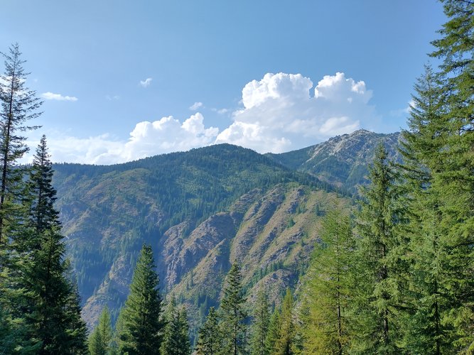
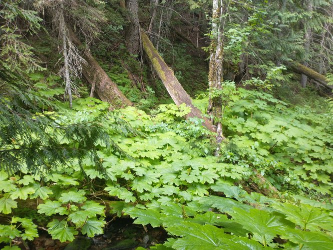
Here some pics from backpacking down around there. If had the time I would love to spend 10 days down there in Sept with some pack animals. First pic is of Snow Peak in the background showing some steepness. Second pic is a creek bottom showing the devils club. We did see some elk sign, but a lot of ground with no sign at all. In the age of busy trails last summer we covered close to 30 miles and only saw 2 other people on the trails, but it was not hunting season.

And the trails you see on the map are minimally maintained and overgrown the further you get from the trailheads and some you won't be able to find at all.

snow peak.jpg


devils club.jpg
 
Almost a repeat of my 2018 post, but I have spent more time down there but not hunting.

Not many hunters in unit 9 but most would be coming from the same access points you are looking at. The green patches on south facing slopes are usually not glassable meadows, most of them are covered with 6-8 ft tall ceanothus, serviceberry, elderberry, alders, rocky mountain maple, etc. If you're lucky it will be 4 ft tall ferns. If you are going to drop down and climb up to a spot, look at topo lines and satellite imagery closely. Climbing with 1,500+ ft of elevation over 1 mile and thick brush could end up taking hours. A lot of the lower parts of the canyons are 1k ft in <1/2 mile.

Here some pics from backpacking down around there. If had the time I would love to spend 10 days down there in Sept with some pack animals. First pic is of Snow Peak in the background showing some steepness. Second pic is a creek bottom showing the devils club. We did see some elk sign, but a lot of ground with no sign at all. In the age of busy trails last summer we covered close to 30 miles and only saw 2 other people on the trails, but it was not hunting season.

And the trails you see on the map are minimally maintained and overgrown the further you get from the trailheads and some you won't be able to find at all.

View attachment 169682


View attachment 169683
THANK YOU! This is fantastic. I've read it was thick, but these pictures are worth 10K words. Planning a scouting weekend this spring. I know the growing season will just be beginning, maybe. Will definitely keep in mind that everything we see will probably be covered in 6 feet of growth in October.
 
Almost a repeat of my 2018 post, but I have spent more time down there but not hunting.

Not many hunters in unit 9 but most would be coming from the same access points you are looking at. The green patches on south facing slopes are usually not glassable meadows, most of them are covered with 6-8 ft tall ceanothus, serviceberry, elderberry, alders, rocky mountain maple, etc. If you're lucky it will be 4 ft tall ferns. If you are going to drop down and climb up to a spot, look at topo lines and satellite imagery closely. Climbing with 1,500+ ft of elevation over 1 mile and thick brush could end up taking hours. A lot of the lower parts of the canyons are 1k ft in <1/2 mile.

Here some pics from backpacking down around there. If had the time I would love to spend 10 days down there in Sept with some pack animals. First pic is of Snow Peak in the background showing some steepness. Second pic is a creek bottom showing the devils club. We did see some elk sign, but a lot of ground with no sign at all. In the age of busy trails last summer we covered close to 30 miles and only saw 2 other people on the trails, but it was not hunting season.

And the trails you see on the map are minimally maintained and overgrown the further you get from the trailheads and some you won't be able to find at all.

View attachment 169682


View attachment 169683
Looks brutal but damn it's beautiful I'll make it up there one day
 
i dunno exactly where you are scouting in the spring, but many places are not accessible due to snow. Place we hunt I can not get in until early July to mid July due to snow
 
i dunno exactly where you are scouting in the spring, but many places are not accessible due to snow. Place we hunt I can not get in until early July to mid July due to snow
Very good point. If this La Nina Winter continues we might get lucky. Otherwise, our only glassing spots might be the snowplow mounds on the side of the roads!
 
Closest that I know of is the Grandmother Mountain WSA
Yep, still no Wilderness north of Hwy 12 in ID. But some of the roadless areas are significant. Between Snow Peak WMA, Mallard Larkins Pioneer area and surrounding roadless area the whole roadless area is 260k+ acres.


I have thought that a fun summer fishing trip would be rafting down the Little North Fork of the Clearwater. Years ago it probably would have been a rafting hunt trip option.
 
I have thought that a fun summer fishing trip would be rafting down the Little North Fork of the Clearwater. Years ago it probably would have been a rafting hunt trip option.
Your challenge might be having enough water for passage, but still good fishing. I've fished portions of it. It's a cool river.
 
Your challenge might be having enough water for passage, but still good fishing. I've fished portions of it. It's a cool river.
I used to take my boys in to Lost Lake every summer. The fishing there is hot or cold. The crawdadding is world class.
We bumped into Patrick McManus there once. My boys were gobsmacked.

Another great kids trip is camping where the Little North Fork hits slack water at Dworshak. Easy catching for the kids casting upstream. Its a deep channel so not too many snags.

Some blame IDFG for the lack of game in units 7 and 9. There was a savage winter kill in 1996/1997. A buddy and I hunted the late Muzzy hunt in unit 7 at Red Ives in 1997.
All the old timers we met said, "You should have been in here last year...."

I was backpacking NW of Grandmother in September 2020. If you are willing to go into the soup to get them, there are bulls in there. You won't go too far before you start thinking that they will never find your bones. I pitched up on the edge of a burn and had elk come in at night.
 

Latest posts

Forum statistics

Threads
113,683
Messages
2,029,628
Members
36,284
Latest member
Mtelkhunter119
Back
Top