GoHunt vs. OnX

I tend to agree with the consensus so far. I tried GoHunt last year and actually really liked it for planning our out-of-state hunt because of the research tools and also for the desktop functionality. I liked the 3D, elevation bands, aspect tools etc. but agree with others that OnX seemed to work better in the field. Can't really justify keeping both so I just stuck with OnX for hunting in my home state and like others have said, easier to share data with friends since most seem to have OnX.
 
I had some time invested with on-X by the time Gohunt came out with maps. Just as I had more time invested in Research on Go Hunt. I'm using both currently. i have the onX app on my phone.
 
I am with everyone on this.. OnX for me. The slight burr in my saddle with GoHunt is they will bill you without notice at no discount. OnX gives me a heads up when my subscription is about to expire and allows me to use any discount available.
I canceled my GoHunt subscription and not sure if I will renew for application strategy next year or not.

Check out Top Rut through onX.
 
Another vote for OnX on the mapping side and GoHunt on the research side.

If I could have only one it would be a tough decision.
 
I use gohunt maps because I use my brothers account(he pays for both and uses onyx for mapping). Can’t go wrong with free 😂
 
I have both but prefer OnX. I did have an issue with OnX this last week where the area I was hunting only partly had a topo map. It forced me switch back and forth between OnX and Gohunt maps on the hunt which made me glad to have both.
 
I'm a huge fan of GoHunt and use their research tools/read their website articles daily. That said, their map app was a disaster last year. I tried it after getting it free with my Insider subscription. In one video announcing the release, one of the guys (Brody maybe?) touts the ability to download maps that will cover entire units without the need to patchwork maps together. That simply isn't the case. I would try to download several maps, one at a time, and invariably the download would freeze and fail. I'd have to delete everything and start back fresh. When I finally did get some of the maps to download, they often wouldn't show up when operating offline. Finally, the location services were sporadically wildly off-- at times up to a mile from the landmark I was standing at. That could really get someone sideways if relying on it to pick up an unmarked public/private boundary. OnX's location was spot on.

I'm inclined to give GoHunt one more try this year but I foresee myself switching back to OnX eventually. Would be nice to see someone at GoHunt address the concerns made known on this thread. I know @Dave@gohunt is frequently on these boards, hopefully he will chime in.

Postscript: I should add that Nate Bare on the GoHunt staff went above and beyond trying to help me through the sticking download issue. He even returned a call to me *while on a mule deer hunt*. GoHunt's customer service is world class... their map app, not so much.
 
Onx all the way

Top rut is good enough for research
haven't tried go hunt.

plan to stick with onx indefinitely. lots of way points and tracks that, sure, i could transfer but who wants to deal with that when onx works great? and it does work great.

toprut is good enough to help narrow down your research to a half dozen units to hone in for in depth research on your own. that it doesn't cost me extra means it's a pretty decent service to have.

onx is solid IMO. if it was clearly lacking something i would look into switching, but i'm yet to see how it's lacking.
Agreed

Onx all the way

I too like to zero in on a handful of units then do the analysis for myself with the state provided data
 
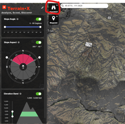
I just upgraded to Elite in OnX. Those new tools are incredible. The slope exposure and elevation bands are cool but the View Shed tool is the best in my opinion. My GoHunt subscription is good til March of 2024 so I'll have a little time to play with the Top Rut and consider going strictly back to OnX.
 
On a computer, I think GoHunt wins but on a phone / in the field OnX has the clear advantage.

For the most part I only use OnX unless I have a certain terrain analysis I need to run or when I want to know if I have an unobstructed view (a feature only GoHunt has). Then I create a waypoint and move just that one waypoint to OnX after confirming.
 
I'm a huge fan of GoHunt and use their research tools/read their website articles daily. That said, their map app was a disaster last year. I tried it after getting it free with my Insider subscription. In one video announcing the release, one of the guys (Brody maybe?) touts the ability to download maps that will cover entire units without the need to patchwork maps together. That simply isn't the case. I would try to download several maps, one at a time, and invariably the download would freeze and fail. I'd have to delete everything and start back fresh. When I finally did get some of the maps to download, they often wouldn't show up when operating offline. Finally, the location services were sporadically wildly off-- at times up to a mile from the landmark I was standing at. That could really get someone sideways if relying on it to pick up an unmarked public/private boundary. OnX's location was spot on.

I'm inclined to give GoHunt one more try this year but I foresee myself switching back to OnX eventually. Would be nice to see someone at GoHunt address the concerns made known on this thread. I know @Dave@gohunt is frequently on these boards, hopefully he will chime in.

Postscript: I should add that Nate Bare on the GoHunt staff went above and beyond trying to help me through the sticking download issue. He even returned a call to me *while on a mule deer hunt*. GoHunt's customer service is world class... their map app, not so much.
Exact like you and a huge fan of GOHUNT as well but have experienced the exact same issues, which was frustrating and taking time away from hunting. I as well really hope they figure it out and will give them another season to figure it out.
 
On a computer, I think GoHunt wins but on a phone / in the field OnX has the clear advantage.

For the most part I only use OnX unless I have a certain terrain analysis I need to run or when I want to know if I have an unobstructed view (a feature only GoHunt has). Then I create a waypoint and move just that one waypoint to OnX after confirming.
I think the view shed tool in OnX Elite does this for you now.
 
Hey everyone, this has been an excellent thread. I have been watching it since it started but have been hesitant to jump in as I was largely afraid it would deter some from giving brutally honest feedback. It looks like things are starting to ebb some so I wanted to step in, now.

As I said, there has been some excellent feedback in this thread around stuff that we are definitely aware of. This past winter/spring we have been working extremely hard on improving app reliability and functionality. There are a lot of us here at the office that hunt, obviously, and we dealt with the same frustrations as noted in this thread so we are hearing this loud and clear!

We've recently improved our publishing ability which makes it easier and quicker for us to implement layer changes, like the Access Yes properties in Idaho as mentioned above. Along with this, we've done a bunch of cartography(styling) changes and have some new features coming out that I'm really excited about. We also recently launched historical imagery(web only) which has been great. Downloads and download speeds are improving and app stability and accuracy have improved dramatically. I personally use an iOS device and this has been nearly flawless lately.

Hands down two of the biggest issues we had this past season were location(GPS Accuracy) and offline map downloads/performance and I'm happy to say that both of these have been almost entirely squashed.

Please don't let my presence hinder any feedback, we like to hear it. Thank you, everyone!
 
Kenetrek Boots

Latest posts

Forum statistics

Threads
113,668
Messages
2,029,000
Members
36,276
Latest member
Eller fam
Back
Top