E-scouting help: game-trails vs. horse-trails/hiking trails

dmarsh2

Member
Joined
Mar 13, 2019
Messages
44
I've been doing a great deal of e-scouting the unit I've been thinking of elk-hunting this fall.. I'm intending to target wilderness to try and reduce my run-ins with other hunting parties, and I've learned (on here, I believe) that horseback groups can sometimes be doing the same thing, but more effectively.. to avoid this on foot, look for areas that are lacking horse-trails. My question is this: will elk move about this landscape in a linear fashion and create these same game trails? and will these be as discernible on google earth as a hiking / horse trail?

I'm used to whitetails in the Midwest, who can sometimes wear heavy trails into the forest floor, making their travel patterns highly predictable (when they're travelling is usually the issue though).

So, am I looking at heavy usage trails in the area? or am I seeing places where elk may be moving?
 
My question is this: will elk move about this landscape in a linear fashion and create these same game trails? and will these be as discernible on google earth as a hiking / horse trail?

I'm used to whitetails in the Midwest, who can sometimes wear heavy trails into the forest floor, making their travel patterns highly predictable (when they're travelling is usually the issue though).

So, am I looking at heavy usage trails in the area? or am I seeing places where elk may be moving?

I am no expert on e-scouting but have done my fair share over the years (some successful & some not) and it is extremely helpful, specially if you have a fair amount of hunting experience with the game animals your scouting for. The more knowledge you already have about the habits of the specific game your hunting can really help focus in on specific areas.

It is very difficult to discern Elk trails vs deer vs. free range cattle and so on in Google earth. Given a known Elk game reserve or something like that close by you can assume the trails are primarily Elk. Elk will often travel in single file even in large herds. Most often the trails you see on google earth are pounded in over years of continuous use by game animals. What these pounded trails can tell you on google earth is corridors of travel. The key is to put your boots on the ground and find out where those well pounded trails lead (bedding, water, food sources, mineral sources, dens and so on). E-scouting can only do so much in the way of giving you "clues" as to being a viable area to check out. If your primary hunt style is ambush and you hunt a time of year that supports that style of hunting the well pounded game trails can be a place to start. I must stress that boots on the ground and game cameras are your best friend. Trails can be used heavily for 1 or 2 months (look like highways on google earth) then go dormant for the rest of the year. Take for instance mineral sources. Elk will hit them with absolute clock work and regularity early in the year as they come off winter and then not even bother with them for the entirety of the rest of the year. Food sources are similar. As the food goes away the Elk will move on. Other things that can change behavior aside from time of year is pressure (hunt pressure, vehicles and people in particular). Many reasons hunters try and find an edge by getting out past the crowds or finding an area that is difficult to get into is to alleviate the hunt pressure scenario from the many scenarios that play into why animals are in a certain area at a certain time of year.

As far as designated foot trails, ATV, Horseback or other it's always nice to pair your e-scouting with an application like Basemap or OnX maps. All that hard work has been done for you and set into overlays that can be EXTREMELY helpful in determining access and egress to a hunting area.

Hopefully this helps some and doesn't muddy the waters.
 
Last edited by a moderator:
I am no expert on e-scouting but have done my fair share over the years (some successful & some not) and it is extremely helpful, specially if you have a fair amount of hunting experience with the game animals your scouting for. The more knowledge you already have about the habits of the specific game your hunting can really help focus in on specific areas.

It is very difficult to discern Elk trails vs deer vs. free range cattle and so on in Google earth. Given a known Elk game reserve or something like that close by you can assume the trails are primarily Elk. Elk will often travel in single file even in large herds. Most often the trails you see on google earth are pounded in over years of continuous use by game animals. What these pounded trails can tell you on google earth is corridors of travel. The key is to put your boots on the ground and find out where those well pounded trails lead (bedding, water, food sources, mineral sources, dens and so on). E-scouting can only do so much in the way of giving you "clues" as to being a viable area to check out. If your primary hunt style is ambush and you hunt a time of year that supports that style of hunting the well pounded game trails can be a place to start. I must stress that boots on the ground and game cameras are your best friend. Trails can be used heavily for 1 or 2 months (look like highways on google earth) then go dormant for the rest of the year. Take for instance mineral sources. Elk will hit them with absolute clock work and regularity early in the year as they come off winter and then not even bother with them for the entirety of the rest of the year. Food sources are similar. As the food goes away the Elk will move on. Other things that can change behavior aside from time of year is pressure (hunt pressure, vehicles and people in particular). Many reasons hunters try and find an edge by getting out past the crowds or finding an area that is difficult to get into is to alleviate the hunt pressure scenario from the many scenarios that play into why animals are in a certain area at a certain time of year.

As far as designated foot trails, ATV, Horseback or other it's always nice to pair your e-scouting with an application like Basemap or OnX maps. All that hard work has been done for you and set into overlays that can be EXTREMELY helpful in determining access and egress to a hunting area.

Hopefully this helps some and doesn't muddy the waters.

Thanks ntodwild, that's helpful insight. I do plan on getting boots on the ground, I'm just trying to narrow down the field of potential places I go to scout, and was just hesitant when I saw a pretty heavily warn trail alongside a slope, and wondered the odds it would be game or not.

I haven't heard of Basemap before, but OnX, the atlas, and a few other mapping softwares are my primary tools, in addition to cross-referencing previous year data regarding draws and harvest. Thanks for the input

Good luck to you in your scouting. I will cross my fingers for you and hope you land your first elk (not sure if it's your first elk hunt but sounds like it might be?) As a side bar, I would say trust your instincts about an area you e-scout. More often than not you will find some kind of educational tidbit even if it doesn't pan out you will learn something.
 
Good luck to you in your scouting. I will cross my fingers for you and hope you land your first elk (not sure if it's your first elk hunt but sounds like it might be?) As a side bar, I would say trust your instincts about an area you e-scout. More often than not you will find some kind of educational tidbit even if it doesn't pan out you will learn something.

ntodwild I appreciate it, thanks very much.

Yes, this will be my first elk hunt.. Trying to prepare as much as I can - scouting, reading up on the species, reviewing past-years of statistics, just trying to be a sponge. Hopefully with another set of crossed fingers I'll be able to seal the deal.
 
My experience is that most horse hunters want to be in a min. of 5 miles +/-, and depending on the area you are hunting, they will go 5-10-15 miles in.

If you are a hiking hunter, then you will avoid most people by hunting in the 2 to 5 mile range, most horse guys are looking to go beyond the 2 miles. and if it's a lot of vertical and rugged you will eliminate those people that aren't willing to work hard at it.

Don't overthink it, good luck.
 
Trails can be tough to decipher, but if you take all of the available info you can get a pretty good clue. Knowing about livestock use in the area you're e-scouting can make a difference, but remember that historic use may be very different than current and the trails you see might be 20 years old depending on the ecosystem elevation/productivity. Also, deer, elk, and moo cows can and do use the very same trails at times so that confounds the issue. Once you start seeing animals you'll get a feel for it.
 
I am no expert on e-scouting but have done my fair share over the years (some successful & some not) and it is extremely helpful, specially if you have a fair amount of hunting experience with the game animals your scouting for. The more knowledge you already have about the habits of the specific game your hunting can really help focus in on specific areas.

It is very difficult to discern Elk trails vs deer vs. free range cattle and so on in Google earth. Given a known Elk game reserve or something like that close by you can assume the trails are primarily Elk. Elk will often travel in single file even in large herds. Most often the trails you see on google earth are pounded in over years of continuous use by game animals. What these pounded trails can tell you on google earth is corridors of travel. The key is to put your boots on the ground and find out where those well pounded trails lead (bedding, water, food sources, mineral sources, dens and so on). E-scouting can only do so much in the way of giving you "clues" as to being a viable area to check out. If your primary hunt style is ambush and you hunt a time of year that supports that style of hunting the well pounded game trails can be a place to start. I must stress that boots on the ground and game cameras are your best friend. Trails can be used heavily for 1 or 2 months (look like highways on google earth) then go dormant for the rest of the year. Take for instance mineral sources. Elk will hit them with absolute clock work and regularity early in the year as they come off winter and then not even bother with them for the entirety of the rest of the year. Food sources are similar. As the food goes away the Elk will move on. Other things that can change behavior aside from time of year is pressure (hunt pressure, vehicles and people in particular). Many reasons hunters try and find an edge by getting out past the crowds or finding an area that is difficult to get into is to alleviate the hunt pressure scenario from the many scenarios that play into why animals are in a certain area at a certain time of year.

As far as designated foot trails, ATV, Horseback or other it's always nice to pair your e-scouting with an application like Basemap or OnX maps. All that hard work has been done for you and set into overlays that can be EXTREMELY helpful in determining access and egress to a hunting area.

Hopefully this helps some and doesn't muddy the waters.
Pretty much spot on.
A new elk trail can show up here in a week when they are pressured from traditional paths. Path of least resistance.....
Cattle use elk trails here cross country or up & down mesas & mountains. Trails along fencelines are usually cattle paths.
Old game trails will get reused when the grass is greener in spots or water is present & show up more.
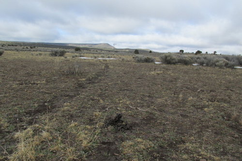
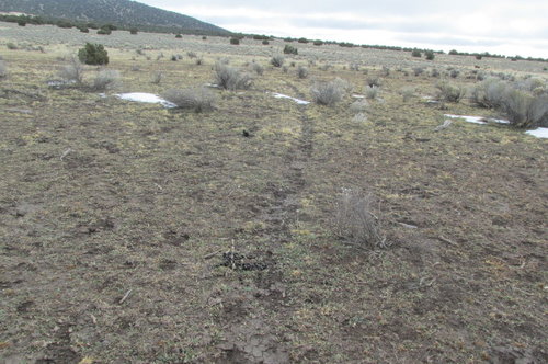
This pic is of elk trail facing away from my well in distance & tank to opposite corner of property where they cross the fence to the bedding grounds on mesa behind me. It turns into a trough during summer months from use. IMG_0027.JPGIMG_0026.JPG
That is a big bull turd from really big bull......mid winter & fresh.
 
Thanks for the real-life images, pretty useful to see.

I appreciate all the input everyone!
 
Kenetrek Boots

Forum statistics

Threads
113,675
Messages
2,029,334
Members
36,279
Latest member
TURKEY NUT
Back
Top