Ask your onX Hunt questions here!

The above was from my laptop.

I tried the same from my phone, Samsung S20:

This is the result:

#1
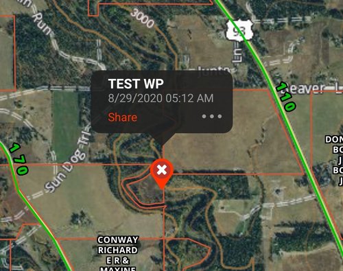
Screenshot_20200829-051440_onX Hunt.jpg

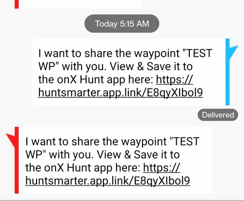
#2 Text to myself

Screenshot_20200829-051707_Message+.jpg

#3 Result:

Screenshot_20200829-051610_onX Hunt.jpg

I tried sending this two additional times with the same results. I then made a completely new waypoint and received the same response. Appreciate your assist @onX Hunt
 
The above was from my laptop.

I tried the same from my phone, Samsung S20:

This is the result:

#1

View attachment 152182

#2 Text to myself

View attachment 152183

#3 Result:

View attachment 152184

I tried sending this two additional times with the same results. I then made a completely new waypoint and received the same response. Appreciate your assist @onX Hunt

First ensure you have the most updated version of the app on any devices that you are sharing to. Could you also give us a call at 406-540-1600 so we can gather more information, I want to make sure we understand what you are doing so we can accurately get you up and running. I am a bit confused on the screenshots from your first example as the waypoint is not showing on your map as if you did not click on the shared link.
 
This is another reason why OnX keeps my business. Called, discussed the issues in greater detail and they dig in to assist as best possible.

Side note:
#1 issue: Sharing location from >>> to the same account will cause errors.

They are looking into another issue and will get back once they dig in a bit further. I wish other companies managed their service in this fashion...

Hats off OnX. Thanks for your assist.
 
Having issue with my waypoints being visible on the app map. I set the waypoints in the computer browser version. After I install the app on my phone and I sync the contents to the app, all of my waypoints are visible. After I sync a second time, they disappear on the map. I can't get them to appear without going into each waypoint and hitting the "view/edit" option in the app. I have to do that individually for each waypoint to get them to show up on the map again no matter if I have them check marked or not. I even uninstalled the app and reinstalled but got the same results. @onX Hunt
 
Last edited:
I was told by one of your employees at an event in Bozeman during the summer of 2018 that we would be able to select both the resolution and size of our offline maps by that fall (ie. 10 mile width at high resolution, etc). Is this something that is coming?
 
Also, for the last month or so the roadless layer is only appearing about 50% of the time I use the web app. I'm using Chrome and sometimes I can get it to reappear by refreshing the page a number of times.
 
Alright experts. My tablet won't let me add anymore offline maps since I have used up all my space. I want to delete some saved offline maps, but I didn't name the maps, so I am shooting in the dark to remove saved maps I don't use. Is there an easy was to identify these maps to delete?
 
I was told by one of your employees at an event in Bozeman during the summer of 2018 that we would be able to select both the resolution and size of our offline maps by that fall (ie. 10 mile width at high resolution, etc). Is this something that is coming?
We are working on more offline maps options but we do not have any timetable on when it will be available. Thanks for the feedback, I'll bring that up to our team as we continue to improve that.

As for the roadless layer, we have not been hearing issues with it. I'd suggest clearing your browser data/cache as that could be causing that. Additionally, make sure you have the most updated version of chrome as well.
 
Alright experts. My tablet won't let me add anymore offline maps since I have used up all my space. I want to delete some saved offline maps, but I didn't name the maps, so I am shooting in the dark to remove saved maps I don't use. Is there an easy was to identify these maps to delete?

First, go into the Map Settings section (by tapping the 3 lines in the upper left hand corner) then find the "Show offline map outlines" button and toggle that on so it shows the boxes on your map. Then if you go into your Offline Maps tab and tap on the name (date and time if you didn't give them a special name) and the map will center on that map. Then if that is one you want to remove, tap the 3 dots next to the map and delete it from there.
 
First, go into the Map Settings section (by tapping the 3 lines in the upper left hand corner) then find the "Show offline map outlines" button and toggle that on so it shows the boxes on your map. Then if you go into your Offline Maps tab and tap on the name (date and time if you didn't give them a special name) and the map will center on that map. Then if that is one you want to remove, tap the 3 dots next to the map and delete it from there.
Copy. I have maybe 40 or 50 maps and wanted to delete a couple random ones that were scattered across the state. I was hoping there was an option to <click> on the “green” box to get info that would make it easier to locate, like a date saved. Now I know that doesn’t exist, so I will just have to remember to attach a name so it is easily recalled for me. Thanks for responding.
 
I am having problems in offline maps with the public layers showing up at varying levels of zooming in. This happens in many areas of the downloaded maps I have.

One example is attached. Same area just different zoom levels. Any ideas?
 

Attachments

  • 20200913_075753.jpg
    20200913_075753.jpg
    400.3 KB · Views: 9
  • 20200913_075729.jpg
    20200913_075729.jpg
    338.9 KB · Views: 9
I am having problems in offline maps with the public layers showing up at varying levels of zooming in. This happens in many areas of the downloaded maps I have.

One example is attached. Same area just different zoom levels. Any ideas?

Based on the size of various parcels of land, they do load at different zoom levels. If you are zoomed out far, since the underlying map would not be able to register where those boundaries are, they do not populate until you zoom in closer.
 
Based on the size of various parcels of land, they do load at different zoom levels. If you are zoomed out far, since the underlying map would not be able to register where those boundaries are, they do not populate until you zoom in closer.


Support was able to help me get it fixed, seems to be working now.
 
Back
Top