Navigation
Install the app
How to install the app on iOS
Follow along with the video below to see how to install our site as a web app on your home screen.
Note: This feature may not be available in some browsers.
More options
You are using an out of date browser. It may not display this or other websites correctly.
You should upgrade or use an alternative browser.
You should upgrade or use an alternative browser.
Ask your onX Hunt questions here!
- Thread starter Big Fin
- Start date
I agree 100%I thought that was just me. If I'm trying to use OnX on my computer it's so slow. And God forbid I try and use Google maps at the same time.
using Chrome (on a Mac primarily but also on my Windows 10 work machine), the OnX web version is effectively unusable for me. (And on the Mac, Edge is not an option). Just zooming out, the map takes 10-15 seconds to paint and I am not able to smoothly zoom out so it has to be done in stages, then recentering and zooming back in takes the same across similar small steps.
@onX Hunt - any thoughts on this? I would generally prefer to do a lot of my detail work at home and use the mobile app in Offline mode on the field but I am effectively resigned to the phone for everything.
Straight Arrow
Well-known member
"Airplane" mode?It might be battery saving mode. If I have my phone set to save battery at all it won't track in the background.
TakeABreakAndTouchGrass
Well-known member
- Joined
- Sep 19, 2016
- Messages
- 3,286
"Airplane" mode?
That doesn't seem to be a problem. Just if I turn on battery saver. Even in airplane mode the battery drains pretty quick if you're actually tracking yourself. Definitely won't last all day.
WapitiBob
Well-known member
Battery saver and not tracking was an issue a while back for both onx and basemaps. I believe there is a phone setting for it but I don’t recall what it is. My iPhone tracks when in sleep mode.
I use chrome and edge and have not seen any lag in my onx web map.
The fix for map layers not showing on iPhone is to delete the maps, unfortunately. I just deleted the app as it was easier. I then installed onx and downloaded new maps; user data isn’t affected and will sync with the web side. The problem should not repeat if you are on the latest onx version.
onX Hunt
Active member
- Joined
- Jul 22, 2013
- Messages
- 434
Is it possible to organize waypoints into folders? Say I have a hunt area that I want to populate for early fall, but also late rifle, but don't want the clutter of tracks and waypoints from a different season- just select a folder to turn off all at once?
More organization with your content is coming in the near future so stay tuned!
onX Hunt
Active member
- Joined
- Jul 22, 2013
- Messages
- 434
Also, is there a way to toggle waypoints on and off? I have enough in certain areas where they kind of crowd out the other features of the map when zoomed out far enough.
Yes there is, go into the My content section of the app and you can tap the little check box to turn off various waypoints, shapes, tracks, etc.
Again more customization is coming to this section so you can easily organize and toggle of waypoints for different hunts.
onX Hunt
Active member
- Joined
- Jul 22, 2013
- Messages
- 434
Did you happen to take a screenshot of what was occurring? That will give us a better idea of what is happening. Feel free to give us a call at 406-540-1600 and we can walk through a few things.Last weekend while out hunting I was using the offline map and a portion of one of my online map was very blurry and I couldn’t see that section of the offline map. What could this be?
onX Hunt
Active member
- Joined
- Jul 22, 2013
- Messages
- 434
I second the issue with downloaded offline layers not loading (or being ‘blurry’) unless you eventually hit some service. That has been my main issue for years and 90% of my usage is when I’m out of service on downloaded offline maps (v20.32.0) - it clears up when following the steps outlined above but it’s frustrating.
Also - recently (last 3-6 months) I’ve noticed that if I start OnX in offline mode, the ‘Upgrade’ button appears in the lower left hand corner (app thinks I am a basic user). It appears there when You start it in online mode too, but I can simply click on my profile and it “catches up” that I have the Elite membership, but offline - the red button stays on the lower left hand corner and I am thinking it might be causing some of the ‘blurry’/non-loading layers in my downloaded maps as it seems to think I am a basic member until I hit service and refresh.
We have not heard of this occurring, could you please give us a call at 406-540-1600 or email [email protected] so we can gather more information from you?
onX Hunt
Active member
- Joined
- Jul 22, 2013
- Messages
- 434
Do I just have to update my app? Then I can see the new stuff? Same price?
Updating your app does not charge you anything additional and gives you all the latest features and information that we currently have. You will update the app through the App or Google Play store.
Lyfter1013
Well-known member
- Joined
- Mar 11, 2020
- Messages
- 614
I just put my phone to airplane mode and recreated the problem.. should I send them via private message on here?Did you happen to take a screenshot of what was occurring? That will give us a better idea of what is happening. Feel free to give us a call at 406-540-1600 and we can walk through a few things.
Oldskool67
Member
- Joined
- Jun 20, 2017
- Messages
- 29
Are you going to produce chips for the new Garmin Montana 700 / 750i GPS ?
Scott85
Well-known member
- Joined
- Nov 22, 2018
- Messages
- 3,162
Do trails shown on private land in the app have easement for the public to hike on?
Jmnhunter
Active member
When will OnX update the MN layers, its been over a year since its been updated (private parcels atleast)!
onX Hunt
Active member
- Joined
- Jul 22, 2013
- Messages
- 434
Do trails shown on private land in the app have easement for the public to hike on?
This will vary depending on your state and the trail you are hiking on as there are various rules regarding this so check with your local regulations.
onX Hunt
Active member
- Joined
- Jul 22, 2013
- Messages
- 434
When will OnX update the MN layers, its been over a year since its been updated (private parcels atleast)!
We have updated a handful of counties recently for MN and are continually updating our information.
We work with the counties as well as state/federal agencies on obtaining our information so we reflect what they have in their digitized system so you will want to verify they have the correct information in their system as that is where we obtain the data that is in the app. We have implemented new systems that will allow us to update more frequently to catch those changes.
WapitiBob
Well-known member
WapitiBob
Well-known member
VikingsGuy
Well-known member
Looks like a little competition is a good thing!
Question about the share function... I placed sample snips to pattern my actions.
#1 Placed a marker labeled as below, "Share Test Location 48.05337, -114.32112"
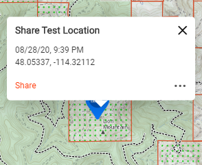
#2 Clicked share and received the prompt below.
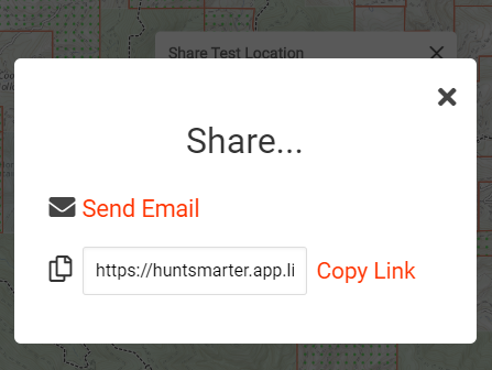
#3. Copied Link provided
https://huntsmarter.app.link/tGqrRZRRk9
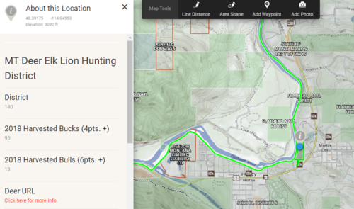
#4. Placed in email and clicked the copied link. This brought up the following screen clip. You can see the "i" at the bottom right area. This is due to clicking on the blue dot.
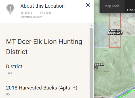
The information provided by the copied link brought me to the following coordinates (Enlarged screen clip from the above clip) 48.39175 -114.04553:
What am I doing wrong? I intend to send the real information (Not this sample) to my hunt partner so he knows where to meet and the area for archery though it's not matching my location.
Thanks for your help. @onX Hunt
#1 Placed a marker labeled as below, "Share Test Location 48.05337, -114.32112"

#2 Clicked share and received the prompt below.

#3. Copied Link provided
https://huntsmarter.app.link/tGqrRZRRk9
#4. Placed in email and clicked the copied link. This brought up the following screen clip. You can see the "i" at the bottom right area. This is due to clicking on the blue dot.

The information provided by the copied link brought me to the following coordinates (Enlarged screen clip from the above clip) 48.39175 -114.04553:

What am I doing wrong? I intend to send the real information (Not this sample) to my hunt partner so he knows where to meet and the area for archery though it's not matching my location.
Thanks for your help. @onX Hunt


