Hunt Talk Radio - Look for it on your favorite Podcast platform

Threat to Wyoming migration

Yikes... so something about this just didn't sit right with me last night so I googled a bit.

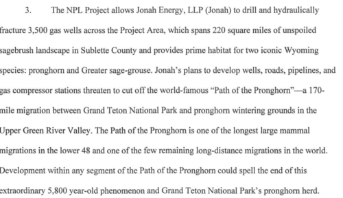
This is the project the article links to, it's one project and one company Jonah energy.
1582732258569.png

The project is billed as 3,500 wells... first off that is flat out BS, yes that's what it's billed as but that is pure OG BS.
This project is 227 sections which means 15 wells per section if drilled on a 1 mile basis or 30 wells if drilled on a two mile basis.

Let's say Jonah managed to get costs down to $1,000,000 (yeah right) a well... that's $3,500,000,000. At the very most their drilling budget is $250,000,000 (not in this market it isn't)

Currently Jonah is barely drilling, maybe running 1 rig, I would guess at most 20 wells a year, so at current rates it would take 175 years to drill these wells.

Article discussing Jonah and it's basin entry from 2017
1582733784519.png

We are sitting at $1.83 gas and $50 oil and this is billed as mainly a gas project.


For some perspective there have been 9,000 wells drilled in Oklahoma in the last 10 years, that's everyone... even big public ops like continental who were running 20+ rigs at a time.
Oklahoma produces more than double the oil and gas that Wyoming does.
 
Last edited by a moderator:
The Jonah project if fully develop will likely be 113 pads (possibly half that) at 4 acres a pad... so ~450, and as I said will take decades to build out, if full development happens at all which is extremely unlikely. I think at most we see 20-50 acres of surface use.

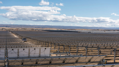
For perspective this is the Sweetwater project, which is just down the road. 703 acres of surface use. This project actually blocked pronghorn winter migration and sent the entire herd into the highway. This isn't a speculation on what could happen as is the Jonah project, this happened this winter.

1582736023495.png1582735976168.png
 
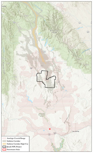
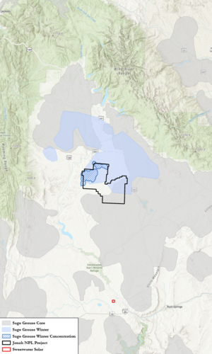
Here is a quick reference map of the discussion area.
AntelopeMigration.jpg
 
Here is a quick reference map of the discussion area.
View attachment 129273
Another solar project planned for just a few miles south of Sweetwater Solar. Another 400 acres of public land disturbance in ACR.

 
Well sites don't inhibit migration, fences do. Right now as I write this, antelope are stacking up against fences in central Wyoming and dying.
Are those fences built around a gas well, coal mine or uranium project? If not then nothing to see here, move along.
 
I have spent a good deal of time in the NPL for the express purpose of water, habitat, and general vegetation inventory (and plenty of off-time recreation as well). As in many weeks of field work. As it is likely to be developed, that particular project would not concern me substantially in terms of impacts to seasonal habitat or migration for big game relative to many other projects. The biologists for that field office are well aware of the full picture. That's about all I'll say publicly, anyone is welcome to PM.
 
Just so I have this correct; are you stating wells, roads and associated infrastructure are beneficial to pronghorn?
 
Relevant map

I have spent a good deal of time in the NPL for the express purpose of water, habitat, and general vegetation inventory (and plenty of off-time recreation as well). As in many weeks of field work. As it is likely to be developed, that particular project would not concern me substantially in terms of impacts to seasonal habitat or migration for big game relative to many other projects. The biologists for that field office are well aware of the full picture. That's about all I'll say publicly, anyone is welcome to PM.

Thanks, SnowyMountaineer - I'm following this with high interest - I've been involved with 3 pronghorn hunts and a couple of deer and elk hunts on that map (and my only personal WY pronghorn was taken about dead center of the map - based out of best friends families homestead cabin which is also about centered on the map).
 
To be clear I wasn't suggesting the project wouldn't happen, simply that the scale of the project would be a fraction what was reported.
By italicizing "likely", I just mean there's no way to know for sure what the level of development will be, but there's a range of outcomes that are most likely. I tend to agree with you on the scale.
 
Thanks, SnowyMountaineer - I'm following this with high interest - I've been involved with 3 pronghorn hunts and a couple of deer and elk hunts on that map (and my only personal WY pronghorn was taken about dead center of the map - based out of best friends families homestead cabin which is also about centered on the map).
To be clear, I'm not saying there will be no impact. But when I look at how this project is likely to play out in concert with how big game use this specific chunk of ground and what's there in terms of predominant habitat types, there are many past and proposed developments that would be of greater concern to me. Grouse may be another matter.
 
By italicizing "likely", I just mean there's no way to know for sure what the level of development will be, but there's a range of outcomes that are most likely. I tend to agree with you on the scale.
But analysis "should" be done on "likely". I think we all agree on this.

Before we go further off track, did BLM analyse impacts to GSG and pronghorn? That is the question.
 
  • Like
Reactions: Oak
Use Promo Code Randy for 20% off OutdoorClass

Latest posts

Forum statistics

Threads
113,668
Messages
2,028,944
Members
36,275
Latest member
johnw3474
Back
Top