Ollin Magnetic Digiscoping System

Prove me wrong: Map data collection

I’m not convinced you could decipher clusters in a beneficial way. Again, do the clusters tell you where the elk are, or where the people are?
Spring elk sheds,
I absolutely could.

Sept elk,
To many variables I live in a unit with lots of miles between elk herds. I find them in the same spots over and over again. If they are not there I find the reason and use it to find them. (Hunting pressure, dry year, wet year, ect)
I also have a lot of spots pinned that aren't mine I have been trusted with info and am respectful of whoever shared it.
So it is guarded.
Also I don't think you know enough about me to have an opinion. Maybe you couldn't. I would be able to use the info.

I would like my onx locations protected with the utmost scrutiny. With that said I personally dont think they are doing anything nefarious.

Until you start posting specific locations with each hunt you are talking out both sides of your mouth with this argument.
 
This app has over a million users... this data is epically garbage and would be virtually impossible to QC.

About as good as you'd get would be stealing specific users points, which would mean exposing users passwords to fraudulently login as them or exposing keys that tie data tables to users. The former is gonna get you fired and the later if possible reflects some incredibly shitty db design/ security.
 
This app has over a million users... this data is epically garbage and would be virtually impossible to QC.

More data means you can get more specific with search and sort tools.

I need waypoints generated within 10mi radius for the last 10years between the days of 0ct15th to the 20th. On a drought year with daytime highs in the 50s.


Maybe onx will soon offer a platinum service where for $1000 a year we can access all users data.
You’re gonna get 800 points from dudes in Michigan bored in their deer stands E-Scouting, and there is no way to know what’s accurate and what’s not.

I’ve kinda done this with a dataset for a game animal, users even add pics and add annotations like number seen, gender, etc. You can search by month, zoom in on areas and see the points, etc. Everything you’re saying.

It’s only helpful if you have no clue what you’re doing. Like coming in totally cold to a state it lets you know oh there are actually xxxx animal here, but beyond that not that helpful. I got a couple of spots out of it but still had to hunt it and ended up killing a critter in a spot with no points anywhere near it.
 
More data means you can get more specific with search and sort tools.
False. GIGO. Garbage In Garbage Out.

The utility of the data is only as good as the quality. I would say across the whole spectrum of data collected as waypoints in OnX, even just in one given unit, the result would probably be less useful than just escouting it yourself on Google Earth. For every quality point, you probably have 100 that are pure garbage. Filtering and sorting garbage equals garbage.
 
You’re gonna get 800 points from dudes in Michigan bored in their deer stands E-Scouting, and there is no way to know what’s accurate and what’s not.
Maybe but the clusters should help narrow.
Again devils advocate here so.
Why can't we filter by local isp. Or by Whether or not the device was located in the area when the waypoint was generated.
 
So I think I'm more interested in the real time data. Let's say I'm hunting unit xx in state xx. The unit is big. I've done my research and I've found my 1st, 2nd and 3rd choice areas and not found elk or deer. If I have access to data from users in the field then I can change my location/tactics and approach. This includes elevation, specific drainages and areas of the unit. So let's say that someone is very active and uploaded multiple waypoints in a 2 day period. I'd be interested in their general area. Opposed to a person that uploaded only a few waypoints over a spread out area. This can also allow me to see where these hunters are approaching a drainage or knob from. So if I'm striking out on my 1st and 2nd options I have a live update on how other hunters are doing. Yes this seems wild and far fetched and I'm definitely not a tinfoil hat wearer but it's just an interesting concept to consider as more and more people upload data and they continue to promote their business. Filtering data is interesting. But live updates I think would be the most beneficial.
But the biggest issue with your statement above is that you're assuming the holder of said app / phone has service. I am not sure that is always true. so by the time something gets uploaded, the time frame doesn't work for analyzing said new waypoints.

At the end of the day, for ONE person to utilize the data above, they would have to create a team to dissect the data and then that same team or another team to create an algorithm to spit out probability and predictive data.

THEN assuming those teams can do that, said beneficiary then needs to get to the location

All the while the elk have moved and I can't tell you where because I only see elk when I am not hunting 🤣
 
False. GIGO. Garbage In Garbage Out.

The utility of the data is only as good as the quality. I would say across the whole spectrum of data collected as waypoints in OnX, even just in one given unit, the result would probably be less useful than just escouting it yourself on Google Earth. For every quality point, you probably have 100 that are pure garbage. Filtering and sorting garbage equals garbage.
I'm confused why would anyone be walking around the woods creating garbage waypoints unless they thought they would be compromised?

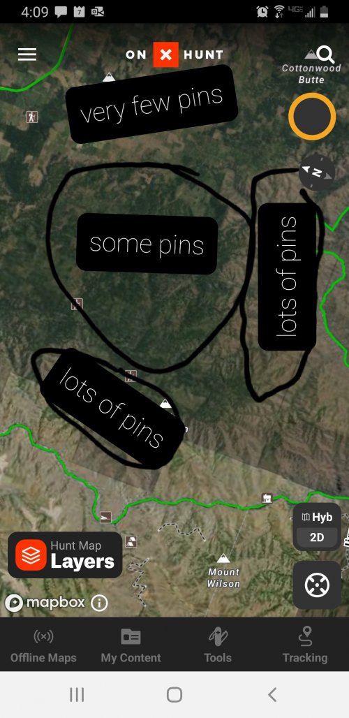
If you had a draw tag in a unit you had never hunted and had info for all of the pins of that species. I suspect there would be clusters in some units. Now if you filter them to meet your conditions where would you hunt?
20221107_161321.jpg
 
Last edited:
I'm confused why would anyone be walking around the woods creating garbage waypoints unless they thought they would be compromised?
well I have waypoints of where I want to focus my attention... and if you pulled up my go hunt now you'd think I saw a ton of elk. but thats just there so that my dumbass doesn't glass in the wrong direction... those "elk" waypoints would be considered garbage waypoints at this time.
 
well I have waypoints of where I want to focus my attention... and if you pulled up my go hunt now you'd think I saw a ton of elk. but thats just there so that my dumbass doesn't glass in the wrong direction... those "elk" waypoints would be considered garbage waypoints at this time.
Thats fair but if you cluster many peoples best guess together with real on the ground sightings its probably a dam good starting point.
 
But the biggest issue with your statement above is that you're assuming the holder of said app / phone has service. I am not sure that is always true. so by the time something gets uploaded, the time frame doesn't work for analyzing said new waypoints.

At the end of the day, for ONE person to utilize the data above, they would have to create a team to dissect the data and then that same team or another team to create an algorithm to spit out probability and predictive data.

THEN assuming those teams can do that, said beneficiary then needs to get to the location

All the while the elk have moved and I can't tell you where because I only see elk when I am not hunting 🤣
True on the phone service component. But I believe you're underestimating the ability to sort data in a rapid way with phones and computers. IF someone was savy and could apply filters to data in meaningful ways the search for points is remarkably easy and narrow.
 
I'm confused why would anyone be walking around the woods creating garbage waypoints unless they thought they would be compromised?

If you had a draw tag in a unit you had never hunted and had info for all of the pins of that species. I suspect there would be clusters in some units. Now if you filter them to meet your conditions where would you hunt?
View attachment 248826
For just one unit that comes to mind, I personally know 11 people, including me, who use OnX for work. We’re marking fences, signs, washouts, potential grass seedings, rally points, intersections, survey points, maintenance issues, etc etc etc. Completely non-hunting-related waypoints, but most certainly within a popular hunting unit. I myself have hundreds of them. Most are unlabeled, since they don’t pertain to any hunting category. I suspect there are many more people that also use it for non-hunting related purposes. Filtering and sorting data of that quality to obtain a useful product would be a nightmare at best.
 
For just one unit that comes to mind, I personally know 11 people, including me, who use OnX for work. We’re marking fences, signs, washouts, potential grass seedings, rally points, intersections, survey points, maintenance issues, etc etc etc. Completely non-hunting-related waypoints, but most certainly within a popular hunting unit. I myself have hundreds of them. Most are unlabeled, since they don’t pertain to any hunting category. I suspect there are many more people that also use it for non-hunting related purposes. Filtering and sorting data of that quality to obtain a useful product would be a nightmare at best.
You simply filter out the garbage.
I think the first thing you would do would be to filter all waypoints without the specific symbol you wanted.
 
Thats fair but if you cluster many peoples best guess together with real on the ground sightings its probably a dam good starting point.
if you assumed any significant percentage of the people dropping pins know what they are doing I'd buy that, however, having been in the elk woods recently I can safely say that 90% of people have no idea what they are doing chasing elk and their best waypoints are complete junk, with maybe the occasional one that luckily lands on a decent spot completely by accident... there's also the factor @Hunting Wife brings up, only a small percentage of waypoints actually relate in any way to hunting, again, completely swamping any useful intel...
in all honesty, given the ability to look at everyone's waypoints I'd start where there were the least...

if I gave you my waypoints you would have trouble with the filter as I haven't changed the icon or labeled a single one...I can't imagine I'm the only one who operates like that...
 
For just one unit that comes to mind, I personally know 11 people, including me, who use OnX for work. We’re marking fences, signs, washouts, potential grass seedings, rally points, intersections, survey points, maintenance issues, etc etc etc. Completely non-hunting-related waypoints, but most certainly within a popular hunting unit. I myself have hundreds of them. Most are unlabeled, since they don’t pertain to any hunting category. I suspect there are many more people that also use it for non-hunting related purposes. Filtering and sorting data of that quality to obtain a useful product would be a nightmare at best.
We use it in the OG industry, all my field guys hunt, so instead of re-inventing the wheel I just send them files to add to their maps.

It’s pretty common in the industry, probably like 5-10k points in pronghorn units 23,25, and 26 are well heads, tank batteries, electrical drops, water lines, etc lol
 
This app has over a million users... this data is epically garbage and would be virtually impossible to QC.
Hear me out... heat map all points/areas/tracks/etc. Who cares what the feature is for, all it means is that someone was either there or thought about going there. If you stay away from those areas you may see fewer people. Or just old people who don't know how to use Onx.
 
With 30 mil users and people using it for work and such, I think it could be useful. But not in a specific way, more in a general way, that you could easily replicate but just thinking logically for like 15 secs.
 
Hear me out... heat map all points/areas/tracks/etc. Who cares what the feature is for, all it means is that someone was either there or thought about going there. If you stay away from those areas you may see fewer people. Or just old people who don't know how to use Onx.
Now that is legitimately a good use of the data. Kinda like the distance from road layer OnX provides. Where are low density people spots.

I use strava in a similar way, they do heat maps of user routes. There are lots of areas with crappy trail maps and the strava heat map shows you not only where the trail is but how easy it is to follow. Like if the heat map is tight people are using the trail, if it’s lighter or spread out the trail disappears.
 
Yeti GOBOX Collection

Forum statistics

Threads
113,667
Messages
2,028,929
Members
36,275
Latest member
johnw3474
Back
Top