Gastro Gnome - Eat Better Wherever

OnX is not always correct

OnX is the best tool out there, but by no means perfect. As far as staying out of trouble goes, it is not the "letter of the law" but it is utilized by many game agencies in the field for property lines. I've talked with law enforcement about this and the answer was use common sense. It was explained that if you see a fence line, road, waterway etc. that appears to be the property line but is off by a little bit it's best not cross the physical structure. In a situation with no structures, like similar habitat just changing ownership OnX is the best bet.
For situations involving regulated uses like OHV or specific hunting regulations I was told it is the responsibility of the individual to know the rules and obtain the info from the source like BLM, Feds. or state agency.
The other thing I've noticed with OnX is different states seem to have varying levels of accuracy. Likely from states using different systems for data.
 
I don’t understand why people struggle with MT DNRC roads. If it’s not specifically marked open it’s fricken closed. That dang simple. Complete opposite of BLM routes in MT where no travel plan is in place
  • Motorized Vehicle Use is restricted to federal, state, and dedicated county roads or other roads regularly maintained by the county, or to other roads which have been designated open by DNRC.
 
Try getting the Montana Dept. of Revenue and the fine folks at OnX together! Good luck with that. If you own property in the State of Montana I will strongly suggest that the only person you try to talk to in the State of Montana, Dept. of Revenue is Robin Rude. Her office is in Billings. Bar none, the finest state or government (any any level) employee I have ever had the pleasure to work with in my scant 68 years.
 
I don't know if it's related to the OP's particular situation, but the CO Hunt Atlas recently had a pop-up window that warned that the BLM road and trail data was not working (something on the BLM server side).
 
I find the property lines to be consistently off by about 50 feet here in northern NY.
I think it's just as likely that all the property lines are off by 50 feet. Measuring exact lines of longitude and latitude was a very inexact science (compared to GPS) for most of the country's formative years. There are lots of fences and hedgerows that have been there for hundreds of years, but they don't always line up with the written record, which is what OnX is using.
 
I think it's just as likely that all the property lines are off by 50 feet. Measuring exact lines of longitude and latitude was a very inexact science (compared to GPS) for most of the country's formative years. There are lots of fences and hedgerows that have been there for hundreds of years, but they don't always line up with the written record, which is what OnX is using.
You are spot on. I've seen so many fence lines that are off by anywhere from feet to many yards from the real property lines in my surveying work.

I had it happen while hunting once too where I could see the corner survey post and the fence line was about 100 feet from it! Private land owner just wanted some of that public land to himself (fence was less than 10 years old)
 
OnX is the best tool out there, but by no means perfect. As far as staying out of trouble goes, it is not the "letter of the law" but it is utilized by many game agencies in the field for property lines. I've talked with law enforcement about this and the answer was use common sense. It was explained that if you see a fence line, road, waterway etc. that appears to be the property line but is off by a little bit it's best not cross the physical structure. In a situation with no structures, like similar habitat just changing ownership OnX is the best bet.
For situations involving regulated uses like OHV or specific hunting regulations I was told it is the responsibility of the individual to know the rules and obtain the info from the source like BLM, Feds. or state agency.
The other thing I've noticed with OnX is different states seem to have varying levels of accuracy. Likely from states using different systems for data.
I just started to play with the Gohunt app. so far the property lines are right. Will have to see how it goes over the next year to see if it is any better.
 
  • Motorized Vehicle Use is restricted to federal, state, and dedicated county roads or other roads regularly maintained by the county, or to other roads which have been designated open by DNRC.
Exactly
 
I think it's just as likely that all the property lines are off by 50 feet. Measuring exact lines of longitude and latitude was a very inexact science (compared to GPS) for most of the country's formative years. There are lots of fences and hedgerows that have been there for hundreds of years, but they don't always line up with the written record, which is what OnX is using.
I don't know. Modern surveyors should be getting it right (right?) and I've checked ONx against many professionally surveyed boundary lines.
 
I don't know. Modern surveyors should be getting it right (right?) and I've checked ONx against many professionally surveyed boundary lines.
Right but most information onx is using probably is some gis guy making maps for tax purposes and not going out and actually conducting land surveys for it.
 
Right but most information onx is using probably is some gis guy making maps for tax purposes and not going out and actually conducting land surveys for it.
Sure, I get that. But it's still off. I still find ONx to be incredibly helpful. I'm not about to stop using it. I just wouldn't risk a whole lot based on what it's telling me.
 
Oh, I am absolutely a fan of OnX, it is a very powerful tool. I just don't think it should be treated as the whole toolkit. I remember back in the day transposing property ownership from the orange BLM maps onto USGS quad topo maps with pencil and scales. Modern GPS beats the heck out of all that. Same thing with USFS. I was a little concerned when GPS started getting so graphical and user-friendly thinking "crap, this will open up country and opportunities to more hunters who are not surveyors like us." But I got over it. I'm mainly happy using my phone so I have a screen I can actually read!

And yes, garbage in, garbage out. At least around here, that BLM route inventory, assessment process, and resulting public Geographic Information System (GIS) data viewing is painful. But their last RMP was extremely painful so I think it's the best we're all gonna get for that particular region. I saw several batches of google earth kmz files released before the RMP was even finalized so I suspect that could be part of the issue.

I find OnX's routes and trails layer most useful for the grade coloring. This whole exercise just causes me to weight any other of their shown route info even less. Paper travel management maps are king. I have emailed them before about property boundaries I considered incorrect based on local county GIS info. Our local county public system is actually pretty robust. OnX responded just to tell me they thought I was wrong. So I'm not bothering writing in about this one, I'll just keep my maps handier for arguments' sake.
 
Try getting the Montana Dept. of Revenue and the fine folks at OnX together! Good luck with that. If you own property in the State of Montana I will strongly suggest that the only person you try to talk to in the State of Montana, Dept. of Revenue is Robin Rude. Her office is in Billings. Bar none, the finest state or government (any any level) employee I have ever had the pleasure to work with in my scant 68 years.
Welcome. Impressive Member data.
 
Garbage in, garbage out. OnX doesn't create the data, they package it.
I agree. The strange thing is Onx shows a neighbor owning the parcel to whom the property has never been deeded that way. They didn't get that information from a government agency because it has never existed.
 
I own a farm with multiple parcels and onX shows one of the parcels (approximately 90 acres) as the neighbor owns it.

Like the old saying goes “trust but verify”.
OnX once had the ownership of my house and my neighbor’s house switched. I actually checked the deeds, and at the first reading I thought OnX was right!!! On a more careful reading, the deeds were written in a very confusing manner but indeed, my house does belong to me. OnX has since corrected it.

This year in NM I was hunting state trust land when a truck approached and a gentleman who spoke no English handed me a phone. The man on the other end claimed to the be landowner and said that the property I was on was private, that OnX was wrong and the state trust land land was one section over, AND that I needed his permission to hunt on state trust land. Once I explained that I did not need his permission, he continued to insist that I was on private land and that he would be calling the sheriff. He claimed to have a deed for that land and recommended that I go to the county tax assessor and check it. He also said that if I didn’t leave, the sheriff would be there promptly to arrest me. I got his name and number and walked back to my truck(parked on a county road) to make phone calls. The GW confirmed that according to his maps, I was on state trust land, but he would check with some higher ups and get back to me. I called the state land board who double checked their maps and also said that I was in state trust land. I called the county tax assessor, who verified that the land owner had a deed for the section he told me was state trust land, AND had a LEASE through the state land board for the section he claimed was private. I then called the sheriff who told me that he would defer to the GW if he received a call about me, and that if the call required that he come out, he park on the county road, and would not attempt to make contact with me until the GW also arrived, then he would not cite me with anything if the GW said I was good to go. The GW then called me back and said that the higher ups at game and fish, as well as the state land board had all confirmed that I was on state trust land and the land the land owner claimed was state trust land, was absolutely not state trust land. The GW also mentioned that the land owner was conveniently not answering the phone. I called the land owner repeatedly until he answered and informed him of what the sheriff, GW, state land board, and county assessor had told me. The land owner proceeded to tell me that the sheriff would arrive shortly to arrest me, just as he arrested everyone else who trespassed on that section of land. I proceeded to go back onto the state trust land to hunt. A younger man who had driven past me while I was on the phone and who had been working on some equipment inside the ranch proceeded to get into his truck with a rifle, a shotgun, and a handgun, then drive down a ranch road to the county road(not accessible via public road) to my truck. He stopped, got out, walked around my truck got back in, drove off, and showed back up about thirty minutes later. I didn’t see any deer sign, so I left. This time OnX was right, but I’ve seen them be wrong before, and when you have a landowner getting that worked up over it, I would definitely not stake everything on OnX.
 
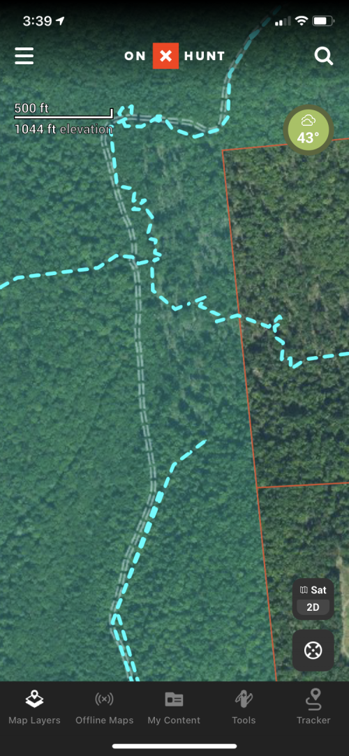
I have seen a few instances where property lines are off a bit. Below is one example. You can see the property line in the photo due to timbering verses the red line. For the record all the properties in the photo have been surveyed several times by different parties in my lifetime and the lines on OnX are not correct. This is a data problem not an OnX problem.BBA8635F-AE21-4AEB-86BE-7C090C2FD23C.png
 
  • Motorized Vehicle Use is restricted to federal, state, and dedicated county roads or other roads regularly maintained by the county, or to other roads which have been designated open by DNRC.

It does get confusing, and people are repeatedly breaking the law on DNRC roads. A study on centralizing road maps and/or actually doing some travel planning on state trust lands would go a lot farther to easing the concerns and confusion.
 

Latest posts

Forum statistics

Threads
113,671
Messages
2,029,191
Members
36,279
Latest member
TURKEY NUT
Back
Top