Use Promo Code Randy for 20% off OutdoorClass

goHUNT Mobile Maps comments sought in this thread

5th... as part of number two above, if GoHunt can't do number two, what if they were to create the opposite; a 'Road-Full' layer instead of a roadless layer... this could be better than Onx's purple roadless layer..

think about it, if you did the opposite by filling in all the areas close to the roads, you end up with the areas distant from roads that aren't colored in. In these areas, for our benefit, we can now actually see the terrain and everything else we want to look at without having to switch the purple colors off.
This would be my preference, choose shade .5 1 mile or 2miles from a road
 
3) you need a radio to do that, your gps doesn't transmit. Or you need to have cell service/internet.

4) no
Makes sense, I read the fine print on Basemap and they too said you need cell service. IMHO, its not that great of a feature if you still need cell service. With cell service, I can just send my 'pin' to my buddy.

With the shading at .5, 1, and 2 miles from road, consider using modified topo lines that sets them apart from the elevation topo lines or use color shading that represents the distance.

This would be tricky since most roads and trails parallel topo lines. On that note, it would have to be a color representation; I can't imagine lines for both road distance and topo being effective simultaneously.

May I also suggest that whatever representation is chosen for the 'road-full' layer, that the color or line pattern is a visible change from road to foot trail.
 
I have the Android version, it is difficult to click on the layer feature to add one feature without turning on or off all the other sublayers.

I am loving the species distribution in the app, it's great not going on the cpw site to view that data.
 
I’m not sure what it is that’s causing it but when working with the app offline out of cell range which is 75% of my hunting/scouting area, the app shuts off a lot it’s happened now on three separate scouting trips where I start a track and the app shuts off lose the track and have to restart my track half way through? Is there a trick I’m not doing that will help the app stay on?
 
Use the offline mode. With all these mapping platforms, if you are using it via a cell connection, you are going to have that problem. Download the map to your phone, put your phone in airplane mode, then operate from there. You do not need a cell connection to have your phone GPS working.

Hope that helps.
Sorry I guess I wasn’t clear, I am working offline with downloaded maps on airplane mode. It just seems when I am doing that it boots me out every hour or so and I have to reopen the app. Thanks for the comment though. I am unsure why it does it. I have not tried it for longer than 4-5hrs offline. I keep my phone updated and always check the app for updates so I know I’m getting the cleanest operation.
 
This would be an update for the desktop version; within GoHunt Maps, the sidebar set-up involves several steps each time you open a state, select a layer, select a sublayer, adjust transparency, etc.

May I suggest incorporating keyboard shortcuts once the customizations are set for each layer? Once the customizations are made for each layer, allow the user to hit Ctrl+(state letter)+(layer letter).

For example, each state would be assigned a single letter (WY and WA could be Y, and W, AZ gets A). Each layer gets a letter, Burn- B, Grazing- G, Terrain- T, Distribution- D. Then, the shortcut just turns the layer off or on (while using the user's customizations). To turn on/off the burn layer for Wyoming, select Ctrl Y B.

By the way, I find it very helpful to have access to adjacent states' data included in my subscription. This enhances the quality of evaluating borders during e-scouting since it allows me to see quickly see burns, roads, species distribution, etc. that may be isolated to the adjacent state, but stop right up to the border. I only had Onx for one state last year and I had a lot of burning questions while evaluating border units.
 
Sorry I guess I wasn’t clear, I am working offline with downloaded maps on airplane mode. It just seems when I am doing that it boots me out every hour or so and I have to reopen the app. Thanks for the comment though. I am unsure why it does it. I have not tried it for longer than 4-5hrs offline. I keep my phone updated and always check the app for updates so I know I’m getting the cleanest operation.
Update I had my first full scouting trip with no interruptions on Sunday morning. Did a track to my glassing location then was able to stop/ pause and resume on my large hiking loop checking out some areas. No hiccups maybe latest update helped as I did have an update when I checked for it before heading out. In total I was active offline without interruption for about 5.5 hrs. Keep up the good work GoHunt!
 
Full disclosure: I'm an OnX subscriber and haven't used GoHunt (yet).

That said, some features that would be super slick from either platform would be a way to visualize the glassable area from a spot on the map. Imagine dropping a waypoint on a ridge top and being able to see a polygon of everything that is within eye sight from that point. Maybe even have an ability to shrink/grow the radius that you are interested in (e.g. 1mi, 2mi, etc.). I currently use the 3D ground-level view to choose glassing spots, but seeing a polygon in a map view (2D) would be awesome.

Another cool add for a super-geek like me would be a sunlight/shade simulator. I'm envisioning a slider where you could choose the time of day (and maybe even time of year) to visualize what parts of the map are shaded and which are in the sunlight. Again, this is something that can be approximated in other ways, but would be an extra way to choose/fine tune your glassing and hunting spots. Heck, this could be a great tool for shed hunting too! If you wanted to get real fancy, you could even make maps of "hours of direct sunlight" or "hours shaded".
So gohunt doesn’t have a polygon but when you use the measuring tool you can make the start of your measurement at one point as you pull the cursor across the line is bright for everything visible and if it is say behind a ridge or small rise in elevation it will decrease the brightness of the line. I do like the polygon idea though.
 
So gohunt doesn’t have a polygon but when you use the measuring tool you can make the start of your measurement at one point as you pull the cursor across the line is bright for everything visible and if it is say behind a ridge or small rise in elevation it will decrease the brightness of the line. I do like the polygon idea though.
My bad I’m wrong that’s only available in the 3D desktop version not on the app at least I can’t find it was gonna do a couple screen shots of what it looked is like.
 
Full disclosure: I'm an OnX subscriber and haven't used GoHunt (yet).

That said, some features that would be super slick from either platform would be a way to visualize the glassable area from a spot on the map. Imagine dropping a waypoint on a ridge top and being able to see a polygon of everything that is within eye sight from that point. Maybe even have an ability to shrink/grow the radius that you are interested in (e.g. 1mi, 2mi, etc.). I currently use the 3D ground-level view to choose glassing spots, but seeing a polygon in a map view (2D) would be awesome.

Another cool add for a super-geek like me would be a sunlight/shade simulator. I'm envisioning a slider where you could choose the time of day (and maybe even time of year) to visualize what parts of the map are shaded and which are in the sunlight. Again, this is something that can be approximated in other ways, but would be an extra way to choose/fine tune your glassing and hunting spots. Heck, this could be a great tool for shed hunting too! If you wanted to get real fancy, you could even make maps of "hours of direct sunlight" or "hours shaded".
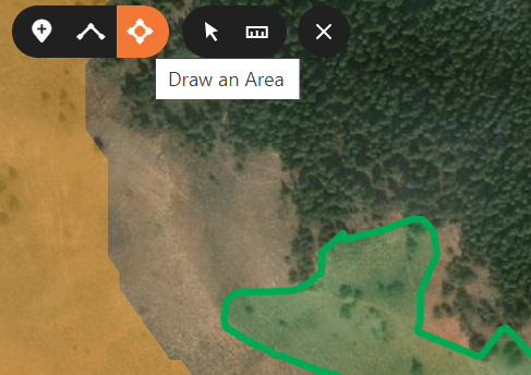
Gohunt has the polygon tool, but it's called "Draw an Area"; you can click for each point of a polygon or just hold the right mouse button down for a smooth and wonky shape like the green shape below:

1626977732192.png

Once drawn, it tells you the area and square miles. In the example above, I circled game traffic.

The sun-shaded issue can be addressed by knowing your east from west. As I spin the 3D map, I loose coordination and click the compass button that returns it to North as up.

The line tool mentioned by BT above is also valuable since it also shows you the distance if you climb down in valleys and over ridges to a certain point. That same line simultaneously displays the 'crow-fly distance' or the distance your bullet will travel.
 
So gohunt doesn’t have a polygon but when you use the measuring tool you can make the start of your measurement at one point as you pull the cursor across the line is bright for everything visible and if it is say behind a ridge or small rise in elevation it will decrease the brightness of the line. I do like the polygon idea though.
Thanks for the idea. The brightness on the measure distance tool sounds useful! An auto-generated polygon from a single waypoint would just be a step up from this concept.
 
Gohunt has the polygon tool, but it's called "Draw an Area"; you can click for each point of a polygon or just hold the right mouse button down for a smooth and wonky shape like the green shape below:

View attachment 189111

Once drawn, it tells you the area and square miles. In the example above, I circled game traffic.

The sun-shaded issue can be addressed by knowing your east from west. As I spin the 3D map, I loose coordination and click the compass button that returns it to North as up.

The line tool mentioned by BT above is also valuable since it also shows you the distance if you climb down in valleys and over ridges to a certain point. That same line simultaneously displays the 'crow-fly distance' or the distance your bullet will travel.
To clarify, I'm not looking to just draw or measure polygons. My idea was an auto-generated polygon of the visible (line of sight) area from a specific point. Basically, drop a pin on your prospective glassing knob and a polygon would be generated highlighting what areas can (or can't) be seen from that point.

On the sun-shade topic, I agree. Knowing that the sun rises in the east and sets in the west can be used to guess at what areas will have sunlight and when. My point was that in steep, and broken terrain it can be difficult to pinpoint when the sun will crest a ridge and light up a hillside. Also, during the late mornings/early afternoons, it would be useful to predict what areas receive shade from neighboring topographic highs and could provide cover during hot days.

I realize that these are small, nit picky things that would be cool to check out (and better suited for the desktop app). These platforms have so many great features already and have checked off all of the essentials.
 
  • Like
Reactions: JAG
Leupold BX-4 Rangefinding Binoculars

Latest posts

Forum statistics

Threads
114,009
Messages
2,041,030
Members
36,429
Latest member
Dusky
Back
Top