Ollin Magnetic Digiscoping System

Crazy Mountain Trail Proposal Scoping!

Considering myself a principled person, I agree with both tjones and Nameless to a great extent. However, I am also a "git-er-done" kind of guy who often is forced to allow pragmatism to succeed over take-it-to-the-mat, do or die whatever the costs and time expenses. I guess that's why I drive a good, but used truck.
 
Kat, I have consistently maintained in this thread that we could win a lawsuit, even if I don't know for sure (and there is never a guarantee). There is no need to make a case here for winning here - I am not denying it.

The purpose of this thread is to explore alternatives to a lawsuit. Even the lawyer who presented at your meeting, Tim Callahan, believes that in general it is best to try to negotiate. I believe at your meeting Bernie Lea, president of PLWA, said we should explore an alternative solution. He certainly said that at the working group meeting while sitting next to you, and in a follow up email where you were copied. Dale Spartas, former board member of PLWA has been public about his support for exploring an alternative solution. There were other PLWA members there...

MWF, RMEF, Mountain Mommas, myself and even Don Thomas (and others) recently penned an editorial saying
We support the Forest Service thoroughly exploring this option. The proposed reroute may very well strike a balance between the rights of property owners to control access to their land, and the right of the public to have access to national forest land that belongs to everyone.
(When it is printed I will link to it.)

That does not mean we are ruling out a lawsuit.
In fact, everyone on the access side is explicitly reserving the right to litigate until we are satisfied other option is acceptable.

I would VERY MUCH like to see another thread where you present your information. It is useful and relevant information. We all respect your research. However, and I don't want to open wounds, but what you really need to do is convince a LAWYER that you have a case, not the public.

None of us are qualified to evaluate your information. At this time you do not have the backing of any lawyer, or PLWA. I'm not saying you won't eventually get that, but if you want to benefit the public with information, have a person very familiar with the subtleties of the law and litigation make the case here.

Again, by all means present your info in another thread and discuss it, but please leave this thread to exploring the alternative. That is the preferred solution by all groups that were present at the meeting except FOCM. Exploring the alternatives does nothing to inhibit your ability to litigate. I believe nothing is stopping you from filing one right now.
 
Last edited:
If someone wants to hunt, hike, or ride a horse through this country, do it. This new trail is not going to provide any additional access. None. Not a single square foot. That's not "technically correct", it's "correct." If someone wants to ride a mountain bike, go to the Bangtails, Bridgers, Tobacco Roots, Gallatins, Three Forks, etc., etc., etc. If someone wants to ride a dirt bike, go to the Bangtails, Bridgers, Tobacco Roots, Gallatins, Three Forks, etc., etc., etc. If I were an avid mountain or dirt biker, I might be pissed that I lost access to this trail (and others). However, I'm not, so I don't feel the need to waste my time or my taxes paying for someone else's recreational opportunities. However, I encourage THEM to fight for it. Anything other than getting the old trail or abandoning the idea of building a new trail, will only diminish the hunting and quality of life for the wildlife in that area. Moreover, the fact that we're wasting time on this is preventing the FS from doing something productive elsewhere.

On a related note, since when is $150K not a lot of money? If spent wisely, a lot can be done with $150K.

Finally, Rob, I don't think you're qualified to speak to the qualifications of the entire HT community.
 
Or take it to the next level, what is best for the country? Punching that trail through the heart of undisturbed big game habitat will do more harm then good. Trails attract people, hikers, bikers, etc,,The country can be accessed without a trail, just takes more work. If opening the area up to the masses is the goal then the new trail is the way to go. If preserving wild spaces and the things that live there factors into the discussion then stay with the existing trail. If I hunted there I would fight the new trail to the end.
This and Straight Arrow's litmus test are extremely relevant. However, bear in mind the litigation option could wind up being worse for wildlife as the lowlands are more critical winter habitat and the elk will be disturbed by winter traffic. Motorized has more impacts than foot traffic. A biologist at TU told me the use in the lower elevations is a bigger issue for cutthroat than a trail designed to modern standards.

Remember, the options aren't Trail or Litigation. Try to think of other alternatives to the trail. Maybe re-open the Elk Creek-Trespass trails to motorized, like they used to be. That would give everyone a Porcupine to Ibex option. I am certainly advocating that the trail be moved as far west as possible, even encroaching on his land if necessary. Another idea is no trail, but part of Section 35 is bought by the Forest Service. This is about exploring alternative solutions.

I sure as hell wish there was a way to decouple Trail 195 and Trail 267. He has agreed to grant an easement across his land, but the condition is to move 267 somewhere else. Correct me if I'm wrong, but it isn't unusual for the landowner to get compensated for granting an easement so maybe instead of spending $200,000 on a trail or a lawsuit, we can negotiate a lease somewhere on his property that would please everyone.

So give me ideas. I will forward them on and see if they are even an avenue worth exploring.
 
Last edited:
If someone wants to hunt, hike, or ride a horse through this country, do it. This new trail is not going to provide any additional access. None. Not a single square foot. That's not "technically correct", it's "correct."
A minor observation, the corners of sections 35 and 25 prevent a clean pass from Sections 26 to 36. A clean path though there and a clean path through trail 195 is there for the asking if you aren't concerned about keeping trail 267. At least advocate for that to help access.

Finally, Rob, I don't think you're qualified to speak to the qualifications of the entire HT community.
If you want to explain what you are talking about, PM or email me. Otherwise, keep the personal insults to yourself. I am trying to be helpful.
 
Last edited:
A biologist at TU told me the use in the lower elevations is a bigger issue for cutthroat than a trail designed to modern standards.

Quit cherry-picking. In one of your rants about Kat, didn't you mention that this creek was dry and that trout were essentially a none issue (I'm summarizing based on memory)?

I used to be on your side, but this whole Kat fight has me really confused on everyone's motives...
 
Rob, do you know anything about TJones? What does he do for a living? What does his wife do for a living? What about his son? What did he do for a living 20 years ago? What did he go to school for? Does he volunteer? If so, doing what? What about Straight Arrow? What about MTTW? What 300stw? What about me?

My point is, it's awfully bold for you speak to the qualifications and experiences of an entire forum with regards to what we can and can't understand.
 
Mike - I don't know Tjones personally, but I know of his advocacy and respect his opinion. I personally know Straight Arrow. I have never met MTTW and know nothing about him. I have exchanged numerous emails with 300stw. I'm 99% sure you are Mike Duncan, a fish biologist and (I think) an adjunct at the Univeristy and live in Belgrade. You once offered to meet me for a beer and I would gladly take you up on that. The issue with Kat is extremely complex and frustrating and I don't want to open any wounds, but I will gladly give you me phone number and we can talk about this. I sure wish Kat and I could patch things up. The olive branch is out there.

But I will ask you again to take the personal stuff elsewhere, even if you start a new thread. I am trying to understand everyone's concerns.
 
Quit cherry-picking. In one of your rants about Kat, didn't you mention that this creek was dry and that trout were essentially a none issue (I'm summarizing based on memory)?

I used to be on your side, but this whole Kat fight has me really confused on everyone's motives...
I am sorry my stuff sounds like a rant. It is difficult to hide my frustration. Elk Creek is dry on Google Earth. Pat Byorth told me he was more concerned about down low. Call him, I'm sure you know him. Another staffer said something similar but it was an unfamiliar name and I forgot it. Those are facts and I don't know how they reconcile.
 
When frustrations like mdunc8 boil over it is a sign I'm talking too much. I've been replying to encourage a back and forth discussion of the issues, not to disagree. Unfortunately, I'm sometimes not very good at communicating.

I encourage you to reach out beyond this page. Absolutely feel free to contact the people below.

My name is Rob Gregoire and I'm in the Bozeman phone book. Leave a message and I'll call you back.
PM Kat. She will talk on the phone with you. Trust me ;)
Brad Wilson, Friends of the Crazy Mountains, lives in Wilsall. (His number is available online – he ran for office once)

The following groups have expressed support publicly for exploring a negotiated settlement:
Montana Wildlife Federation (Nick Gevock)
Rocky Mountain Elk Foundation (Eric Hull)
Park County Environmental Council (Erica Lighthiser)
Livingston Bike Club (Not sure who the contact is)
Call them and ask why!

The following individuals have expressed support publicly for exploring a negotiated settlement:
Dale Sexton (part of the working group), Timber Trails in Livingston
Don Thomas (The former DU author, and author of new article about Crazies for BHA https://www.backcountryhunters.org/crazy_business)
Feel free to contact them if you can find their number or email.

The following agencies are involved closely in the issue. It is their job to talk about this. Call them.
Custer Gallatin National Forest, Chad Benson, Bozeman, 587-6701
MT DNRC Public Access Specialist, Ryan Weiss, 444-5576

The following groups are very closely monitoring the situation but have not formed an opinion until they are sure all the facts are known. Call them and get their point of view!
Public Land/Water Access Association
Backcountry Hunters and Anglers

MFWP Commissioner Dan Vermillion is familiar with what is going on. I don't know if MFWP is directly involved.

I know very little of these groups, but they signed onto a recent (not yet published) editorial in support of negotiating:
Crazy Mountain Working Group, Crazy Mountain Stock Growers Association, Montana Stock Growers Association, Montana Department of Natural Resources and Conservation, Western Landowners Alliance, Montana Mountain Mamas

Friends of the Crazy Mountains (esp Kat and Brad) and Harold Johns oppose (not sure if Harold was speaking for Skyline sportsmen or not) (http://mtstandard.com/opinion/colum...l&utm_source=facebook&utm_campaign=user-share

I know other people in opposition (and support), but I haven’t seen their name in print so I won’t publicly disclose them without their permission. If I left someone out it was unintentional. Kat can certainly add other names.

Heck, call Spencer at Daines’ office or Eric Nylund at Tester’s. They are following the issue. I talked with Spencer Tuesday.

Feel free to contact these people and groups and get their perspective – they’ve gone public and can expect a phone call from people wanting to know more, especially the Sportsman's Groups. I'm not afraid of any facts or opinions. The only thing I'm afraid of is that people mistakenly believe exploring this option will prevent the public from litigating if they don't like the result of the negotiation. To my knowledge, that is not true.

The only other thing I ask is for you guys to keep discussing it. I'm open to ideas. The stumbling block is how to mitigate the requirement that Trail 267 be moved from its current location.

PS: I'll assert this is mdunc8, but not 100% sure. ;)
 
Last edited:
Rob... Are you still having legal expenses going forward with this? If so, could you post up your gofundme page again? I'd like to contribute.
 
Last edited:
Very informative conversation, I really appreciate the exchange of facts rather than making baseless hyperbolic remarks (even though there is some of that).

I'm a firm believer in private property rights but I don't support a private property owner who believes that they can block public roads. If you buy a piece of land with a public road on it then you have no right to block that road. Unfortunately it seems that all a land owner has to do is say that the road isn't public (even if it's been used for the last 100 years by the public) and that triggers the need for the court to decide the issue. Even then I don't understand why the issue is so difficult to resolve, if a judge has statements from a reasonable number of responsible authorities stating that a road is known to be a public road then I'd think that it's pretty obvious that the road is public.

On the other hand, if the road has always been gated and the owner simply allowed people to cross by keeping his gate unlocked then I'd say that the road wasn't ever public and it's up to the owner to decide how it's to be used.

In regards to alternate routes, I'd rather negotiate an agreement between the stake holders than go to court. I don't see any benefit to just forcing your will on a land owner, forcing someone to conform to a mob's opinion isn't the point of the argument. Even if it seems obvious that you could win litigation I don't see where it's worth the time and money if there is a reasonable alternative. I do see the point about an alternate route disturbing the elk and driving them on to the private land but I'd like to see more proof of that being a real possibility, just taking a layperson's word that it will happen isn't really enough reason to not use the alternate route. If I had a Forest Service report that said that there is a strong possibility that this will happen then I'd be a lot less comfortable with the new route. Personally I don't see where the elk would prefer open, flatter private land to rougher, forested public land. I understand that they will move to safer places when the hunting pressure increases but elk don't make logical decisions based on their knowledge of who owns the land, they make decisions based on their instinct and experience and elk always move toward rough, forested country for security, if the private land is more secure then that's where they will go, but from what I see on the maps it looks like there is a better chance that most of the elk will move toward the public land.

Regardless, if the wording of the negotiated agreement for the new route didn't prevent it then I don't see why you couldn't pursue litigation later to prove that the road is a public road. If the litigation were successful then simply close the new route and push the traffic back to the public road.
 
Last edited:
Working as a land surveyor on a lot of linear projects, I have done quite a bit of a deed and chain of title research. The document Kat posted in post number 50, in my opinion, is too vague to know at face value what trail is being talked about. That is not to say that additional information, perhaps a legal description, could not be found with additional digging. I have not had time to look into what she posted about the railroad grant, perhaps it is in there.
But the language in post 50 underlined in red by itself will not get you there. It is interesting language. Often you will see a very vague catchall statement about entitlements, encumbrances, easements, and other rights as a way for the grantor of a warranty deed to say in a way ‘just in case these things i don’t know about exist, their rights are conveyed with the lroperty’ . Or you will see specific encumbrances, in this case a trail easement mentioned, but they will usually reference another document that you can pull and it will give you the specifics on said encumbrance.

The wording in red is kind of a hybrid of the two and is rather peculiar in my opinion.


Rob, have you considered talking to someone like the regional chief cadastral surveyor? He can’t and won’t offer you legal advice but should be a subject matter expert and could offer you his opinion and understanding of some of this wording.

I understand you’re an engineer. Perhaps you have an experienced PLS at your office?
Surveyors can only locate the physical location of something, and offer an opinion, while legal determinations obviously are left to the courts, but they may be a source of FREE knowledge or advice (as opposed to an attorney they will talk to you for 30 minutes without a retainer.)
 
I went to the EQC meeting involving this subject earlier, that had been requested by John Brenden, Chuck Rein's brother-in-law. Rein was also there and made a public comment.

Terry Anderson, from PERC, was there on video conference. He stated, concerning the Crazy Mountains, that he counted 13 trailheads into the Crazies, asking again the question, "How much is enough". When I made my public comment, I adressed this, stating that while the Forest Service had a number of trailheads on the map, that a number of those trailheads, with their signage and visitor sign in logs had been removed by private landowners and replaced with their own private property signs, stating people needed to ask landowner permission or sign in.


I believe at your meeting Bernie Lea, president of PLWA, said we should explore an alternative solution. He certainly said that at the working group meeting while sitting next to you, and in a follow up email where you were copied. Dale Spartas, former board member of PLWA has been public about his support for exploring an alternative solution. There were other PLWA members there...

MWF, RMEF, Mountain Mommas, myself and even Don Thomas (and others) recently penned an editorial saying (When it is printed I will link to it.)
...but what you really need to do is convince a LAWYER that you have a case, not the public.

...At this time you do not have the backing of any lawyer, or PLWA. ... I believe nothing is stopping you from filing one right now.


Rob, Bernard Lea is just one of the PLWA Board of Directors. While Bernard has been vocal about his opinion on the west side of the Crazies and this Porcupine Lowline Trail, there are other PLWA board members who have opposed this position, Tony Schoonen, for one (who sent written copies of his position to the meeting, including a statement about filing a lawsuit against the landowners that are illegally blocking the existing trails). To my knowledge, as of a half hour ago, PLWA has not legally met as a board, taken a vote on this subject. Until such time, Bernard's opinion is just that, Bernard's opinion.

Aside from PLWA Director Lou Goosey, none of them have been on this trail. Dale Spartas, who did not answer that he has been on this trail, is no longer a director, he resigned after one year of a 3 year term. He is simply a member at this point. While Dale owns some property with a rental cabin, just a bit southeast of the southeastern corner of the Crazies, on the Yellowstone River, and is welcome to any opinion he may decide upon, he has not brought any facts to the table. I was surprised that he introduced himself at the meeting as a previous PLWA board member, instead of his cabin ownership, fishing guide and photography business that also photographs private landowners lands and hunts. I would think the business interests would be more relevant than a general PLWA membership, as to why he was invited to the "private" meeting.

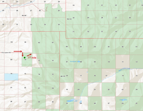
When Dale asked at the meeting, how far you would have to go to get onto public land to hunt, I zoomed into the map and showed the Porcupine Lowline Cabin (parking area) and trailhead (4N 10E Sec. 10), pointing out the public land to public land corner overlap, leading into a ton of contiguous public lands, he was unaware of it. Once you park, it is approx. .77 mile from the parking area to the overlap.

hike through overlap.png

But while you bring up the Jan. 31st meeting, PLWA Vice-President John Gibson, also retired Forest Service, was also there and John Gibson did not endorse the proposal, in fact, he passionately spoke about the landowners, of which Zimmerman is one, that tried to get Yellowstone DIstrict Ranger Alex Sienkiewicz fired. He spoke about the politics that were going after public access. He spoke about the importance of historical prescriptive easements and litigation.

While Lighthiser (Montana Mountain Mamas as well) supports this and may work for PCEC, having heard that Park County Environmental Council board did not endorse this Porcupine Trail Relocation, I called the President, Nelson King just a bit ago. He stated that they have not made a board decision to endorse this trail relocation. King stated they are looking at the process, information and other alternatives. King was at our public meeting the other night.

I think it goes without saying, but you are not knowledgeable of my discussions with any attorneys, nor all the PLWA Board members positions on this relocation proposal.

I do not make my decisions based on the majority opinion, nor am I intimidated if the majority holds a different opinion. I look into science, law and facts, just as I have for years, like FS 166B Road, Durfee Hills trespass, Middlefork of Sixteen Mile, Gianforte's FWP fishing access site lawsuit, Troy Downing FWP citations, Sienkiewicz' removal, etc.

I have publicly advocated for trail/road relocation proposals, but based on all I am looking at from a proper FS NEPA process, costs, engineering feasibility, legal easements, historical documents, maps and prescriptive easement information, fish & wildlife, landowner history, railroad deed easements, losing motorized access, fuel tax access, etc., this is not one I can advocate for, but that is just my opinion in this "public scoping" proposal.
 
Yesterday, I had to leave for the Skyline Banquet in Butte (stocked up on smoked kielbasa while there), didn't take my laptop with me, so I had to wait until I got back today to post this.

Montana Wildlife Federation submitted their public comment, which came up at the FOIA Reading Room.

MWF is involved in finding opportunities that improve public access to public lands. The issue in the Crazy Mountains on the Custer Gallatin National Forest has been at the forefront of public access disputes for many years. The Crazy Mountains have very few access points to get people to their public lands, and disputes over trails have simmered for years. With that in mind, the project to build a new trail on the west side of the Crazies holds promise. MWF supports securing permanent legal public easements on the involved private land first and foremost. We believe that legal public access on legal public roads and trails is the first priority, but if the Forest Service is going to go ahead with considering this proposal, we offer the follow questions that need to be answered:

1.What would be the effect of the new trail on big game distribution, for example, would it have the potential to push elk and deer off of National Forest lands?
2.If there are stream crossings, what would be the potential for sedimentation, and what potential mitigation would work?
3.The legal easements on private land for this new trail are critical to secure before any rehabilitation and relinquishment of the existing disputed trails, #267 and #195.
4.The wildlife impact analysis could also extend beyond big game species. The analysis should look at how the trail could impact smaller mammals, game birds, songbirds and other species found in the area.

We have these concerns and would like to see the best science applied to answer these important issues for our public lands. At the same time, MWF is eager to see improved public access in the Crazy Mountains. We recognize the difficulty of achieving that, given the historic checkerboarded nature of the land ownership there and a history of contention over the trail system. We are willing to work with the Zimmermans and the Forest Service to reach a goal that gets the public to their lands, while maintaining a level of habitat security.

Please enter these comments as part of the official record. Thank you for the opportunity to comment on this important proposal.
 
I think that is an excellent comment by MWF, and a model to follow:
1) Express support for collaborating with the Zimmermans
2) Share any concerns so they can be addressed

BHA also submitted comments (as well and Kat and Brad Wilson). You can download them by going to https://www.fs.usda.gov/project/?project=53388 and clicking on the "Public Comment/Objection Reading Room" link on the upper right of the page. The files open with adobe acrobat even though they don't have a pdf extension.

I should have my comments done soon and I will post them.
 
My near-final draft of my comments:
I have been involved in the Crazy Mountain access issues for some time. There are five contested trails that the landowner claims the public does not have the right to use in spite of evidence of historical use: Trails 195, 267, 122, 136, and 43.

I strongly support working with the Zimmerman’s to achieve an acceptable solution to the dispute on trails 195 and 267. A successful negotiation would:
1) Solve the access issues on two of the five trails: 195 and 267.
2) Build trust amongst the Crazy Mountain Working Group, which will encourage more collaboration on the remaining three disputed trails.
3) Secure a passageway through or around section 35.

While I support the process, I am very reluctant to support the proposed location of the new trail, which roughly follows the 7900’ contour around the drainage at the common border of sections 23 and 26. That mountainside is very steep, and appears to be very rocky so it is not a good place for a trail. The bigger problem, however, is this basin appears to provide heavy forest cover. A trail through this area would affect wildlife security. In addition, the easy access would reduce the quality of hunting in this section. There are similar issues in the southern half of section 26.

A route that hugs the western boundary of sections 23 and 26 is much less intrusive and shorter, and the terrain appears more suitable for trail building. I have included Google Earth screenshots of the area with 1) trails 195 and 267 in their existing locations (Blue), 2) the trail as proposed by USFS (red), and 3) a possible route (white) to reduce the issues with the USFS proposed location.

As drawn, my proposed route leaves section 23 and 26 and goes onto Zimmerman’s land. This avoids unnecessary elevation gains and switchbacks, but may prove to be unnecessary. The main issue of concern for me is to avoid deep incursions into the drainages of sections 23 and 26.

Truthfully, I would prefer no trail at all through sections 23 and 26. If an easement to the public land portion of Trail 195 is secured, these sections can be accessed by hiking cross country from Trail 195. The Porcupine/Ibex connection could be made using the Elk Creek/Trespass route. If a corridor or even a small corner of section 35 was given to the Forest service the corner crossing issue at sections 25 and 35 would be eliminated and the entire corridor could be accessed from either end.

Understandably, if trail 267 is moved or eliminated the public needs to be compensated in some fashion, but maybe there is an alternative to putting a new trail through sections 23 and 26.

Finally, for the record, after talking with many people it is clear many of them have been misinformed about this proposal, and to some extent this is to be expected because the trail location is not finalized. I think the Forest needs to nail down the location of the trail and present it to the public for further comment. In addition, other alternatives that address the concerns of the affected parties should be explored and presented at the same time.
 

Attachments

  • Screenshot.jpg
    Screenshot.jpg
    151 KB · Views: 522
Back
Top