Crazy Mountain Trail Proposal Scoping!

Fight for the old trail, or leave it alone.
It's in the "fight" that creates the conflict and the cost. Priorities: Is access to public land the goal? ... or is setting an example by punishing a landowner the goal?

A general frustration over public land access versus private landowner property rights is the contentious process which creates larger divisiveness and greater costs for all parties. Whenever a compromise (such as this seems to be) can be reached, I think it perpetuates a healthy precedent. For the sake of saving time and money, the effort to work out the devilish details is effort well expended, IMO.
 
maybe save the time, effort and money that it would take to get the new trail, and use the resources in a better spot, let the landowner close the trail,

I am assuming there is a better area on the east side to put forth the effort, from the research I have done the east side needs much more help,,,,
 
Then go over to the east side and spend the limited time and resources to open country that we don’t already have access to.
I am confused by your comments. Do you know that the trails in the proposal are currently blocked off? We have no access to them now. What are you talking about? And if we do nothing the landowner completely wins.
 
maybe save the time, effort and money that it would take to get the new trail, and use the resources in a better spot, let the landowner close the trail,

I am assuming there is a better area on the east side to put forth the effort, from the research I have done the east side needs much more help,,,,

I'm not arguing, but I am also confused by your comments so I am trying to understand. The proposal would require relatively small time, money and effort from the public. Litigating would require significant time, money and effort from the public. The "easy" way out is to accept the proposal.

Letting the landowner close the trail would be a complete cave in that I just can't stomach. While I have questions about the need to keep trail 267, and the wisdom of routing it through roadless, the landowner will grant a permanent easement on trail 195 up to Cottonwood Lake, and that is worth a lot.

On the east side, I do not know how strong the cases are to open up Swamp Lake and Sweetgrass. I know they have been permissive use for a long time, which would normally extinguish the claim to an easement, but the FS has never acknowledged permission required so that may offset it. "My" trail, 115, could possibly be opened by litigating, but it only opens access to a couple sections of land and we'd still have a lot privatized because of checkerboard. Negotiating a solution on trail 115 could open up a lot of previously privatized checkerboard and be a more significant win than the west side.
 
We don’t need a new trail, or any trail for that matter, to access any of the public land. Get out of your truck with a GPS, map, or compass and start hiking.
 
We don’t need a new trail, or any trail for that matter, to access any of the public land. Get out of your truck with a GPS, map, or compass and start hiking.
Thanks for clarifying. I'll grant that you are technically correct. However, if we don't open up trail 195 the access to the west Crazies (S14, 23, and 26) will be very difficult for the public, but the private landowner will be able to drive his clients right up to the property boundary. Essentially we would be rewarding him twice for closing the trail: not only would he get the people off his property but he would, for practical purposes, be privatizing the USFS land bordering his property. I can't stomach that.

Let me throw this out: What about him granting an easement across his land to Trail 195, and just abandoning trail 267? He'd obviously go for that, and I think most here might rather keep the area south of trail 195 remote, but I have a feeling most of the public won't want to abandon the connection.

rg
 
Last edited:
so,
section 11 has an easement if I read correct earlier, that allows trail 267 from the south into northern boundary of section 2,
section 25 has an easement for trail 195,if I read right earlier, already a trail in section 23-24,
so get the easments for sec 15 to get on these trails, use existing trail in sec 15,
do away with the balance of 267 thru the private,

public would give up 4 miles of trail on private, that you have said doesn't benefit us, and public is unlikely to ever get easement on the trail,
so with this scenario, theres not a piece of public land you couldn't hike horseback into to hunt, not spending 150,000 on trail building, what would be the negatives with this scenario?


whats the trail easements for campfire lake and moose lake, if theres issues solve them at same time maybe?
 
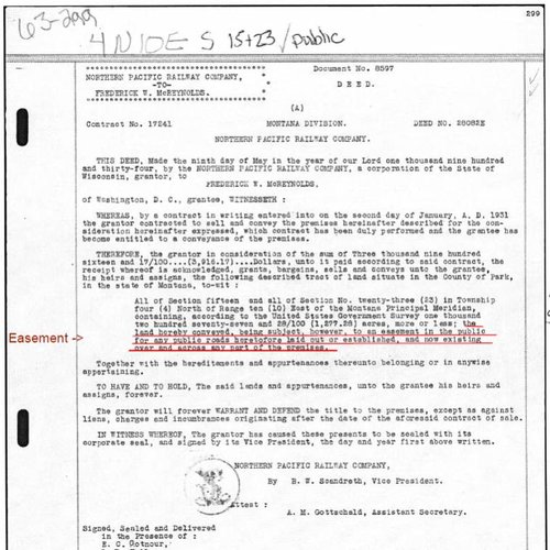
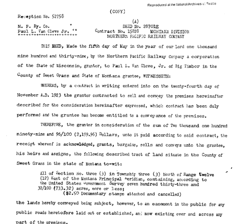
I was asked to please post this here. It is a Screenshot of just one of the many Railroad Grant Deeds with an easement in the public for roads and trails that I have spent hours researching, including roads leading into the Forest Service.

This one is for T4N R10E Sections 15 and 23, sold to McReynolds in 1931, which #195 runs through and did so before this Deed was executed. Trail #267 was also there before this Deed. I also have one for Zimmerman's part section 11 and all of section 35.

Easement 15 and 23.jpg

The full pdf is on this documentation page, as well as an explanation of the others on the map, meeting video 28:24 segment.

We already have easements.

We could not capture Shaun Jones' public comment at the meeting, as the attorney went over the allotted time. Jones is a Crazy Mountain landowner, who is very familiar with the area and terrain. He just submitted his public comment at the FOIA Reading Room, stating the same thing he did when he stood before the 3D Map I had projected on the wall.

I have property within a few miles of this trail. I am not in agreement with this relocation for the following reasons.
1. It will now be considered a non-motorized trail. We have very few left in that area. You have taken away Trespass, Cottonwood, sheep creek to Rock creek, how much more are you going to take from us?
2. The new trail location is unrealistic and way to steep (especially for motorized). I can tell you haven't spent much time there. We already have high altitude trails. Keep our existing low altitude trail with motorized.
3. You are asking us to comment on a trail that has only been looked at on paper and computer-need more time.
4. The proposed trail would be put right through prime elk habitat. The traffic would force the heards that stay on the West slope of Trespass down onto private where the existing trail is now. As it is currently, because the current trail goes through private land the elk move up the mountain side and stay where the new proposed trail is located. Now we have hunting possibilities on the West slope but if you re-route the trail through the middle of the West slope all the elk will be down on private with less opportunity for hunting. I have spent 40 years in this exact location we are discussing and it is way to steep and costly to put a trail through this proposed site.

We have a trail existing and we do not need to spend this kind of money to relocate it. Let's use the money to improve existing trails (specifically #267). We need more time to look at everything related to this. This is just one more way to close off motorized travel. These plans ruin our way of life. Please quit changing our way of life!

Thanks for listening
Shaun Jones
 
Last edited:
if the easments are this "cut and dried" so to speak, then what could possibly be the hold up to open the trail or public use on this trail,,,,,,,, rob have you seen all this, what does it mean to you?
 
I don’t get it. Everything I read screams win yet it seems the majority wants to cave to the landowner.

If it takes time who cares? You don’t need a trail to hunt elk from.
 
A sincere thanks Kat.
if the easments are this "cut and dried" so to speak, then what could possibly be the hold up to open the trail or public use on this trail,,,,,,,, rob have you seen all this, what does it mean to you?
I haven't seen it, although I do not dispute that case could probably be won, it would just take a lot of time and money and it would negatively affect negotiations on the other side. If a recorded easement exists for the desired use I believe it means Zimmerman can go pound sand. He has absolutely no case. We don't even have to go to court. We are done and this proposal is moot. Somehow I don't think that is the case but I will follow up unless Kat tells us why we would even have to go to court given this deed exists.

Regarding Shaun's comments on steepness, the trail location isn't settled, and I don't think the proposed location is going to pass muster. However, the grade is about 7.5% for most reasonable tracts (about 1200' in 3 miles), including the one proposed. That isn't very steep.

For comparison, the grade up Elk Creek on FS property is 12% and this was previously open to motorbikes. Also, the "easy way" to the M gains 840' in 1.2 miles, which by my calculation is 13%. Mountain bikers told me they don't like sustained inclines greater than 10% and any reasonable route will be less than that.

However, Shaun is absolutely correct that Elk and Trespass lost their motorized use. On the other hand, I really don't think the powers-that-be are going to support continuing motorized use on 267 through private property if the landowners don't want it. That's just speculation. I should note that it is perfectly reasonable to ask for a motorized easement on the path to Elk Creek to open this area back up in the future if that is what you want.
 
so,
section 11 has an easement if I read correct earlier, that allows trail 267 from the south into northern boundary of section 2,
section 25 has an easement for trail 195,if I read right earlier, already a trail in section 23-24,
so get the easments for sec 15 to get on these trails, use existing trail in sec 15,
do away with the balance of 267 thru the private,

public would give up 4 miles of trail on private, that you have said doesn't benefit us, and public is unlikely to ever get easement on the trail,
One correction: you wrote "public is unlikely to ever get easement on the trail" I didn't say that. In fact, it is likely that we COULD prove an easement exists thanks to Kat's great research, but it would require a long and expensive court battle. That's the issue here: does litigating or re-routing serve the public's interest best, and you have to include how litigating affects the overall access situation in the Crazies. It is not a simple question, but there is no harm in looking deeper into the re-route. If it isn't going to work we can reject it.

so with this scenario, theres not a piece of public land you couldn't hike horseback into to hunt, not spending 150,000 on trail building, what would be the negatives with this scenario?
The negative is that you would be giving up something of real value: the right to use trial 267 (in its current place or re-routed) to go from Porcupine to Ibex. I don't know what that is worth, but at the very least it is a bargaining chip for something.

whats the trail easements for campfire lake and moose lake, if theres issues solve them at same time maybe?
The trail by Moose lake (section 29) has an easement on it. Campfire is on public land.
 
I have changed my thinking on the trail relocation thanks to this discussion. As others have said this is not really about access to public land. It is about easier access to public land.

Traffic in the Sheilds drainage of the Crazies has increased drastically in the last few years and I would expect that use to continue to increase with the population growth of the area within an hours drive.

This trail relocation will turn wild land in to not so wild land, and an area that was accessible but lightly used, will be heavily used. Possibly by motorized travel.

The elk hunting in the area is now available to anyone with the fortitude to take on the challenge. If the relocation takes place the hunting will presumably go the route of many other areas like it where the landowner harbors the game, and the public stands on the mountain that is almost void of game and watches him sell the bulls on the lower country hoping something will come their way.

The info that Kat has provided sure makes it look like the land owner isn't holding much of a hand.

I say go for the original trail and if it takes many years then so be it. At least we wont have spoiled wild land in favor of easy access for the masses.

It is really cool that we appreciate wild areas these days. Such talk was heresy not too long ago.

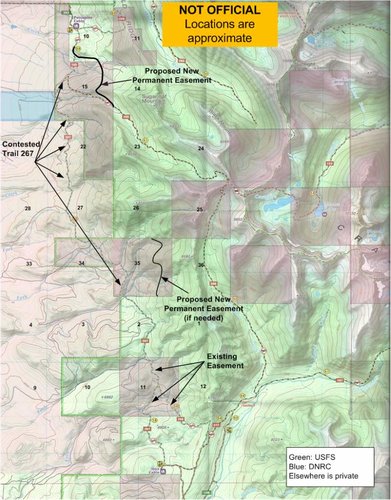
However, we already have "for free" everything I think you want. Take a look at this new map I made. The landowner says he will give us a permanent easement (black line) to Trail 195, in exchange for moving (or abandoning) trail 267. If needed, we also can get a permanent easement across the east side of section 35. For elk hunters, I don't think we need or want to go any farther. It is other people we have to consider.

Litigating to open the original trail 267 won't give us an inch more of public access. What it will give us is a path across about 6 miles across private land from the top of Section 15 to Section 2. Pessimistically phrased, the only thing litigation will do for access is to give us a 6 mile route to section 2 instead of the uncontested 3 mile route from the south.

Here's where it gets messed up. Mountain bikers, motorized crowd, possibly horseback riders (and presumably Kat and Brad) do see value in that path. I do not discount their point of view. There is value in a point-to-point ride from Porcupine to Ibex and the lowland scenery is unique. Not for me, but to some members of the public.

In addition, Trail 267 itself has bargaining value. If we are going to give up that trail, we should get SOMETHING in return. One option is re-route the trail across Sections 23, 26, and 35 to give the riders point-to-point access so the public gets a benefit.

Maybe there is a better option or we should punt and use the trail money to go buy access elsewhere. I dunno. I just want a path to get us to what we have "for free" on the map below. It is ironic that the best solution for people like me is to just accept the trail 195 easement and throw the mountain bikers et al under the bus regarding 267, but I do genuinely want a solution that benefits a wider audience.

So that is it - basically the only thing litigation will gain us over what we have for free is that 6 miles across private land. On the other hand, the cost will be substantial and it is never a guarantee that we would win.

Kat is an amazing researcher, and I am not ruling out litigation, but until I see an attorney like Geddes or equivalent promoting this it is just talk. I'm not even sure we can rally enough public support to sue for six miles of trail across private. These things are expensive. There are a lot more high value targets out there I'd rather designate my PLWA contributions for.

I truly appreciate the feedback.

Trail 195 option.jpg
 
Last edited:
I haven't seen it, although I do not dispute that case could probably be won, it would just take a lot of time and money and it would negatively affect negotiations on the other side. If a recorded easement exists for the desired use I believe it means Zimmerman can go pound sand. He has absolutely no case. We don't even have to go to court. We are done and this proposal is moot. Somehow I don't think that is the case but I will follow up unless Kat tells us why we would even have to go to court given this deed exists.

I looked closer at this and asked around. It doesn't appear to be enough. It says "public road" but does not specify which roads they are referring to. It also does not say "trail." Maps from 1925 and 1937 show roads on some of the sections mentioned (but not all). Notably there is a road on Section 15 up Elk Creek, but the last attorney that looked could not find where the roads on the maps had been recorded as public. If the public status isn't recorded we have to prove that they are public in a court of law.

Anyone can email me at [email protected] if you want pdf copies of the 1925 and 1937 maps of the Crazy Mountains.

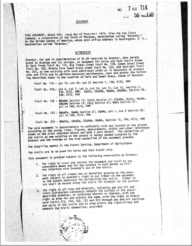
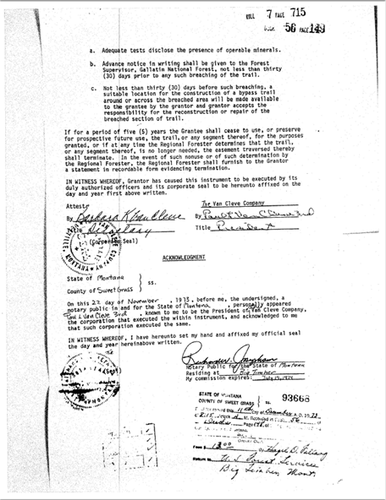
FWIW, here is an easement for multiple trails on the interior when the Van Cleves owned everything over there. You can see the relative lack of ambiguity.

Vancleave Easement 1.png

Vancleave Easement 2.png
 
In 1948, the DOJ for the Forest Service, filed a case against Van Cleve, adding Sweet Grass County, for blocking public access with a locked gate and signs, founded on 1 Railroad grant, that stated road public access, for 3N 12E Section 3. It was "enough" to base a case on, to get an injuction against the landowner and to result in the settlement.

3N12E Sec 3 RR.png

... the lands hereby conveyed being subject, however, to an easement in the public for any public roads heretofore laid out or established, and now existing over and across any part of the premises.

From the lawsuit:
That the United States has a special right, title and interest in said highway and trail and all parts thereof, including the parts thereof situated upon lands now owned by the defendants, amounting to an easement and right-of-way for said purposes by reason of the facts that said road and trail were established upon said land when it was in part public land of the United States of America and in part in the ownership of the Northern Pacific Railroad Company, and its sucessor in interest, the Northern Pacific Railway Company, which said railroad company and railway company dedicated the same as a public highway, which was appropriated by the United States and the general public prior to the issuance of any patents therefor, thereby reserving unto itself and the general public said public highway, road and trail, and by reason of the fact that the United States and its permittees and the public have for more that 50 years used said raod and trail for said purposes and the United States has, during said period from time to time, expended upon said road and trail monies appropriated by the COngress, for its construction and maintenance to the end that it might serve said purposes; and the United States in common with the public is entitled to the possession of the right-of-way for said highway and that the same is necessary for the protection, use and administration of the national forest and other property of the United States.

Not only was their case founded on the Railroad grant deed easment, but their injunction to remove the lock and signs, which the judge approved, was also founded on the RR grant deed. As soon as the lock came off, the Forest Service sent a grader in to maintain the road and install a cattle guard to protect Half Moon Campground from Van Cleves cattle that were running roughshod over the place.

Van Cleve came out with a large rock, threatening the road grader with the rock, that he would get his high powered rifle and that he woud lock the gate. This was before cell phones, so the grader left and came back another day with more guys and found the gate locked. Van Cleve came out with the high powered rifle and threatened them. The DOJ filed a quick Motion for Contempt, but did not have the testimony or photos of the locked gate, so the judge dismissed it. It happened again, but this time they got the affidavits and photos. Van Cleve could no longer excuse his court dates with haying and calving, so there was a settlement in Dec. 1953, with Van Cleve granting an easement on Big Timber Canyon Road (pg 155). That is how we got the guaranteed access we have now on Big Timber Canyon Road.

Here are close ups of the 1925-1991 maps of the Porcupine Lowline and you can clearly see Trail #267, as well as #195, which was part of the arc of North Fork of Elk Creek Road before the landowners got their lands in the 1950s, with the roads/trails already on it.

From Black's Law Dictionary - ”In all counties of this state, public highways are roads, streets, alleys, lanes, courts,places, trails, and bridges, laid out or erected as such by the public, or, if laid out anderected by others, dedicated or abandoned to the public, or made such in actions for the partition of real property.”
 
Last edited:
Seems like such a slam dunk.

I understand the perspective of negotiating and moving the trail while avoiding a messy legal battle, and also the perspective of making this landowner pay for being a d!%#head.

Part of me says win the case, and if the landowner wants the trail moved, a discussion could be had, and with the public's blessing, he could pay for it.
 
It's in the "fight" that creates the conflict and the cost. Priorities: Is access to public land the goal? ... or is setting an example by punishing a landowner the goal?
My previous post. The litmus test for me to apply is a simple question: Is access the number one priority? or is it "How can we punish the landowner?" Decide which is more important and that will guide the decision.
 
My previous post. The litmus test for me to apply is a simple question: Is access the number one priority? or is it "How can we punish the landowner?" Decide which is more important and that will guide the decision.

Or take it to the next level, what is best for the country? Punching that trail through the heart of undisturbed big game habitat will do more harm then good. Trails attract people, hikers, bikers, etc,,The country can be accessed without a trail, just takes more work. If opening the area up to the masses is the goal then the new trail is the way to go. If preserving wild spaces and the things that live there factors into the discussion then stay with the existing trail. If I hunted there I would fight the new trail to the end.
 
That's a good way to look at it SA. Punishment is only part of it I suppose though. Maybe it is naive, but I can't help but feel that fighting this will do some good in establishing an atmosphere.

This guy wrongly(yes I know not "illegally") shut down a public trail. One solution involves giving him what he wants, and yes that solution is probably a better solution in terms of access. Another solution involves taking a stand for what is ours, with an uncertain outcome and a costly process that there may not even be the stomach to fight for.

As an example of a successful tactic,if in the future a landowner doesn't like the location of a trail on his land in some other part of Montana, all he/she has to do is block it, and then negotiate it's change of course with the public. Not certainly, but a precedent exists if this trail is negotiated. Maybe this trail is a special circumstance. If that change provides better access, is that ok? Not saying I have a good answer, but am saying it doesn't sit well.
 
Last edited:
Back
Top