Checkerboard Pro-Active Solutions?

Anything that will effectively deal with corner-crossing will have to be incentive based for the landowner. LWCF being fully funded can accomplish a large chunk of this, as it relates to purchases & easements and state programs can deal with this as well. MT's Land-banking program is a good one in terms of increasing access for state trust lands.

Forcing corner-crossing legality into law isn't a winning strategy.
 
Can you explain why, I have a hard time when people use the term "likely ".
I likely mis-defined the reason as arbitrary and capricous. But, my guess is because it only affects those with grazing permits for one. Not all parcels are landlocked by grazing permit holders. Those lands by permit holders may already be in an Exchange of Use agreement. There is nothing currently in place that ties access to federal lands and grazing permits. They are separate issues/topics/concerns IMO. A grazing permittee, on BLM, is prohibited from preventing other uses of that land already. IIRC there is some precedent out of Idaho about the federal gov not being able to force access to federal lands over private. Don't think that would be changed because of a use permit...
 
There is another other thread on this board that has discussed the issue. I think I referenced it in one of the other threads,- a catalog of land locked property would be immensely helpful.

It could go a long way in taking the theoretical concept of cornercrossing to an actual game plan. Resolving a percentage of access issues could then snowball into political support for a law change/definition.

As it is now, it is a theoretical discussion about the head of a pin and whether the old English common law protects private property rights. Is it trespass, no it isn’t, yes it is, no it isn’t.
It is ambiguous at best and potentially dangerous at worst. A guy coming back to 4 flat tires is better than a heated conflict with landowner with a gun.

I think sportsman could show real leadership if they identified the actual parcels.
 
I think sportsman could show real leadership if they identified the actual parcels.


2016 election
"She has proposed using “voluntary conservation partnerships” with private landowners and state governments to open access to 2 million acres of public land now closed to hunters and anglers."

I've posted maps and threads about identifying them, @Nameless Range did a really great analysis.

Identifying parcels and bring the issue up isn't the problem. It's that billionaires have paid millions to lock you out and they want to protect their "investment".
 
@Dakotakid the other issue is that what your asking for is possible and has been done in aggregate. The problem is it gets really complicated to do detailed work.

With about 20-100 hours of work and a 20k budget I could purchase all the data to give you a really good catalog of parcels in the west. The problem is my analysis would be essentially looking a where roads or trail intersect public lands.

There are thousands of easements that this analysis would leave out because they are proscribed or only exist in a filing cabinet on a paper map in a field office in Montana. Further, how do you define access? People talk about unit 25 in WY having limited access. There is a massive piece of BLM that only has 2 points of access. So yes if you want to walk in 15 miles you can hunt it, but is that access? There is a road that goes through the whole thing, but it crosses like 400 yards of private and is shut down.

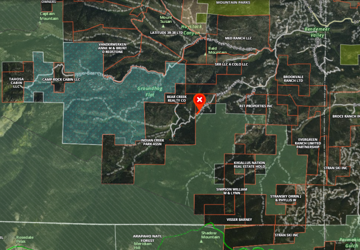
Here's one just outside of Denver. Everything below that red x is almost impossible to access.

1617111819063.png

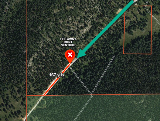
Public land crosses the road, and the slope aspect is such that you could park there, but the landowner has a gate just before (167 yards) you get there. So you can drive 1/4 a mile through his property, green arrow, but he "conveniently" has a gate just before public access. 😲 That can't be on purpose, he definitely wouldn't fight tooth and nail to make sure no one can ever access that area. :rolleyes:
1617112009805.png

How do you bucket that access? Can you currently access that spot legal from a trailhead, yes, is it practical no.

Then we have the whole crazy mountain deal, where there has been this giant pitched battle about access with both sides private and USFS having different stories.

How do you map that? What color do you want me to make that on the map, purple for complicated a f-


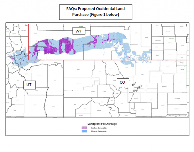
Then there is this... OXY put all of there surface and minerals up for sale last year. WY looked at purchasing it but ended up backing out. So there was an opportunity but no appetite.

The debate on here ranged from, they should buy it to, waste of tax payer money, to it's currently owned by a giant corporation that doesn't enforce trespassing so I hunt there all the time and haven't go in trouble yet.
1617112313937.png
 
@Dakotakid TLDR you can Nickle and Dime access for the next 40 years like RMEF has, and they do great work not nocking them, but the only way access with meaningfully change is if a group of politicians say, it's our land we are going to access it, and force access to all parcels legislation.

So yeah, that's why your going to get 1,200acre easements, and 2,560 acre swaps but no real change.
 
@Dakotakid the other issue is that what your asking for is possible and has been done in aggregate. The problem is it gets really complicated to do detailed work.

With about 20-100 hours of work and a 20k budget I could purchase all the data to give you a really good catalog of parcels in the west. The problem is my analysis would be essentially looking a where roads or trail intersect public lands.

There are thousands of easements that this analysis would leave out because they are proscribed or only exist in a filing cabinet on a paper map in a field office in Montana. Further, how do you define access? People talk about unit 25 in WY having limited access. There is a massive piece of BLM that only has 2 points of access. So yes if you want to walk in 15 miles you can hunt it, but is that access? There is a road that goes through the whole thing, but it crosses like 400 yards of private and is shut down.

Here's one just outside of Denver. Everything below that red x is almost impossible to access.

View attachment 178915

Public land cross the road, and the slope aspect is such that you could park there, but the landowner has a gate just before (167 yards) before you get there. So you can drive 1/4 a mile through is property, green arrow, but he "conveniently" has a gate just before public access. 😲 That can't be on purpose, he definitely wouldn't fight tooth and nail to make sure no one can ever access that area.
View attachment 178919

How do you bucket that access? Can you currently access that spot legal from a trailhead, yes, is it practical no.

Then we have the whole crazy mountain deal, where there has been this giant pitched battle about access with both sides private and USFS having different stories.

How do you map that? What color do you want me to make that on the map, purple for complicated a f-


Then there is this... OXY put all of there surface and minerals up for sale last year. WY looked at purchasing it but ended up backing out. So there was an opportunity but no appetite.

The debate on here ranged from, they should buy it to, waste of tax payer money, to it's currently owned by a giant corporation that doesn't enforce trespassing so I hunt there all the time and haven't go in trouble yet.
View attachment 178922

So true, though I really wish OnX would have released that data to the public in the form of a web map.

In my experience, few things supercede local knowledge. On my long list of things to do is to perform a fresh statewide analysis for Montana (the data is all free here), create a publicly available web application displaying the data, and let folks start to tell me what I missed, or incorrectly attributed as accessible, and why. Over time that dataset would become more reliable. Person X would see that Parcel Y has been listed as inaccessible by Person Z, and maybe person X would know of an old ROW or county easement that actually does access Parcel Y (that is, if they were willing) .

I think some really powerful things could be done on a statewide scale if we crowdsourced the status of questionable accessibility. As an example, in the county in which I live, there are about 5,000 acres of BLM that have always been thought to be inaccessible, even by the agency that manages them, to which an old county ROW exists and is utilized by a few in the know. I think there are more examples like this out there.
 
So true, though I really wish OnX would have released that data to the public in the form of a web map.

In my experience, few things supercede local knowledge. On my long list of things to do is to perform a fresh statewide analysis for Montana (the data is all free here), create a publicly available web application displaying the data, and let folks start to tell me what I missed, or incorrectly attributed as accessible, and why. Over time that dataset would become more reliable. Person X would see that Parcel Y has been listed as inaccessible by Person Z, and maybe person X would know of an old ROW or county easement that actually does access Parcel Y (that is, if they were willing) .

I think some really powerful things could be done on a statewide scale if we crowdsourced the status of questionable accessibility.
Yeah I was thinking the same thing.

"OnX access"

Create an editable versioned public layer that allows feature and attribute table access, to a polyline and polygon feature class.
Crowd source the project, anyone with an OnX subscription can login and flag a parcel as landlocked, or draw in a road segment/trail that has an easement. Allow the person to write notes and/or upload .pdfs

Then allow regional volunteers, backend access to the feature service. There have got to be enough BHA/TCRP members with an Arc licenses, or open source experience that we could pull in that data in and clean it up. I mean if there are 5+ people on HT with an Arc license there have got to be more in the broader community.

Then on a quarterly or so basis someone at OnX could reconcile the data into the parent version.
 
Last edited by a moderator:
Is a ballot initiative an option?

I don't think so. The kind of legal analysis necessary to properly write one so that it doesn't infringe on constitutional rights would be prohibitive, and you may not like what comes out of that process, plus you could still go through all of that, and need to spend a million or so defending it against legal challenges if it passes.

If an initiative is the way to go, go bigger & fix a bunch of issues, rather than focus on one tiny issue with a winding path to resolution.
 
@Nameless Range non sequitur but crowd sourcing related... that moment when you realize how much more accurate USGS, BLM, and USFS trail maps would be if they just copy pasted out of strava :ROFLMAO:

I guess also protip for e-scouting?


USGS, nope no trail.
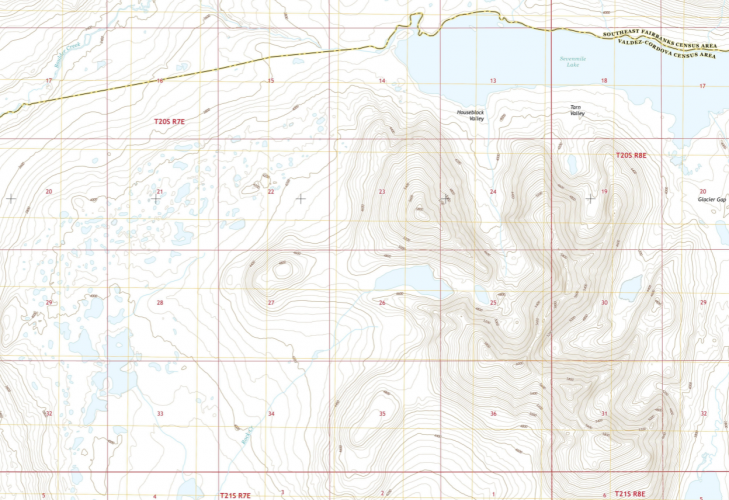
1617114897175.png

Huh... would you look at that...
1617114951424.png

You don't say...

1617115061190.png
 
I guess also... no prescriptive easement you say? Well insta says otherwise.
@Ben Lamb statutorily how many influencers do we need to hike a trail to get an easement? Like if a Kardashian does it then it's just instantly created correct?
 
Thanks for the ton of information. It certainly shows lots of landlocked public land. I have not gotten to an inventory of specific corner crossings.
The first link has a map under the western states that shows landlocked state sections in the little belts. I do not see any access that corner crossing would create.

Rather than nickel and diming, it is asking for specific articulatable parcels that would be affected by legislation, imminent domain or negotiated access.
 
I don't think so. The kind of legal analysis necessary to properly write one so that it doesn't infringe on constitutional rights would be prohibitive, and you may not like what comes out of that process, plus you could still go through all of that, and need to spend a million or so defending it against legal challenges if it passes.

If an initiative is the way to go, go bigger & fix a bunch of issues, rather than focus on one tiny issue with a winding path to resolution.
I have no idea what the ballot initiative rules are in WY (or even if they have that process), but clarifying that corner crossing is not trespass is absolutely not a constitutional issue. This is not a legally complex area and it would take one simple sentence for the legislature to fix. Many states already have this rule (and others) that make incidental trespass less aggressive and pro-landowner. A change in "regulatory scheme" is almost never deemed a constitutional taking. I am not a big fan of ballot initiatives in general, but this could easily be done in a general sense (subject to WY initiative rules).

Changes to terms of public land leases (in new or renewed leases) would also raise no consitutional issues. Would be odd to do this via ballot initiative, but probably no lawful reason it couldn't.

Non-voluntary easements and land swaps would raise eminent domain issues and the commensurate slow/expensive administrative and legal process these entail. I don't see how these could be done by initiative.
 
I guess also... no prescriptive easement you say? Well insta says otherwise.
@Ben Lamb statutorily how many influencers do we need to hike a trail to get an easement? Like if a Kardashian does it then it's just instantly created correct?

I always felt like the kardashian race was forced, in DS9. It didn't seem quite as organic as the Romulans or even the Ferengi.

But legally, no.
 
Thanks for the ton of information. It certainly shows lots of landlocked public land. I have not gotten to an inventory of specific corner crossings.
The first link has a map under the western states that shows landlocked state sections in the little belts. I do not see any access that corner crossing would create.

Rather than nickel and diming, it is asking for specific articulatable parcels that would be affected by legislation, imminent domain or negotiated access.
There are a bunch of different types of access issues I guess is my point.

Likely there are you 80% "value" parcels , huge pieces with good habitat, that you could negotiate for, various groups take a swing at these. RMEF etc. They probably make up <10% of total acreage.

That list probably wouldn't be that difficult to create.

The there is the 90% of the acreage, that consists of millions of sections of BLM with no water, and only have ungulates on them 5 days out of the year. Not much habitat value, not much recreational value. Not worth much... until it's hunting season and you want to disperse 40,000 people.
 
I always felt like the kardashian race was forced, in DS9. It didn't seem quite as organic as the Romulans or even the Ferengi.

But legally, no.
WHAT, no way,

Romans v. Nazi's

I mean if anything in DS9 was forced it was the dominion. I mean Jem'Hadar...

Honestly, after they killed Jadzia my interest declined 85%.
 
Caribou Gear

Forum statistics

Threads
113,574
Messages
2,025,476
Members
36,236
Latest member
cmicone
Back
Top