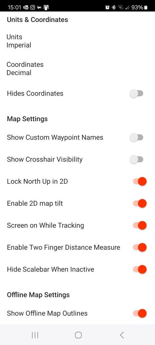
Very good....thank you!Go to your settings and turn off “lock north up in 2d.”
Navigation
Install the app
How to install the app on iOS
Follow along with the video below to see how to install our site as a web app on your home screen.
Note: This feature may not be available in some browsers.
More options
You are using an out of date browser. It may not display this or other websites correctly.
You should upgrade or use an alternative browser.
You should upgrade or use an alternative browser.
Ask your onX Hunt questions here!
- Thread starter Big Fin
- Start date
onX Hunt
Active member
- Joined
- Jul 22, 2013
- Messages
- 436
Would you be able to send over a screenshot of what you're seeing on your end by chance? That will help us to troubleshoot this for you.Negative. No matter how close, the polka dot indicator, sign in boxes and ranch HQ do not show up. It does show the outlining border, but I can’t figure out why it keeps happening when I’m in a BMA. Whether with or without service, saved map or not.
Thanks on the lock north, that helps I’ll let him know
Jmnhunter
Active member
- there an update to MN's aerial photography anytime soon (almost going to hit 6 years soon)?
- Furthermore, leaf-off imagery is available from most counties, along with pictometry
- The ability to download offline maps on the PC so you can use it at basecamp (probably a rare request)
- The ability to adjust the roadless layer--its almost useless in MN where roads are found every 1-2 miles, so if it could be adjusted manually to show based on local criteria's, that would help.
- labels displaying at a certain level would be nice, although I know it bogs things down
onX Hunt
Active member
- Joined
- Jul 22, 2013
- Messages
- 436
-We did recently update Minnesota with newer imagery that is much more current than what we had previously. If you're still seeing older imagery on your map, that could be caused by a caching issue. If you can try clearing the map cache, that should resolve this for you.
- there an update to MN's aerial photography anytime soon (almost going to hit 6 years soon)?
- Furthermore, leaf-off imagery is available from most counties, along with pictometry
- The ability to download offline maps on the PC so you can use it at basecamp (probably a rare request)
- The ability to adjust the roadless layer--its almost useless in MN where roads are found every 1-2 miles, so if it could be adjusted manually to show based on local criteria's, that would help.
- labels displaying at a certain level would be nice, although I know it bogs things down
-We are working to increase our leaf-off coverage. We don't have any ETAs for you at this time, but we're hoping to continue to add more areas with leaf-off imagery.
- We will pass along your requests for offline maps on web map, the ability to adjust the roadless areas layer, and for labels to display differently than they currently do to our engineering folks for them to take under consideration as they build out 2025 plans.
BrentD
Well-known member
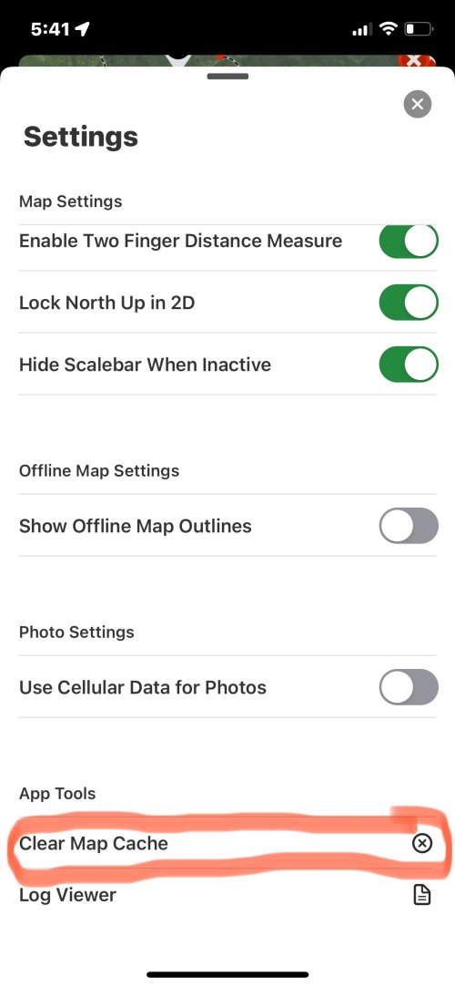
For us Neanderthals, how do you clear the map cache?-We did recently update Minnesota with newer imagery that is much more current than what we had previously. If you're still seeing older imagery on your map, that could be caused by a caching issue. If you can try clearing the map cache, that should resolve this for you.
-We are working to increase our leaf-off coverage. We don't have any ETAs for you at this time, but we're hoping to continue to add more areas with leaf-off imagery.
- We will pass along your requests for offline maps on web map, the ability to adjust the roadless areas layer, and for labels to display differently than they currently do to our engineering folks for them to take under consideration as they build out 2025 plans.
Iowa imagery needs help too.
Khunter
Well-known member
Click the three hask mark in upper left of screenFor us Neanderthals, how do you clear the map cache?
Iowa imagery needs help too.
Click settings
Scroll to bottom of window that pops up
See and tap "Clear Map Cache"
BrentD
Well-known member
BrentD
Well-known member
I went through settings on line and it worked, or at least I found the buttons. No upgraded photos for the property that interests me most  .
.
BrentD
Well-known member
I went through settings on line on my computer and it worked, or at least I found the buttons. No upgraded photos for the property that interests me most.
Khunter
Well-known member
BrentD
Well-known member
I think my version number is 24.44.0 (944)
Android phone, if it matters.
Android phone, if it matters.
onX Hunt
Active member
- Joined
- Jul 22, 2013
- Messages
- 436
That would explain the difference between what you and Khunter are seeing. Android and iOS are different in that aspect.I think my version number is 24.44.0 (944)
Android phone, if it matters.
Just out of curiosity, would you be able to send over a screenshot of an area in Minnesota that appears to have old imagery, along with coordinates? This can be a totally random area, definitely don't feel the need to send an area you hunt. We just want to compare the imagery you are seeing on your side to what we are seeing on our side to see if you are still somehow seeing the old imagery, or if you have the new imagery that we updated to this year.
WapitiBob
Well-known member
@onX Hunt
Other than the missing Wyoming regular and special draw odds breakdown in your hunt research tools, it would be helpful to also add addl filtering options for WY; license type, harvest success, and maybe public land %.
Also. for WY odds where points are averaged, you need to show the individual point pools so guys can see how many are ahead.
Last edited:
onX Hunt
Active member
- Joined
- Jul 22, 2013
- Messages
- 436
Thank you for the feedback! We will pass that along to the team.@onX Hunt
Other than the missing Wyoming regular and special draw odds breakdown in your hunt research tools, it would be helpful to also add addl filtering options for WY; license type, harvest success, and maybe public land %.
Also. for WY odds where points are averaged, you need to show the individual point pools so guys can see how many are ahead.
Carl 9.3x62
Well-known member
Why does my map default to the pronghorn hunt areas everytime I close out Onx or my phone screen turns off? I will have elk hunt areas turned on and it automatically switches to antelope. Yet when I go to switch it back it still says the elk hunt areas are turned on. Also, my hunter management areas layer more or less does the same thing. This is all in Wyoming.
onX Hunt
Active member
- Joined
- Jul 22, 2013
- Messages
- 436
Sorry about the trouble there! I've been trying to replicate this issue on my phone, but have been unable to do so. This definitely sounds like a bug. Please send our customer support team an email so that they can take a look at your account and get this corrected for you. That email address is [email protected].Why does my map default to the pronghorn hunt areas everytime I close out Onx or my phone screen turns off? I will have elk hunt areas turned on and it automatically switches to antelope. Yet when I go to switch it back it still says the elk hunt areas are turned on. Also, my hunter management areas layer more or less does the same thing. This is all in Wyoming.
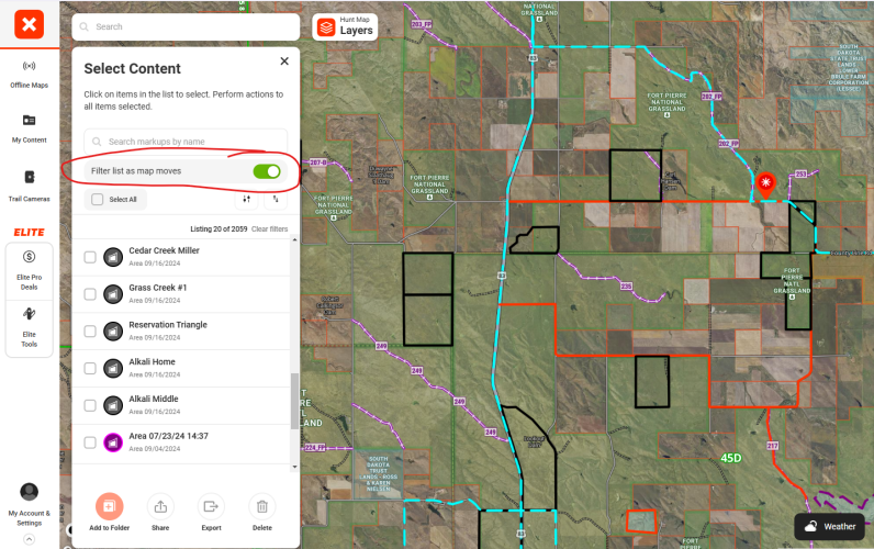
Random question and/or suggestion. It would be great to have a way to multi-select waypoints to add them to a folder rather than having to do it individually.
i've mentally complained about this for years.
then recently realized by going to my content --> select --> click multiple waypoints --> add to folder, it can be done


