Ask your onX Hunt questions here!

It Is there a way to tell which roads are open and when? Example: certain forest service roads that are open from May 15 - December 1.

Is there a way to tell when a road is “private?” This continues to frustrate me as there was a junction and both roads are shown as solid white line on OnX which usually means public road. However when I got there the road was gated. This is only concerning to me when there is public land being gated off which in this case there is.
Check out the MVUM Layer in the Trails & Rec folder as that will show some Road and trail information but unfortunately there are not many good sources of road information that explicitly state whether roads are public or private. We are continually looking for them and are hoping we can find something reliable so we can add this information to the app. Feel free to give us a call at 4065401600 or shoot us an email [email protected]
 
first off, big improvement in the new 3D. Something has been added and I can't figure out. When I click on a property, it outlines that property and draws another outline around a bigger area. below is an example. I can't figure out what it is showing me.
Screen Shot 2021-06-24 at 5.50.41 PM.png
 
first off, big improvement in the new 3D. Something has been added and I can't figure out. When I click on a property, it outlines that property and draws another outline around a bigger area. below is an example. I can't figure out what it is showing me.
View attachment 186580
That is just a minor bug currently, the query card that comes up will still pull up the information for the specific property that you tap on. The additional outline is the bug and is not trying to highlight anything in particular so it will be fixed!
 
Offline maps for the desktop version
Import of geopdf
Display open road and parking areas for TMA areas
Folders for user data organization
 
I just tried to redeem a code I had bought prolly a year or two ago. It will not redeem. I literally just peeled the cardboard off the code so I know I didn’t use it. I tried all the different combos of 1 and l and o and 0. Any ideas?
 
I just tried to redeem a code I had bought prolly a year or two ago. It will not redeem. I literally just peeled the cardboard off the code so I know I didn’t use it. I tried all the different combos of 1 and l and o and 0. Any ideas?
Call into them and they will get it redeemed. I had to do the same thing.
 
Call into them and they will get it redeemed. I had to do the same thing.
Thanks. I got an email response that said they would get it figured out but sometimes they are even quicker on here. Had good luck on here with support before. I am sure they will get it figured out.
 
Thanks. I got an email response that said they would get it figured out but sometimes they are even quicker on here. Had good luck on here with support before. I am sure they will get it figured out.
This page walks through how to redeem a code. Ensure you are not entering it in the promo code box on the purchase page as that is separate from the redeem code but some people mix that up. Codes do not expire so as long as it has not been redeemed before then you can still utilize it. You can also get a hold of us at 406-540-1600 for the fastest response

How to use an onX Hunt Redemption Code
 
Last edited:
I just got onX maps on my IPhone and all I can say is wow. I am mostly a bird hunter and archery deer hunter in Montana. One thing I couldn’t figure out was how to get the Block Management maps. Do we have too wait till they are finalized and out in a few weeks. I am on the free trial week but will be getting the subscription in a couple days. Then will I get Block Management maps? Thanks
 
I use a mini Ipad. The offline maps either lock up, or take hours and hours to load. I live on the north end of Prince of Wales Island, AK, and we don't have cell service on the north half of the island. Offline reliability is a real safety issue in this country! On a hunt last week I turned on the app on Monday afternoon and it didn't load until Tuesday morning about 4:30 am.
 
I use a mini Ipad. The offline maps either lock up, or take hours and hours to load. I live on the north end of Prince of Wales Island, AK, and we don't have cell service on the north half of the island. Offline reliability is a real safety issue in this country! On a hunt last week I turned on the app on Monday afternoon and it didn't load until Tuesday morning about 4:30 am.
Loaded a half dozen maps yesterday, 10mile with sizes all around 250MB. Each took less than 45sec start to finish. This is a definite improvement over last year. Some difference might be the difference between DSL, cell, and broadband speeds?
 
I just got onX maps on my IPhone and all I can say is wow. I am mostly a bird hunter and archery deer hunter in Montana. One thing I couldn’t figure out was how to get the Block Management maps. Do we have too wait till they are finalized and out in a few weeks. I am on the free trial week but will be getting the subscription in a couple days. Then will I get Block Management maps? Thanks
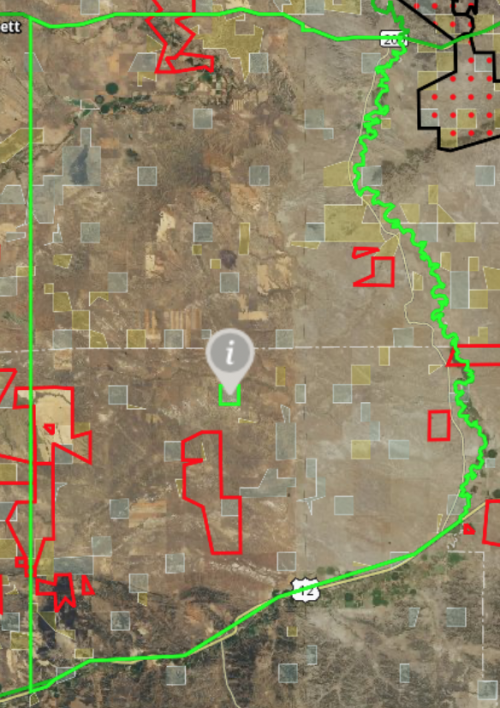
The MT Block Management Layer is always in the App, if you are not seeing it in the My Layers section of the Map Layers menu, go over to the Layer Library, find Montana, then you can add it from there. Keep in mind while this layer is available throughout the year, it is updated as soon as we receive the updated information from FWP which as you mentioned is in early August. If you tap on any Block Management area (indicated by red dots), it will have the end date in the card that comes up, you will see that change once that updated information is available.

Feel free to give us a call at 406-540-1600 if you have any other questions!
 
I use a mini Ipad. The offline maps either lock up, or take hours and hours to load. I live on the north end of Prince of Wales Island, AK, and we don't have cell service on the north half of the island. Offline reliability is a real safety issue in this country! On a hunt last week I turned on the app on Monday afternoon and it didn't load until Tuesday morning about 4:30 am.
As mentioned by @SAJ-99, it sounds like an issue with the service as with a reliable wi-fi/internet connection those maps will download quickly so you will want to ensure that you plan well ahead so those maps can save beforehand. Once those maps are downloaded, we recommend turning your phone to Airplane mode or tapping the 'Go Offline' button in the Offline maps menu as that will force the app to only use those maps you have saved vs trying to connect to service to load them.
 
Pipe dream, but I would love the ability to set a virtual fence that would hit you with a notification when you hit it. For example, trying to learn a new area I could save a shape as a fence and then just go hiking after whatever looks nice without worrying about crossing the boundary by accident.
 
May have been asked before, but couldn't find it. In certain areas, I get the satellite view when zoomed out, but when I zoom in closer, it swictches to a BLM-style map, and I lose the terrain. I fairly recently upgraded to the full nationwide membership, and i THINK I have the layers right, but guessing it is just some setting...would like to keep the ability to see satellite view of terrain at closer zoom, but also be able to toggle back and forth to see trails, etc. better....any ideas on what settings to check?
Thanks
Mark
It sounds like you have the "Forest Visitors Map" Layer turned on. In the MAP LAYERS menu, under MY LAYERS, find the HUNT section, then look for that Forest Visitor Map Layer and tap it to turn it off and you'll get the Satellite imagery at all zoom levels again.
 

Forum statistics

Threads
113,567
Messages
2,025,359
Members
36,235
Latest member
Camillelynn
Back
Top