Leupold BX-4 Rangefinding Binoculars

3D Maps from goHUNT - A few E-scouting tools

I'm curious if onX will feel the need to develop a 3d component eventually. In the meantime I feel committed to it because I don't really want to pay for 2 mapping services, and I have even less interest in transferring the 1,000+ waypoints I have in onX to another platform.
You export waypoints from OnX and put them in GoHunt , takes about 3 minutes
 
Are you just here to pick fights? What value did you add to the conversation?
. . . . . Have you actually be watching Randy's shows for the last few years? When did you last see him using a GPS with a chip? Why do you think you know something here that no one else does?
Man rough crowd on that "trying to be funny" post...jeez Randy always jokes about his inability to keep up with the technology age and how it took him forever to leave that GPS with the chips...guess that joke was only funny years ago...
 
anyone else notice the folder for new mexico layers is missing today?...I suspect they are just working out a few kinks.... Seems like I saw a post where they were adding a feature that pulled up the layers that you had turned on the last time you used the tool. Maybe that is the issue for me... I hope they add a robust help section, FAQ's, etc. I have to admit, it is pretty dang slick so far...
 
NM layers are missing for me too. They had a broken layer that was making private land turn blue in NM, so maybe/hopefully they're fixing it.
 
NM layers are back for me. Looks like they removed the layer that was causing the issue noted above.
 
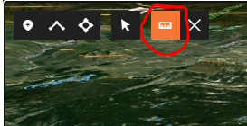
With GoHunt's 3D measuring tool (circled below), I'm starting to find places that can only be glassed from a single, distant (without interfering with thermals) vantage point. This is a big deal since I now know that I can't use the top of a nearby mesa that rises 1,000 or so feet to the south of this area which has a lot of game traffic.

With that tool, I can quickly confirm the only alternative is a knob located to the northwest of this small, high traffic meadow. (Fingers crossed that I found a solid honey hole)

1599675815452.png

Sound's like I'm going to need to reverse-import my way points into Onx at least just for this season.

Also, I'm still using Google satellite since I can see the trails there, but not on Gohunt's satellite imagery.
 
Last edited:
Glad to see the New Mexico layers back as well..... And I have to agree, the aerial on GoHunt is good but I got back in google earth and wow....there is a substantial difference in image quality. I'm still excited about the tool. I'm really curious to see how the mobile version functions with 3D views...
 
I asked them that question some time back and they said that they are working on it.
I asked the same thing when I was loading and updating maps with OnX last month. I was told they had been working on it but GoHunt just released ahead of them. I noticed I have it on my OnX mobil device but last I tried GoHunt I was directed to my computer. Maybe something has changed in the last week.
 
So ive always used an actual gps with a chip in it. Just got the onx app today and i have a stupid question. How the hell do i get a topo overlay? I cant see elevations, but i find it hard to believe that feature isnt on there.
 
The button on the bottom right that says SAT, click it to scroll through the views...
 
This is a bit of a confession. When goHUNT told me they were going to release 3D maps, my response was more of "meh" than it was super excitement. I had always felt comfortable with my ability to look at topo lines in 2D and if I felt I needed comfort, I would log into GE and confirm from that. I just didn't see where 3D would be that big of an improvement.

Now that I have had 3D maps with layers, I have to admit my level of enthusiasm has changed. Over the last two months I have been giving my "wish list" to goHUNT for tools I need when E-scouting on my desktop maps. They have been creating some of those for me to test and they are adding them to the 3D desktop maps.

The end idea of my E-scouting project with them is that every tool I need for E-scouting will be right there on the desktop maps. I don't E-scout from my phone, so I am focused on having these available for my desktop application.

This video has a few of the tools we have come up with since we started this in June. Many more E-scouting tools are on the list, though right now goHUNT is focused on getting the mobile app perfected. As those additional tools are added, I will do videos about them.

Here is a video with a few E-scouting tips I am using for my Colorado 1st Rifle Elk season and demonstration of how some of these E-scouting tools are designed with what an elk hunter needs to build the best possible E-scouting plan. Excited to work with them on a very robust suite of tools that make this task far easier than when I did my first E-scouting seminar in 2013 where the tools available were screenshots of GE and Microsoft Paint.

I might reprimand the editor who came up with that stupid looking thumbnail. All I need is some coke bottle glasses and I could be a stand in as Bubbles on the Trail Park Boys.

Great video!
 
Gastro Gnome - Eat Better Wherever

Forum statistics

Threads
113,686
Messages
2,029,710
Members
36,284
Latest member
Mtelkhunter119
Back
Top