Leupold BX-4 Rangefinding Binoculars

On X Map Dates?

Honestly, the imagery I see on onxmaps looks identical to google earth recently. By identical, I mean I found elk in two different spots and they were on both Google Earth and onxmaps. I would check to see if Google Earth looks the same and then look at the imagery date on there.
 
that would be nice to know along with when the parcel maps were last updated
I think the updates come as the countys recorder updates their changes. I want to say I heard that OnX updated ownership information like 2 times a year.
 
I think the updates come as the countys recorder updates their changes. I want to say I heard that OnX updated ownership information like 2 times a year.

I wish this were true; our county continuously updates their parcel maps (daily-so the county says) here in MN, they sell off tax forfeited lands so before I go scout tax forfeited county land, I have to cross reference the county's gis site.
Last I asked OnX was annually (atleast in MN) and in MN its proving to be alot longer--last year was a good test, we moved to a new place in June and it still hasnt been updated yet. But I know they updated Walk in Areas as those change fall to fall, so perhaps they only update the private layers every 1-2 years (in MN anyhow)
 
Last edited:
My rural property is listed on OnX as still belonging to the previous owner from 3 years ago. The county updated their electronic record within 30 days of the sale. Not sure why OnX is not using up-to-date data
 
Anyone know how to find out the date an OnX aerial photo was taken? I am starting my e-scouting for my AZ elk tag and it would be rad to know this information... at least the month.
Thank you in advance.

The easiest way is to download google earth, and then use the historic imagery slider to find imagery that matches that used by onX.

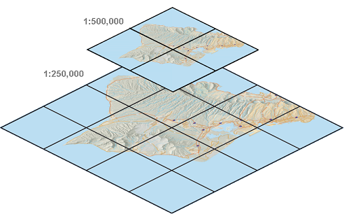
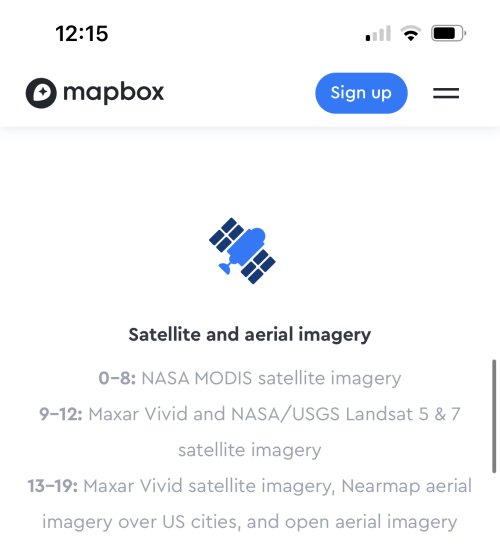
There are a couple imagery services out that that basically all web mapping applications utilize. These are tile services, depending on the scale the imagery comes from different sources. At the highest most zoomed out level is satellite imagery (eg federal satellites) at the most zoomed in level the highest quality imagery is either from drones/ planes (eg.private company or imagery shot by a county). All of these layers are stitched together by companies like digital globe who consolidate the imagery and then package it. OnX buys these imagery services like anyone else, they have zero control over how often it's updated, clouds that distort certain areas etc. They have read only access to a stream, that they add to their map. If their imagery appears better or worse then bing/google/esri it's because they pay for a different level subscription or get their data from a different third party vendor.


1584477048181.png

As far a parcel data goes OnX has really done an amazing job stitching together the country. There are a couple of other companies that have similar layers (ex Whitestar), but as far a nationwide layer OnX is probably the best option on the market. That being said OnX is stitching together data, my assumption is that they are either working with conglomerators like Whitestar or have contracts with individual counties (probably a mixture of both). Some counties will provide them a API that automatically updates their server on a regular basis, some counties might send them monthly or bi annual dumps, and some counties (and I know this from personal experience) only sell their parcel layers ad hoc and mail you a CD or thumb drive that comes with a shapefile and then an access database and it's up to you to join the two and parse out what information you want for each parcel. So, for some folks it might seem like OnX updates are happening in real time, but in other areas it might seem like their hasn't been an update in 5 years. All this kinda depends on the agency (county/parish/etc) or company that is collecting the data, there are a number of counties who are still solely using paper maps and therefore have literally no digital coverage.

Another complicating factor is data licensing, those contracts run the gamut. OnX seems to get around it by only providing the parcel shape and a small subset of the data, and not allowing you to download anything. Point being your county may have specific terms and conditions about how often OnX can get data from them and/or how it can be used.

Data comes in more or less three pieces the shape, the projection, and the attribute table. OnX has to take data from all these sources, put them in the same projection, standardize the table, and then append the data. The difficulty of this task greatly depends on what condition the data is in when you get it, some of it likely is pretty clean and just has to be loaded in a database, some of it is probably a dumpster fire and takes a lot of effort to correct before it can be loaded.

I'm a GIS Professional and just trying to give some context of how this all works, this may or may not be exactly what OnX is doing.
 
The easiest way is to download google earth, and then use the historic imagery slider to find imagery that matches that used by onX.

There are a couple imagery services out that that basically all web mapping applications utilize. These are tile services, depending on the scale the imagery comes from different sources. At the highest most zoomed out level is satellite imagery (eg federal satellites) at the most zoomed in level the highest quality imagery is either from drones/ planes (eg.private company or imagery shot by a county). All of these layers are stitched together by companies like digital globe who consolidate the imagery and then package it. OnX buys these imagery services like anyone else, they have zero control over how often it's updated, clouds that distort certain areas etc. They have read only access to a stream, that they add to their map. If their imagery appears better or worse then bing/google/esri it's because they pay for a different level subscription or get their data from a different third party vendor.


View attachment 131428

As far a parcel data goes OnX has really done an amazing job stitching together the country. There are a couple of other companies that have similar layers (ex Whitestar), but as far a nationwide layer OnX is probably the best option on the market. That being said OnX is stitching together data, my assumption is that they are either working with conglomerators like Whitestar or have contracts with individual counties (probably a mixture of both). Some counties will provide them a API that automatically updates their server on a regular basis, some counties might send them monthly or bi annual dumps, and some counties (and I know this from personal experience) only sell their parcel layers ad hoc and mail you a CD or thumb drive that comes with a shapefile and then an access database and it's up to you to join the two and parse out what information you want for each parcel. So, for some folks it might seem like OnX updates are happening in real time, but in other areas it might seem like their hasn't been an update in 5 years. All this kinda depends on the agency (county/parish/etc) or company that is collecting the data, there are a number of counties who are still solely using paper maps and therefore have literally no digital coverage.

Another complicating factor is data licensing, those contracts run the gamut. OnX seems to get around it by only providing the parcel shape and a small subset of the data, and not allowing you to download anything. Point being your county may have specific terms and conditions about how often OnX can get data from them and/or how it can be used.

Data comes in more or less three pieces the shape, the projection, and the attribute table. OnX has to take data from all these sources, put them in the same projection, standardize the table, and then append the data. The difficulty of this task greatly depends on what condition the data is in when you get it, some of it likely is pretty clean and just has to be loaded in a database, some of it is probably a dumpster fire and takes a lot of effort to correct before it can be loaded.

I'm a GIS Professional and just trying to give some context of how this all works, this may or may not be exactly what OnX is doing.
The problem is OnX is probably using ESRI creating a time crunch since esri is horrible to process large datasets:LOL:
Global Mapper or Mapinfo(y)
 
My rural property is listed on OnX as still belonging to the previous owner from 3 years ago. The county updated their electronic record within 30 days of the sale. Not sure why OnX is not using up-to-date data

Historically we update each state once a year, we are implementing a system that will allow us to update more frequently. We do work with the counties as well as state/federal agencies on obtaining our information but unfortunately some counties are more willing to work with us than others when it comes to acquiring their information so we can implement it in the app. So it could come down to a couple things for why it isn't updated. We're more than happy to look into your property if you tap on it in the app then select Report Error this will go to our team to look into and work on getting updated. If you have any other questions give us a call at 406-540-1600 or email [email protected]
 
Historically we update each state once a year, we are implementing a system that will allow us to update more frequently. We do work with the counties as well as state/federal agencies on obtaining our information but unfortunately some counties are more willing to work with us than others when it comes to acquiring their information so we can implement it in the app. So it could come down to a couple things for why it isn't updated. We're more than happy to look into your property if you tap on it in the app then select Report Error this will go to our team to look into and work on getting updated. If you have any other questions give us a call at 406-540-1600 or email [email protected]
Thanks I didn’t know about the error feature - I just submitted one
 
Onx uses google earth for their max resolution and only when online. Less magnification and offline used to be esri world imagery.
 
I think the updates come as the countys recorder updates their changes. I want to say I heard that OnX updated ownership information like 2 times a year.
This isn't the case. Onx goes years in between their ownership updates. I have family that bought 300 acres four years ago and it's still listed under the previous owner on Onx. It's identified correctly on BaseMap, though.
 
The easiest way is to download google earth, and then use the historic imagery slider to find imagery that matches that used by onX.
I’m going to refresh this question and tag @onX Hunt. What @wllm describes is cumbersome and shouldn’t be necessary. If memory serves correct (and it often doesn’t) onX used to have a date tag on the images, but that seems to have gone away. Is that date tag available anywhere in Onx so it can be easily applied?
 
Everything is just too dang easy and convenient now. I don’t mind it being cumbersome at all. I would argue that the single most greatest hunting advantage is mapping technology and apps like OnX. It’s not gear, clothing, weapon technology or anything else. It’s the ability for an individual to pick up their phone and follow their blue dot into areas they’d never consider going with a paper map and compass. Having said this, I am an OnX subscriber and I take full advantage of the technology. However, I’m also a millennial that knows how to navigate using a map and compass.
As for the date of imagery. I primarily use google earth for my planning because you can view a variety of dates to see the information you desire. I then transfer that data into onx. I know it’s an extra step, but it’s no biggie
I agree on how tech and maps has changed the sport. All I really want to know is when the picture was taken. I don’t need all the history Google Maps has. Just that piece of info. It’s not going to change where or how far I go.
 
I’m going to refresh this question and tag @onX Hunt. What @wllm describes is cumbersome and shouldn’t be necessary. If memory serves correct (and it often doesn’t) onX used to have a date tag on the images, but that seems to have gone away. Is that date tag available anywhere in Onx so it can be easily applied?
I'm not sure if OnX is purchasing imagery directly or just using, Bing/Google/ESRI/Mapbox if the later they likely don't acutally have the capability to provide the date as the imagery is provided as a service from a third party vendor.

I can't provide our folks with dates on the imagery on the map I build. Now if I had someone fly our sites with drones/planes and built a tile service I could provide the dates on that imagery.
Matching up dates is more difficult than it seems. I can see a truck in one photo but not in any of the dated photos in Google Earth. Sometimes vehicles seem to disappear. Saw two trucks at a specific point on the OnX photo last night, but this morning can't see them. Maybe they are not using Google Earth photos, maybe they have some sort of algo that erased the vehicles on some of these roads? No idea.
 
Use Promo Code Randy for 20% off OutdoorClass

Latest posts

Forum statistics

Threads
114,237
Messages
2,049,258
Members
36,523
Latest member
blacksith_81
Back
Top