Advertisement

How to monitor burns for potential future hunts?

2rocky

Well-known member
Joined
Jul 23, 2010
Messages
5,137
I'm watching fires in several states this year and I'm wondering what the best way is to research how they recover from an elk hunting standpoint. I can't go personally check out the landscape in each one, but my gut tells me that in 5 years or less these burns may hold elk.

Is there a sweet spot in burn age between lush grass growth and pickup stick deadfall and head high brush? Is there a time point in recovery where you know if the fire was too hot and sterilized the soil?
 
I don't have the link right at my fingertips, but burn intensity maps are sometimes available online. I've used them in the past for mushroom hunting purposes, making sure the soil won't be scorched to sterilization before I hike into a place.
 
Think its pretty specific to the burn time (time of year the burn was), grazing intensity, weeds in the area, rain in subsequent years, heat, etc.

Feel as though it'll be a struggle without a boot on the ground.
 
Thanks!

So looking at the severity layer, I presume red and probably yellow means the fire burned too hot to support natural re-veg?
That was my question as well. All the burn areas seem to be red. So I'm guessing there is a legend or layer I'm overlooking...
 
I’ve just looked at their written post-fire assessments for that info. I believe they only produce those for larger fires though. I’ll mess around with the site in a bit and see if I can get it figured.

Also going to page @Nameless Range on this one. I might be mistaken, but believe his vocation involves GIS expertise?
 
Alrighty. There's a few ways to get what you guys are looking for. I got both of these from the homepage that has four options. Search Data, Get Data, Analyze Data, & Data Availability. I think their site is FAR more powerful than what I found messing around for a few minutes, but here's the basics insofar as I can tell.

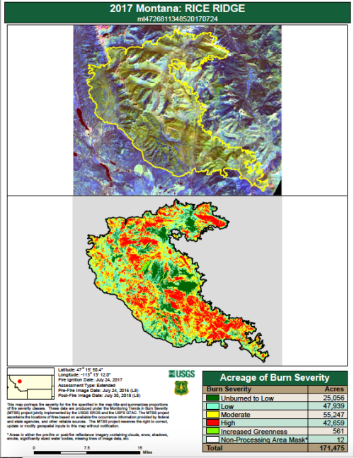
1) Interactive Map: Set your parameters, click on a fire, then enter your email for a "fire bundle download." This will send you a bunch of files that you could use in Google Earth or another mapping application. It'll also have a PDF of the fire intensity. Here's one for Rice Ridge.

Screen Shot 2024-09-16 at 6.22.44 PM.png

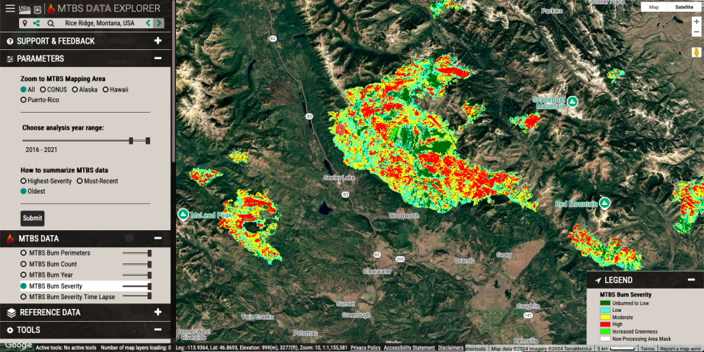
2) Data Explorer: Enter parameters again and it'll show you a pile of fires. Unfortunately they're not all labeled with the name. But if you know where you're looking it'll show you a map and you can deduce.

Here's Rice Ridge again.

Screen Shot 2024-09-16 at 6.23.10 PM.png

Hope that helps get you started!
 
Back
Top