East Troublesome Fire - 2020 to now info needed

bmontang

Member
Joined
Dec 24, 2017
Messages
97
So my group just found out we drew our second choice for Colorado elk this fall - Unit 18 1st season. The biggest redeeming quality is the tags are either sex, so we should be coming home with meat. Looking at what I can find so far, the East Troublesome fire seems to have burned the entire unit. I know the quota in 18 is 840 tags for first rifle (per CPW site). What I am trying to figure is how burned out the unit is. I can't seem to find recent satellite images that zoom in close enough to tell what is burnt and what is not.

I am not looking for any honey holes or anything else, but I would really appreciate help in zeroing in on imagery sources. I have an OnX subscription, what I can't tell is what the dates of their images are. Like I said I can do my own leg work if pointed in the correct direction (not that I would refuse PMs with the coordinates of big bulls lol).

TIA
 
In OnX:
Layers -> Western App Research -> Historic Wildfire

Or are you looking to discern burned/unburned areas withing the perimeter?
 
In OnX:
Layers -> Western App Research -> Historic Wildfire

Or are you looking to discern burned/unburned areas withing the perimeter?

Trying to figure out what happened within the perimeter. When you turn on historic wildfire its pretty much the whole unit. I know wildfires well enough to know that can't be the real case. There has to be pockets that survived.

Thank you though.
 
Trying to figure out what happened within the perimeter. When you turn on historic wildfire its pretty much the whole unit. I know wildfires well enough to know that can't be the real case. There has to be pockets that survived.

Thank you though.
If it's on National Forest or BLM you could ask them if they have a burn severity map of the fire, a lot of the bigger fires have them but sometimes difficult to get ahold of.
 
there is a burn severity map.

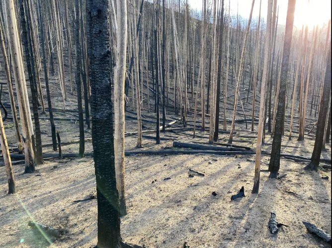
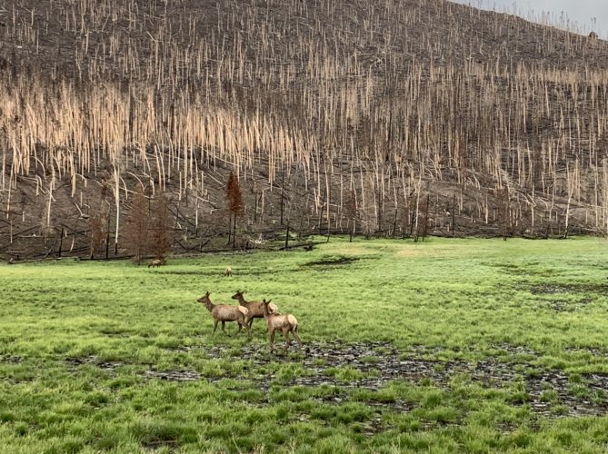
and i was there last fall. there are sporadic pockets of new growth. and pockets of unburned timber.

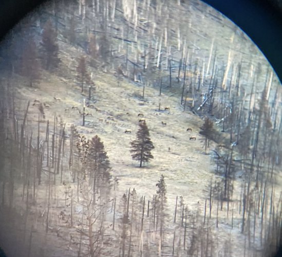
but holy shit was that a hot fire. it's a wasteland in much of it. go searching for that burn severity map and focus on the edges of the burn area. plenty of elk in there.

51313.jpg

65153.jpg
 
there is a burn severity map.

and i was there last fall. there are sporadic pockets of new growth. and pockets of unburned timber.

but holy shit was that a hot fire. it's a wasteland in much of it. go searching for that burn severity map and focus on the edges of the burn area. plenty of elk in there.

View attachment 224761

View attachment 224762
Togie thank you very much. I will find the map you referenced. I am going to try to get up there for a week this summer but with gas prices and what not I am not sure. e-Scouting will be paramount but I need to start with the non-moon wasteland areas.
 
You may want to pick up some black sweats at Walmart for your camo. And you may want to re-think your presumption that "some of it has to be OK". Where the wind got to 70 MPH there is nothing left (and this is the majority of the burn). No horizontal branches on black toothpicks type cover.

No grass just a foot plus of ash no topsoil for any regeneration. I've read the same stuff... "burns are good and lead to a fresh start." This fresh start is gonna be pretty good at somewhere around 2050. Now divide the few hundred green acres by the 1500 -2000 tags, might resemble a halloween theme pic, orange and black.

The good news is CPW says only a few elk burned up, the bad news is they are full of elkshit, winter range has been empty for the last two years.

Area chief told me that is because there is so much green in the burn they no longer need the winter range, the first winter it grew so quickly after the fire that they stayed right there and got fat. I pointed out that a week after the fire it was -10 degrees and I did not re-call having to mow my lawn that late, and my lawn didn't burn. His response was "we have helicopters, you don't". They are still issuing class "b " cow tags.

Do you think that helicopter footage of a huge elk herd that first winter was released for a reason maybe? (Actually it wasn't even that big but was almost certainly the best they could come up with)

Last summer the creek was flowing like the effluent from a septic tank discharge. I dont filter and I had to ask my buddy to filter me some and it was still terrible tasting stuff. This spring it is looking much better, time will heal this, quakies are gonna love it for the next 50 years or so.

You may want to visit before the "turn in tag" window expires.
I was up unit 18 last year and they had most roads close west of Hwy125 but they did open Still Water Rd for hwy 125 to Grand Lake. I got on North Supply Rd and they were seeding burn area by Helicopter.

Since I also drew rifle first season either sex elk tag for unit 18, I wouldn't advise any one to turn in since it also include unit 181. I drew archery deer for all units in middle park and I get archery cow tag that include 18/181 so I can do some scouting for bull.
 
there is a burn severity map.

and i was there last fall. there are sporadic pockets of new growth. and pockets of unburned timber.

but holy shit was that a hot fire. it's a wasteland in much of it. go searching for that burn severity map and focus on the edges of the burn area. plenty of elk in there.

View attachment 224761

View attachment 224762
The burn severity map is the best. Then you can use on x or go hunt and pin point where it wasn’t as bad or maybe more mosaic. This helped us immensely with a similar fire. The elk definitely used the less burnt areas.
 
There is 646 sq miles in unit 18 or 413,237 acres. There is sections that never burn The north border of 18/181 is Continental Divide and goes south at Rocky Mountain National Park. Unit 17 and 171 south border is unit 18.181. There is places you can cross into 18 from 17/171. You normally have hunters that hunt east side of HWY 125 and others that west side. The south border 18 is hwy 40 and go from Granby to Kremmling never know there was fire in 18. I've hunt east side but was Never Summer Wilderness. Now that they figured someone started fire may open it up
 
You may want to pick up some black sweats at Walmart for your camo. And you may want to re-think your presumption that "some of it has to be OK". Where the wind got to 70 MPH there is nothing left (and this is the majority of the burn). No horizontal branches on black toothpicks type cover.

No grass just a foot plus of ash no topsoil for any regeneration. I've read the same stuff... "burns are good and lead to a fresh start." This fresh start is gonna be pretty good at somewhere around 2050. Now divide the few hundred green acres by the 1500 -2000 tags, might resemble a halloween theme pic, orange and black.

The good news is CPW says only a few elk burned up, the bad news is they are full of elkshit, winter range has been empty for the last two years.

Area chief told me that is because there is so much green in the burn they no longer need the winter range, the first winter it grew so quickly after the fire that they stayed right there and got fat. I pointed out that a week after the fire it was -10 degrees and I did not re-call having to mow my lawn that late, and my lawn didn't burn. His response was "we have helicopters, you don't". They are still issuing class "b " cow tags.

Do you think that helicopter footage of a huge elk herd that first winter was released for a reason maybe? (Actually it wasn't even that big but was almost certainly the best they could come up with)

Last summer the creek was flowing like the effluent from a septic tank discharge. I dont filter and I had to ask my buddy to filter me some and it was still terrible tasting stuff. This spring it is looking much better, time will heal this, quakies are gonna love it for the next 50 years or so.

You may want to visit before the "turn in tag" window expires.


Looking at the burn severity map it isn't quite as bad as you suggest or the map is dead wrong. I do know the tag count is ~850 for first rifle not 1500-2000. I am definitely going to try to get up there, just not sure I can. I am thinking there are going to be lots of edge areas to glass and work.
 
Looking at the burn severity map it isn't quite as bad as you suggest or the map is dead wrong. I do know the tag count is ~850 for first rifle not 1500-2000. I am definitely going to try to get up there, just not sure I can. I am thinking there are going to be lots of edge areas to glass and work.
Burn severity is usually referring to "soil" burn severity, so even moderate severity can appear to be quite severe in terms of vegetation obliteration and recovery, especially when seed sources are limited due to slow vegetation recovery over large areas. The maps are based on satellite imagery that should be ground corrected to produce the final severity map, but not perfect and large fires with variability in prefire condition can be difficult to correct very accurately, so grain of salt with the map.
 
Looking at the burn severity map it isn't quite as bad as you suggest or the map is dead wrong. I do know the tag count is ~850 for first rifle not 1500-2000. I am definitely going to try to get up there, just not sure I can. I am thinking there are going to be lots of edge areas to glass and work.
That 850 is the EE code right? Yes I would go with the computer info if I were you. Good luck on your adventure.
 
Burn severity is usually referring to "soil" burn severity, so even moderate severity can appear to be quite severe in terms of vegetation obliteration and recovery, especially when seed sources are limited due to slow vegetation recovery over large areas. The maps are based on satellite imagery that should be ground corrected to produce the final severity map, but not perfect and large fires with variability in prefire condition can be difficult to correct very accurately, so grain of salt with the map.
So they don't even pretend to sample with boots on the ground? I was curious when in the dead of December in -25 temps they came out with minimal soil damage for the entire burn. I was talking to a guy and we both were incredulous that lazy gov't slugs had penetrated deep into the back country and determined pristine conditions for re-growth in under 60 days under extremely adverse conditions.

When I was kicking into the ash it was 6-20" deep and both copper and aluminum had melted only steel and alloys had withstood. Nothing but mineral soil and stump holes, even the root balls had burned out, especially on the ridge tops and the west facing upslopes given the 70 mph winds.

Last summer you could walk miles without even seeing a weed let alone all the "lush green re-growth" that was what computer models promised. People hear what they want to believe, OTC was nutso with people flocking to hunt "the burn". Hell I've read just that on here many times.

10' of beetle kill logs with high winds, even some people with police escort cooked, yet near zero elk perished. Thats almost unbelievable yet it is officially true. Has to be.
 
Looking at the burn severity map it isn't quite as bad as you suggest or the map is dead wrong. I do know the tag count is ~850 for first rifle not 1500-2000. I am definitely going to try to get up there, just not sure I can. I am thinking there are going to be lots of edge areas to glass and work.
My bad. 1320+ tags. Painted with too broad of a brush, plenty of edge for allofya
 
So they don't even pretend to sample with boots on the ground?
I think my wording was confusing, a proper final severity map will be ground truthed, this work usually happens right after the fire, the more complex the prefire conditions (like forest and rangeland and ag in same fire), the more difficult to ground correct. In my experience actual fire severity often doesn't match most people's perception of severity, once you start looking across the entire burn, the high severity stuff just really catches your eye. But I have zero knowledge of this burn.
 
8498D924-5DA1-436D-9DEC-119852ADEFD2.jpeg

This is RMNP near Grand Lake on the fringe of Unit 18, photo taken yesterday, this was part of the Troublesome Fire. As you can tell there’s areas that won’t have productive soil for years.

The places that didn’t burn were highly concentrated with hunting pressure last season since most of the units were closed.

It’s not an easy hunt - the burn further complicated things. Lots of blow down and beetle kill
 
View attachment 225082

This is RMNP near Grand Lake on the fringe of Unit 18, photo taken yesterday, this was part of the Troublesome Fire. As you can tell there’s areas that won’t have productive soil for years.

The places that didn’t burn were highly concentrated with hunting pressure last season since most of the units were closed.

It’s not an easy hunt - the burn further complicated things. Lots of blow down and beetle kill
Problem you have is Grand Lake is eastern border unit 18. If you go over Still Water pass it's differ going west. They done some clear cutting beettle kill vs tourist town like Grand Lake.
Before fire FS and clear cut off Kauffman Creek east side hwy 125.

I do like Grand Lake during summer we'll go up during week stay in town hike in park and do little shopping.
 
That 850 is the EE code right? Yes I would go with the computer info if I were you. Good luck on your adventure.
The 850 (actually 840) was off memory and either sex from the published draw results info for 2021 - https://cpw.state.co.us/Documents/Hunting/BigGame/Statistics/Elk/2021ElkDrawRecap.pdf

I did neglect to add in the 480 cow tags so for first season the total tags issued in 2021 according to CPW's data was 1,330. The burn makes the unit way less than ideal, but with an either sex tag I am at least a little hopeful there will be elk in the freezer this year.
 
Having hunted in the high park fire burn area a few years after it burned, I can say that there will be a lot of areas that are absolutely toasted into moonscape. It will probably take longer than our lifetimes to rebuild the soil profile in the massive burns like the troublesome, high park, Cameron peak etc.
But there will also be unburned places and there will be elk! I saw the results of a collar study that showed the elk moving around fires and surviving. I’m sure there are some that die, but not all or even most of them.
Keep us updated and let us know how you do! Best of luck!
 
Kenetrek Boots

Latest posts

Forum statistics

Threads
114,019
Messages
2,041,296
Members
36,430
Latest member
SoDak24
Back
Top