Dams That Never Were

Do your irrigation districts have tiered rates? Municipalities frequently have tiered rates over here, but the irrigation districts I'm familiar with are all flat on a per acre basis. Nobody knows how much water they use.

irrigation districts i wouldn't know.

the ditch companies certainly don't. they have assessments to pay for ditch maintenance and some employees but otherwise it's your water right thats kinda just held in trust by the ditch company.

however, our measurement rules are extremely robust and very much enforced. we largely have a good handle on how much water is being used by anyone out here.
 
LOL. Legislatures. You would think they could Google “energy to move a gallon of water up 100 ft” before saying something stupid.


the Arizona state legislature passed a measure in 2021 urging Congress to investigate pumping flood water from the Mississippi River to the Colorado River to bolster its flow.
I mean, it only seems stupid now because of all the cheaper and easier options, but it's definitely possible, and honestly will almost certainly happen at some point to some degree. What I really don't understand is that CO keep allowing CO River water to go east out of basin. That's just making the situation worse.
 
What I really don't understand is that CO keep allowing CO River water to go east out of basin. That's just making the situation worse.

well, in this regard, the biggest reason it keeps happening is it's a matter of the water rights system.

the colorado constitution doesn't prohibit water to be taken out of its native basin, regardless of the scale of the basin to basin transfer. it just so happens the colorado river basin is one that makes big headlines in this regard. these are aspects of colorado water law that won't be touched by the legislature due to upending the entire system and the courts will continue to interpret those aspects of water law as they always have been. and that is the right that comes with it, the right to use that water for it's decreed beneficial uses, even if it's out of basin.

but of course there are other ways ways to reject the movement of more water out of basin, such as getting projects vetoed by the feds or using your local governments to put up impassable hurdles to such projects. but the water will largely continue to flow east for those with decreed water rights to do so.

a lot of people on the front range don't realize that if they live north of pueblo and east of the continental divide, in very ver general terms their water is 50/50 mix of colorado river water and south platte basin water. and that is a shit ton of homes and farms using a shit ton of colorado river water. small beans though in the big scale of total flows to powell though, let's be honest.
 
these are aspects of colorado water law that won't be touched by the legislature due to upending the entire system and the courts will continue to interpret those aspects of water law as they always have been.
Feels like we can only deny reality for so long? To the OP, there will be more dams in places we don't like because you often can't place an adequate $ value these places regardless of how unique and beautiful they are.
 
Feels like we can only deny reality for so long? To the OP, there will be more dams in places we don't like because you often can't place an adequate $ value these places regardless of how unique and beautiful they are.

I do think the days of damming rivers to create reservoirs are basically over though.

But yeah, other types of storage projects, there will be more.
 
Do your irrigation districts have tiered rates? Municipalities frequently have tiered rates over here, but the irrigation districts I'm familiar with are all flat on a per acre basis. Nobody knows how much water they use.
Yes, but not based on use, typically based on type/age of your share. Most districts are seeing less use from the initially authorized/served areas due to development and irrigation efficiencies, so they'll take that extra water and issue leases or new shares at higher rates and with junior status. In terms of actual water use, yeah it's pretty vague on the user side. They know very well how much is diverted, both by the system and by each user, but actual "use" not well understood.
 
Thought about this thread this weekend. For the first time in my life, we went and goofed off on Noxon Reservoir, one of a few dam-created lakes on the Clark Fork River. We went with some friends who, unlike me, own a boat – though I am 90% of the way to convincing my wife we need one.

View attachment 284477


With someone with a different take, I had a good long conversation about dams. In particular the Paradise Dam that was never built, but would have turned most of the lower Flathead River into the 3rd largest waterbody in Montana.

In mapping dams that never were, and celebrating free flowing rivers, I kind of wonder if I and others are too biased against dams. I am certainly not advocating for the creation of any new dams, which would be logistical and social nightmares, and I do wonder about the things we are missing, whether it is the stuff we know – like the effect of the Snake River Dams on fish, or what we don’t. but I would not be surprised if many of the dams that never were would be celebrated today if they had come to fruition.

If you polled the residents of Helena about whether they would want the near by dams of the Missouri removed in the name of cottonwood riverbottom and free flowing water, I’d bet most would prefer the lakes. Part of that is that lakes almost seem more, “utilitarian”. Near everything most do on a river you can do on a lake and then some, but another part of it may be that, because lakes and water belong to all Montanans, it literally creates more “access” in both literal acreage, and possibility. Even consider the OP of this thread. Allenspur Dam would’ve buried thousands of acres of elk and deer habitat, and dammed the longest free flowing river in the U.S. – something I am personally glad did not happen. But then again, it would’ve created a big damn lake everyone could enjoy where now sits a hell of a lot of McMansions and Dude Ranches few do.

I suppose the opposing part of the conversation's perspective, which I am kind of sharing here, is not the prevailing wisdom on this site or even in my mind, but there’s a devil needing his due – the lake that the Paradise Dam, for example, would’ve backed up would’ve been an interesting beast – whether it be the goodness of tailwater fishing, flood control and power generation, or the discussion of whether or not lakes >rivers when it comes to economic boosts for rural communities.

I’m not saying I am bummed that many of the dams in this thread didn’t come to fruition, nor am I opposed to the trend of removal of dams in the name of fish and wildlife, just thinking out loud that reservoirs have the ability to provide their own value and are interesting human achievements and that I suppose those things should be a part of the conversation about Dams That Never Were.

Obligatory Hunt Talk sweatshirt and sunset photos. Noxon Reservoir is a pretty place:

View attachment 284475

View attachment 284476

Next time you are up in that neck of the woods, hit me up. I live right on Noxon Reservoir. I do enjoy the reservoir, but I am more of a non motorized river recreationist. Despite living less than 50 yards from the reservoir and having access to a boat tied to the dock in front of my house, I spend way more of my free time rafting rivers or fishing local creeks. Its just hard for me to relax and enjoy being outside with the ever increasing loud rumble of bass boats and wake boats zooming around and blasting terrible music on their speakers. The amount of trash I find on the bank in front of my house and during my walks along the shore is also discouraging and increasing every year.

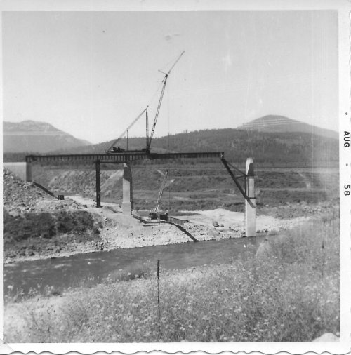
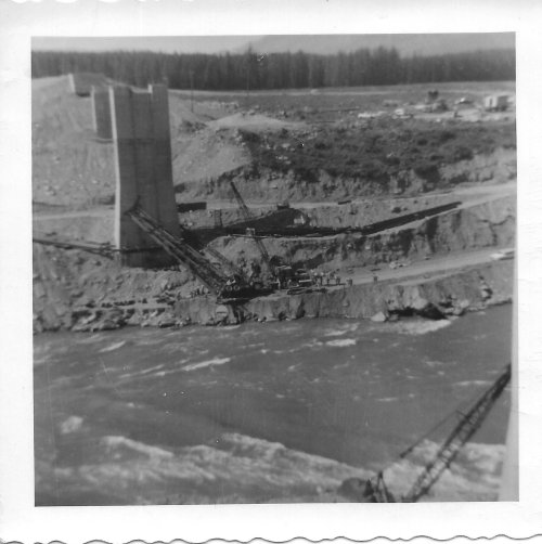
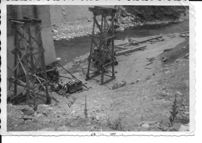
I got ahold of these old pictures of the Hwy 200 Trout Creek Bridge being build while the Noxon dam was also under construction.
92670625_1157010407972056_7085330509382811648_o-1.jpg

92747355_1157010867972010_2550110121598386176_o.jpg

92876202_1157010564638707_8876386241805811712_o.jpg
The reservoir has been here long before I was born and it is all that I have ever known of this stretch of the Clark Fork. My great grandfather spent much of his life post WW1 working in the woods. He was the local district ranger for the forest service for a short time then became a game warden for the rest of his working life. I have read some of his old diaries and the stories he has of floating down the river between Thompson Falls and Noxon catching poachers using dynamite and nets to catch spawning bull trout. Sounds like it was quite a beautiful gorge with some good whitewater in spots. Makes me sad that myself or anyone else will ever get to see and enjoy that place that no longer exists. Its a second kick to the gut to know that none of the electricity generated by the two major dams along this stretch of Montana river is sold to Montana customers. It all goes out of state. Although, I will say that the power company that owns the dams and most of the shoreline of the reservoirs does spend quite a bit of time and money on habitat improvement projects and mitigation for the impact of their activities on fish and other wildlife.

Got to say that I am extremely glad that the Paradise Dam never got built. The lower Flathead River is an incredible stretch of water. One of the best big whitewater floats in Montana as well as some incredible fish and wildlife habitat would have been lost.
 
Next time you are up in that neck of the woods, hit me up. I live right on Noxon Reservoir. I do enjoy the reservoir, but I am more of a non motorized river recreationist. Despite living less than 50 yards from the reservoir and having access to a boat tied to the dock in front of my house, I spend way more of my free time rafting rivers or fishing local creeks. Its just hard for me to relax and enjoy being outside with the ever increasing loud rumble of bass boats and wake boats zooming around and blasting terrible music on their speakers. The amount of trash I find on the bank in front of my house and during my walks along the shore is also discouraging and increasing every year.

I got ahold of these old pictures of the Hwy 200 Trout Creek Bridge being build while the Noxon dam was also under construction.
View attachment 284684

View attachment 284685

View attachment 284686
The reservoir has been here long before I was born and it is all that I have ever known of this stretch of the Clark Fork. My great grandfather spent much of his life post WW1 working in the woods. He was the local district ranger for the forest service for a short time then became a game warden for the rest of his working life. I have read some of his old diaries and the stories he has of floating down the river between Thompson Falls and Noxon catching poachers using dynamite and nets to catch spawning bull trout. Sounds like it was quite a beautiful gorge with some good whitewater in spots. Makes me sad that myself or anyone else will ever get to see and enjoy that place that no longer exists. Its a second kick to the gut to know that none of the electricity generated by the two major dams along this stretch of Montana river is sold to Montana customers. It all goes out of state. Although, I will say that the power company that owns the dams and most of the shoreline of the reservoirs does spend quite a bit of time and money on habitat improvement projects and mitigation for the impact of their activities on fish and other wildlife.

Got to say that I am extremely glad that the Paradise Dam never got built. The lower Flathead River is an incredible stretch of water. One of the best big whitewater floats in Montana as well as some incredible fish and wildlife habitat would have been lost.

Wow. Very cool, Theat. Thanks for sharing.
 
I'll provide a couple counter points that I'm sure you already made to your friend.
Part of that is that lakes almost seem more, “utilitarian”. Near everything most do on a river you can do on a lake and then some, but another part of it may be that, because lakes and water belong to all Montanans, it literally creates more “access” in both literal acreage, and possibility.
Walk along it. Rivers fluctuate, there is a high flow and low flow, and, at least in much of the west, you're allowed to walk between those two. Dam controlled reservoirs don't have this feature. Shorelines are often privately owned without access outside of a few boat ramps. Where can you pull over and have lunch, the boat ramp? Utility is still confined to a boat. Yes you can go anywhere, but you're restricted to your boat, not having an accessible shoreline is a loss.

You're only trading one form of McMansion for another, instead of ranchettes or actual ranches, you're left with 10x-100x the number of landside McMansions.

As Theat pointed out, you get a ton more noise pollution unless you restrict motorized access, but even then you're subject to just people noise, water carries much further across water than down/up a river.

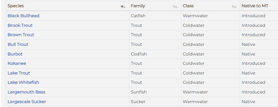
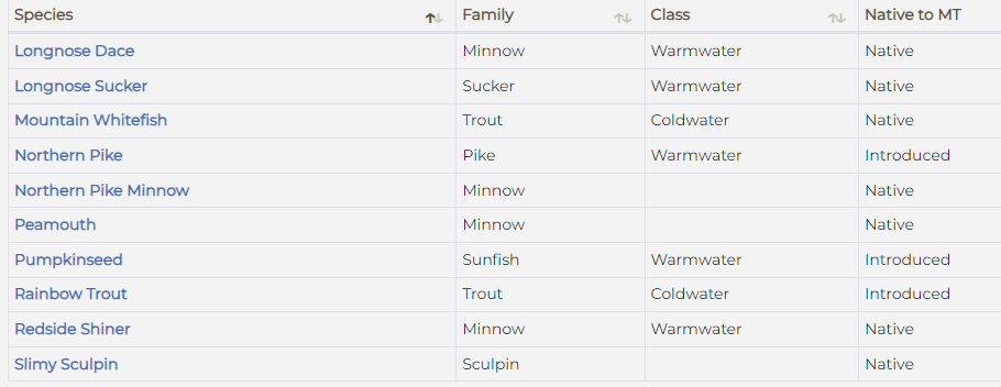
Native species. Almost every reservoir construction is associated with invasive species. This is what FWP lists for Noxon
1689798981818.png
1689799004783.png
1689799026935.png
 
I'll provide a couple counter points that I'm sure you already made to your friend.

Walk along it. Rivers fluctuate, there is a high flow and low flow, and, at least in much of the west, you're allowed to walk between those two. Dam controlled reservoirs don't have this feature. Shorelines are often privately owned without access outside of a few boat ramps. Where can you pull over and have lunch, the boat ramp? Utility is still confined to a boat. Yes you can go anywhere, but you're restricted to your boat, not having an accessible shoreline is a loss.

You're only trading one form of McMansion for another, instead of ranchettes or actual ranches, you're left with 10x-100x the number of landside McMansions.

As Theat pointed out, you get a ton more noise pollution unless you restrict motorized access, but even then you're subject to just people noise, water carries much further across water than down/up a river.

Native species. Almost every reservoir construction is associated with invasive species. This is what FWP lists for Noxon
View attachment 284694
View attachment 284695
View attachment 284696

The majority of the money that the power company spends on habitat and mitigation is geared towards native trout species and particularly Bull Trout. Much of this is an effort to fend off Bull Trout being listed as endangered and the resulting regulatory impact that would have on their operations. They have done some pretty impressive projects up the creeks and rivers that flow into the reservoir to improve habitat and decrease sediment in the water primarily due to previous mining and logging activities. The work they are doing is great, but in my opinion it will have very little positive impact on the local Bull Trout populations. The long term trend in Bull Trout populations is not looking good here. Once the river was dammed, Bull trout were doomed. They spend the majority of their lives in the main river which is now a reservoir that has significantly higher water temps and is full of non native predator species. I've spent countless hours fishing the reservoir and other connected waters and have only once caught a Bull Trout anywhere and only 2 cutthroats in the reservoir. It is basically a warm water fishery at this point.

To your point about shoreline access, I was going to mention another one of my peeves about the dams in my previous post. When the original proposals for the Lower Clark Fork Dams were being hashed out, the state offered to use eminent domain to not only acquire all the lands that would be flooded, but also the vast majority of the new shoreline up to a certain elevation above full pool to entice Washington Water Power to commit to the project. So not only did a private company get all the now flooded lands for free, they also got many thousands of acres of non flooded land as well. Most of it is a thin 50-100 yard strip along the shoreline, but they also have several other quite large sections of flats along the reservoir. The current owner (Avista) leases much of the small strips to people such as myself that own abutting land and allows access on most of the rest either through the Block Management Program or their own access system. I do appreciate the way that they manage their property for public access, but it still rubs me wrong that they got it all for free from the state and Montana landowners to build dams that provide no electricity for Montanans.
 
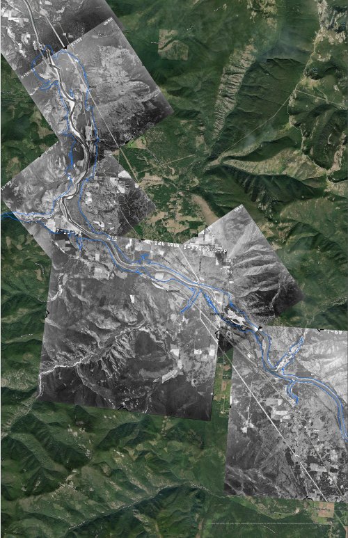
Theat's posts prompted me to do a little geeking out. Acquired a pile of 1952/53 aerial imagery of what is now under Noxon Reservoir - which was built in 1955 - and I built a map from them.

1952Compressed.jpg


The uncompressed file is huge, and the map is something like 22 x 36. You will really have to zoom in to see any detail, and if you want that uncompressed version to gander upon, you can do so via this link:

https://drive.google.com/file/d/1j86reSqGfjD1Oe5p4zil1QoazdIVUZI0/view?usp=drive_link

I included the current shoreline of Noxon Reservoir for reference. Kinda neat to see.
 
I'm new to this thread, but just this last weekend I attended the dedication of the FAS in Livingston newly-named after Jim Posewitz, wherein they showed @Big Fin's film and celebrated the life and legacy of not only the great and powerful Pos, but also the many people that fought to keep the Paradise Valley paradise.

Perhaps most striking was the commentary from the guest speakers that conservation stories are so often stories of things that DIDN'T happen, and the importance of carrying these stories forward is so incredibly important. It shouldn't be lost on younger generations that so much of what they get to enjoy is because of dams that never were, laws that were never implemented, and the work of people we will never know.

All this to say, keep it up @Nameless Range and everyone else here. The stories of things that didn't happen is why we get to keep creating stories of outdoor adventures that do happen.
 
Theat's posts prompted me to do a little geeking out. Acquired a pile of 1952/53 aerial imagery of what is now under Noxon Reservoir - which was built in 1955 - and I built a map from them.

View attachment 290084


The uncompressed file is huge, and the map is something like 22 x 36. You will really have to zoom in to see any detail, and if you want that uncompressed version to gander upon, you can do so via this link:

https://drive.google.com/file/d/1j86reSqGfjD1Oe5p4zil1QoazdIVUZI0/view?usp=drive_link

I included the current shoreline of Noxon Reservoir for reference. Kinda neat to see.

Thanks again for putting that together. Very cool to see what lies under the waters that I frequent so often.
 
HuntTalkers who are friends with me on The Facebook have already seen these, but a kick I have been on since Big Fin made the film The Dam That Never Was is mapping out the footprints of lakes that would have existed had proposed dams been built that never were.

Though some dams had better chances than others, in almost every case conservationists stood up for the land and the rivers and voiced opposition. Using data about the proposed dams heights and other information, we can use the contours of the land to infer the inundation areas.

I've got a pile more to do, and will post them here as I go. I think they make for interesting stories of conservation.

View attachment 146258
Very interesting Thread, OP. Thanks for sharing
 
I've been over this bridge many times, but never knew the history of it. Auburn SRA is one of the very few CA State Park properties that has hunting opportunities.


Latest posts

Forum statistics

Threads
113,659
Messages
2,028,776
Members
36,275
Latest member
johnw3474
Back
Top