Dams That Never Were

Stone_Ice_1, I grew up in Plains in the 60s too. The dam I remember proposed was the Knowles dam on the rez boundary. Just upstream from the Clark Fork bridge. It must have been the back up alternative for the Paradise dam.

In 75 I was evaluating the mineral deposits in Hells Canyon with a team. I believe 11 dams were proposed upstream of Lewiston, Idaho. Before we could finish our report for the Hells Canyon recreation area congress passed it to stop the dams. The joke in the office was that to work for the corps of engineers you had to hate the sound of running water.

I did quite a bit of research on the Knowles Dam. The Corps of Engineers had three sites on the Flathead they were considering other than Paradise: Knowles, Perma, and Oxbow. Paradise would have flooded all of those, so they determined it was the preferred alternative.
 
Wow. Great stuff. There was another dam Poz would tell me about that "never was." It was slated upstream from Fort Peck, flooding most of what is the river corridor that is now the core sheep hunting in 482 and parts of 680. I can't remember the name he gave it, but he had a long story of how that one got shelved, also. If you are researching, I would be interested if you can find anything on that one.
 
I think some of the creeks on the West side of the Bitterroot (Blodgett, etc.) were on some sort of list to be dammed too.

IRRC, it was most recently being considered under the Reagan Administration.
 
Great Research project.

Stone_Ice_1, I grew up in Plains in the 60s too. The dam I remember proposed was the Knowles dam on the rez boundary. Just upstream from the Clark Fork bridge. It must have been the back up alternative for the Paradise dam.

In 75 I was evaluating the mineral deposits in Hells Canyon with a team. I believe 11 dams were proposed upstream of Lewiston, Idaho. Before we could finish our report for the Hells Canyon recreation area congress passed it to stop the dams. The joke in the office was that to work for the corps of engineers you had to hate the sound of running water.
Before the multiple dam proposal in Hell's Canyon, there was also an attempt to put one large dam below the confluence of the Salmon and Snake.

There are others in Idaho as well, Including two attempts to dam the upper Middle Fork of the Clearwater. The first known as the "Kooskia Dam Project", and a later attempt known as the "Penny Cliff's Project"

The Penny Cliffs project was paired with the what is now known as Dworshak Dam. Opponents had lost the fight to prevent it, but at the last minute the House Committee on Public Works killed it because of the expense to relocate the newly finished US 12 Lolo Pass highway.
 
Dang, that would be a huge loss of winter range. People always debate the impacts on fish and animals that depend on the river, but rarely have I heard the issue of habitat loss for deer and elk raised. I can’t imagine what impact it would have on deer and elk if the entire Paradise Valley was under water!
It played out in Colorado with the Blue Mesa Dam finished in 1966. It is the uppermost of three dams on the upper Gunnison River that comprise the Aspinall Unit of the Colorado River Storage Project. It submerged over 9,000 acres of mule deer and elk winter range, as well as a significant portion of the overall range of the now endangered Gunnison Sage-Grouse.
 
I have a friend that was an engineer for the corps and managed the ones on the upper snake below Lewiston. He said the plan (70s) was to build a smaller dam below each of the peak power units as a regulating dam that would have a steady flow discharge. It used to be a real challege in trapping. You would set the trap correctly but when you returned it could be in 5-6 ft of water or on a mud flats.
 
I've also kind of engaged in the reverse. What sorts of heavens have we already buried under water? I think if you polled the sportsmen of Helena, MT about Canyon Ferry Lake, and gave them the magical choice of removing the dam and restoring that 20 mile braided bottomland that most certainly was a whitetail hunter's paradise, most would say they prefer the lake. Would we say the same things about these reservoirs had their dams been built? Reservoirs certainly offer some things that untamed rivers do not.

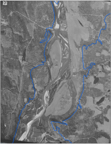
Here's a 1962 image of the Kootenai River just west of Rexford. The islands and river bottoms now out of reach, the blue line being the current shores of lake Koocanusa.

From this Missoulian article: https://missoulian.com/news/state-a...N4DmbYg24jo7dlS7xsan3Uwp9q4i5TYQMmG5W3-UaXIZg


"It had everything you'd want," Peterson said. "Fishing, recreation, solitude. Some years it'd flood out and jam with big ice floes. There were big islands, some with farms on them."
"There was a terrible, terrible sense of loss," Jim Morey said of the days when Libby Dam first plugged the Kootenai River Valley.....That river was the prettiest crystal blue-green in the whole world; and that dam was about the ugliest thing you ever saw. I called it the concrete monster."
"Oh, that was just a beautiful river," Marvel said. "Right about Rexford, that's where it started to open up out of the canyon. The fall was the best, catching big old trout. It was better fishing than this damn reservoir ever will be.

1594394261881.png
 
This is extremely interesting stuff (especially the visuals), Nameless - thanks for sharing.

The big one here locally (was a few years before I moved here) was Two Forks at the confluence of the South fork of the Platte. It would have flooded the canyon from Nighthawk to Deckers, wiping out 20 miles of Gold Medal fishing and leaving only a few miles of moving water between Cheesman's outlet and Deckers (half of which is seriously private). From an anglers perspective - that would have been armageddon. Not to mention villages (hard to call them 'towns') and homes wiped off the map, new roads cut into the ponderosa forest, deer/elk/turkey/lion habitat loss, etc, etc. There are still 'All this will be Under Water' protest signs along the river to this day.

Fair summary here on the impact the veto had on our water management approaches - the build dam, rinse, repeat model pivoted as a result: https://www.watereducationcolorado.org/publications-and-radio/radio/the-fork-not-taken/
 
I've also kind of engaged in the reverse. What sorts of heavens have we already buried under water? I think if you polled the sportsmen of Helena, MT about Canyon Ferry Lake, and gave them the magical choice of removing the dam and restoring that 20 mile braided bottomland that most certainly was a whitetail hunter's paradise, most would say they prefer the lake. Would we say the same things about these reservoirs had their dams been built? Reservoirs certainly offer some things that untamed rivers do not.

Here's a 1962 image of the Kootenai River just west of Rexford. The islands and river bottoms now out of reach, the blue line being the current shores of lake Koocanusa.

From this Missoulian article: https://missoulian.com/news/state-a...N4DmbYg24jo7dlS7xsan3Uwp9q4i5TYQMmG5W3-UaXIZg


"It had everything you'd want," Peterson said. "Fishing, recreation, solitude. Some years it'd flood out and jam with big ice floes. There were big islands, some with farms on them."
"There was a terrible, terrible sense of loss," Jim Morey said of the days when Libby Dam first plugged the Kootenai River Valley.....That river was the prettiest crystal blue-green in the whole world; and that dam was about the ugliest thing you ever saw. I called it the concrete monster."
"Oh, that was just a beautiful river," Marvel said. "Right about Rexford, that's where it started to open up out of the canyon. The fall was the best, catching big old trout. It was better fishing than this damn reservoir ever will be.

View attachment 146336

That thing had to wintering deer, elk, and moose at the least.
 
It played out in Colorado with the Blue Mesa Dam finished in 1966. It is the uppermost of three dams on the upper Gunnison River that comprise the Aspinall Unit of the Colorado River Storage Project. It submerged over 9,000 acres of mule deer and elk winter range, as well as a significant portion of the overall range of the now endangered Gunnison Sage-Grouse.
Here's a pretty good article from the 2018 drought year about what was submerged by Blue Mesa.

 
How about dams the used to be?
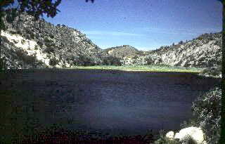
This was the small lake at Beaver dam state park near Pioche NV. After the dam was removed there is now only a small brush choked stream. It is fishable but the lake was nice too. It is very much off the beaten path and required a long drive over dirt road so it was not over run with people.

beaverdam.jpgoak-knoll-trail2.jpg
 
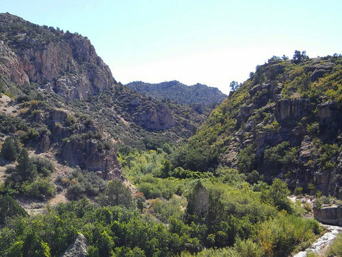
Here's another dam that once was.

 
Use Promo Code Randy for 20% off OutdoorClass

Latest posts

Forum statistics

Threads
113,568
Messages
2,025,391
Members
36,235
Latest member
Camillelynn
Back
Top