CO Unit 18

Wis_sharpshooter

New member
Joined
Nov 14, 2017
Messages
16
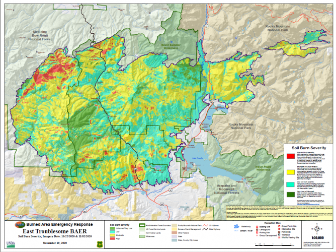
Hey everyone, I have the title of new member but I’ve actually been a member since 2017, I just do much more listening than talking! I have a CO Unit 18 1st season elk rifle tag. I know a lot of that unit burnt last year, looking over maps form onX and go hunt, Google, it still shows timbered areas, does anyone have a spot to find new aerials that show the actual burned areas? Thanks
 
Try Gaia gps maps, they have recent sat. photos. I’ve looked the area over. It’s pretty brown and burned. Gaia gives a free 2 week trial too I think.
 
Those burn perimeters should be in the wildfire data set by now as well. That’ll help you regardless of the date of the satellite imagery
 
I also considered putting in for secondary draw unit 18 muzzleloader tags. The reports I have read said there was a minimal amount of animals that died in fire and I think I read the herd is at objective. I just find it hard to believe that there was not many animals that died when the fire moved across the mountains so fast. Thoughts?
 
i dunno. cpw tends to be pretty confident in what they say when animals are pretty capable of fending for themselves in even fast moving fires.

go look up the video by cpw on collared cow elk during the cameron peak fire last year. they found many of the cows would move away from the fire perimeter but still stay in the area and often were moving in and out of the active burn area. this was also a hot hot fast fire.

Thanks Togie! I will look that up. I turned back in a tag last year because of the Cameron peak fire.
 
Just keep in mind that a lot of timber still has canopy needles but was severely scorched and these will pretty much all die in my experience. Lots of the eastern portion is nothing but vertical black sticks without even any burnt horizontal limbs. This was during the 70 mph wind days really got her cooking good.

As per the animals getting out of the way they barely got the people out with police escorts and cars, something tells me the CPW was not escorting elk up and over into north park, but as I wasn't there they probably were doing just that... And they must have given them the "stay" command cause winter range had virtually nothing on it last winter, no animals and no tracks.

CPW told me the reason there was nothing on the winter range is cause after the storm put out the fire the grass greened up so good that they just wintered in place, eliminating the need to migrate at all. Funny as I was camping on the back end of that storm and it was -5 and we were forbidden to have a camp stove. They must have seeded it with a "northern mix" of grass that sprouts well in sub zero weather. After he told me this with a straight ace I asked if he thought we should go up and bale some of it as hay was pressing $400/ton and it was senseless to let all that green go to waste feeding stupid elk.

I would not count on the fact tags are being sold as definitive proof that there will be animals there to hunt. 6000 acres/hour is an incredible incineration rate, they will be studying that one for decades. How many "forest fires" burn over treeless tundra till they hit fuel on the other side?? Unreal conditions.
 
Hey everyone, I have the title of new member but I’ve actually been a member since 2017, I just do much more listening than talking! I have a CO Unit 18 1st season elk rifle tag. I know a lot of that unit burnt last year, looking over maps form onX and go hunt, Google, it still shows timbered areas, does anyone have a spot to find new aerials that show the actual burned areas? Thanks
The west border 181 and 18 is main fork Troublesome creek. I was up hunting 18 last year and filled my elk tag and left mid day on wed. I was on east side elk mt and drove down to Hwy 125. I drove back up in Mar and they don't open gate till first of june.

I could see south face elk mt no damage then when north on rd that borders Troublesome Cr and look like some fire damage high ridge start of Troublesome basin. That rd goes from 40 over to hwy125 gate was close but those ranches nothing burned. We drove in to park and lot burned. I'm going to hunt 18 this year 2nd rifle season bull tag.
Thanks for the info
 
Ive heard this unit is open now, can anybody confirm? The Hunting Atlas still shows it closed?
 
Its a damn shame what happened with those fires. I found some great spots in that unit for archery season last year and was covered up in elk.
 
Gastro Gnome - Eat Better Wherever

Latest posts

Forum statistics

Threads
114,010
Messages
2,041,042
Members
36,429
Latest member
Dusky
Back
Top