Ask your onX Hunt questions here!

Not sure if this has been asked already. Why does my onX show the corners roughly 3 feet +or- from the actual land markers??
As mentioned by some other folks, there are a few things at work here. First, your phone GPS is not going to be accurate down to the inch, getting within a couple of feet is typical performance from today's smartphones and standalone GPS devices. Additionally, the parcel boundaries that we receive from local county tax assessors are not survey quality. When we acquire that data, it usually comes with a disclaimer from the county that the lines within the data set can be off by as much as 50 feet. We, of course, find the lines to be much more accurate than that in most cases. Our data can only be as good as the data we receive from the county, so if that is off a few feet, our lines will be off a few feet as well. When in doubt, your survey markers are what you should go with.
 
Not sure if this has been asked already. Why does my onX show the corners roughly 3 feet +or- from the actual land markers??
Survey equipment needs to work with GPS as well as radio towers and different receivers/ transponders to get as accurate as they do.

Much like aircraft do.
 
Not sure if this has been asked already. Why does my onX show the corners roughly 3 feet +or- from the actual land markers??
If you're basing the location off of the air photo that is another source of error. Air photos are georeferenced which introduces a certain amount of error along with any parcel mapping inconsistencies. How the property was surveyed has a lot to do with it as well.
 
Have a question on editing multiple waypoints at once on desktop version. I know how you can 'select all' waypoints visible on the screen, but is there a way to apply the same edits to all of those once you select them? For example, I have numerous glassing locations marked in Google Earth and I've imported a .kml into OnX. When I do so all of these waypoints come in with the generic red X icon. Is there a way to turn them all a different color and different symbol all at one time without going through each waypoint 1 by 1? Thanks.
 
As mentioned by some other folks, there are a few things at work here. First, your phone GPS is not going to be accurate down to the inch, getting within a couple of feet is typical performance from today's smartphones and standalone GPS devices. Additionally, the parcel boundaries that we receive from local county tax assessors are not survey quality. When we acquire that data, it usually comes with a disclaimer from the county that the lines within the data set can be off by as much as 50 feet. We, of course, find the lines to be much more accurate than that in most cases. Our data can only be as good as the data we receive from the county, so if that is off a few feet, our lines will be off a few feet as well. When in doubt, your survey markers are what you should go with.
I’ve seen/heard a claim that you guys guarantee your markers down to <10 ft.
Is this not true?
I’m not gonna lie, I’ve tried to test it multiple occasions and it’s usually DAMN close to right on the money…
 
Anyone ever have issues with the indicator not point at what you’re aiming your phone at. Example the new rangefinder feature? I’m thinking it’s more of an issue with my iPhone but just curious if anyone else has had that issue.
 
I tried to use the onX off road app on my phone with the free 7 day trial. It kept freezing up but I blame my phone because it's a cheapo smart phone.
My question is whether I could buy the onX Hunt app for my laptop and download maps to my phone?
I'd really like to see where the sheep watering devices are in my hunt unit.
What phone are you using?
Have you tried the regular version of onX instead of the off road?
 
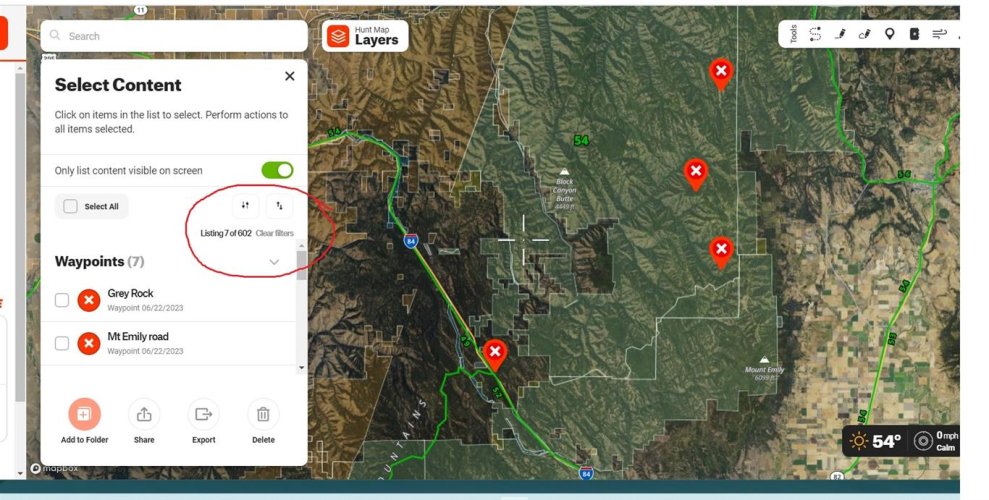
Have a question on editing multiple waypoints at once on desktop version. I know how you can 'select all' waypoints visible on the screen, but is there a way to apply the same edits to all of those once you select them? For example, I have numerous glassing locations marked in Google Earth and I've imported a .kml into OnX. When I do so all of these waypoints come in with the generic red X icon. Is there a way to turn them all a different color and different symbol all at one time without going through each waypoint 1 by 1? Thanks.

"select all" in conjunction with the "only list visible" toggled ON, selects all data within the bounds of the screen, visible and hidden. The "only list visible" toggle has never worked, all data within the screen boundary is listed.

Untitled (Medium) (2).jpg

You can select multiple pieces of data from the "my content"/select tick box but you can't edit the selected group.
 
I’ve seen/heard a claim that you guys guarantee your markers down to <10 ft.
Is this not true?
I’m not gonna lie, I’ve tried to test it multiple occasions and it’s usually DAMN close to right on the money…
We do not guarantee that the markers are accurate to <10 feet. There really is no way for us to ensure that our data is that accurate when we get it from the source. If the source data is not accurate to within 10 feet, there is no way for us to make it more accurate. That being said, we generally find that the parcel lines we have are within that 10-15 feet range, but there can be some that are farther than that in rare occasions.
 
Have a question on editing multiple waypoints at once on desktop version. I know how you can 'select all' waypoints visible on the screen, but is there a way to apply the same edits to all of those once you select them? For example, I have numerous glassing locations marked in Google Earth and I've imported a .kml into OnX. When I do so all of these waypoints come in with the generic red X icon. Is there a way to turn them all a different color and different symbol all at one time without going through each waypoint 1 by 1? Thanks.
Unfortunately, we do not have the ability to do a bulk edit of markups at this time. I can definitely see how useful that feature could be, so I'll definitely mention out to our engineering teams.
 
Anyone ever have issues with the indicator not point at what you’re aiming your phone at. Example the new rangefinder feature? I’m thinking it’s more of an issue with my iPhone but just curious if anyone else has had that issue.
This is most likely an issue with the compass on your phone. First thing to do is check your compass app on phone. That should match what you are seeing in onX. If the compass on your phone is off, you can try calibrating it. To calibrate your compass on an iPhone, open Settings> Privacy & Security> Location Services> System Services> Compass Calibration. Turn that Calibration switch off and on (Sometimes you may need to toggle it a few times) Then double check your compass on your phone. If it is still not accurate, that indicates there is a larger problem with the internal compass on your phone.
 
I tried to use the onX off road app on my phone with the free 7 day trial. It kept freezing up but I blame my phone because it's a cheapo smart phone.
My question is whether I could buy the onX Hunt app for my laptop and download maps to my phone?
I'd really like to see where the sheep watering devices are in my hunt unit.
Buying onX Hunt on your laptop is not really any different than buying it on your phone. If your phone is unable to run the App, it does not matter where the membership was purchased. Our recommendation is to download the Hunt App and start a free trial on your phone. That will give you a good indication of whether or not your particular phone model is capable of running the onX Hunt App.
 
Buying onX Hunt on your laptop is not really any different than buying it on your phone. If your phone is unable to run the App, it does not matter where the membership was purchased. Our recommendation is to download the Hunt App and start a free trial on your phone. That will give you a good indication of whether or not your particular phone model is capable of running the onX Hunt App.
Thanks I'll give that a try.
 
Has something changed where now the 3D map is only available with Elite?

I have a premium subscription.
This morning I could use the 3D viewing function, this afternoon it is saying it’s locked and I need to upgrade to use that feature???
 
@onX Hunt How do i remove the weather button that almost always tells me wrong wing and direction. If i hit it by accident it zooms me way out and then takes significant time to get back to what i was looking at. Dont even want weather option, how do i turn it off its a PIA for me and my gloved hands.
 
Anyone know why my phone seems to think I'm not an elite member anymore, even though logging in on my laptop confirms that I am..?

I realized when I went to download an offline map on my phone and it wouldn't let me. I could do it on the laptop though.
 
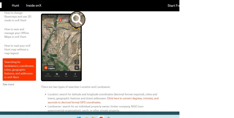
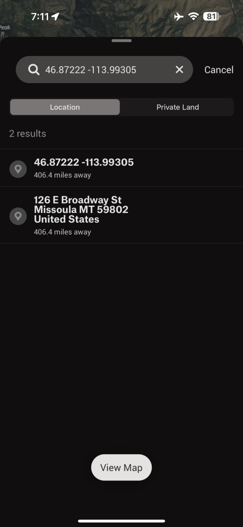
how do you manually enter coordinates for a waypoint in the app. examope, a guy sends a coordinate to me via inreach and not I need to create a waypoint at that coordination ate to navigate. Now cell signal in this scenario.

thx..
 
how do you manually enter coordinates for a waypoint in the app. examope, a guy sends a coordinate to me via inreach and not I need to create a waypoint at that coordination ate to navigate. Now cell signal in this scenario.

thx..

Search(upper right corner icon on home screen) / location
Input needs to be decimal deg.

Untitled.jpg

IMG_0220.png
 
Yeti GOBOX Collection

Forum statistics

Threads
114,009
Messages
2,041,030
Members
36,429
Latest member
Dusky
Back
Top