Kenetrek Boots

Ask your onX Hunt questions here!

Working flawlessly for me, have not installed latest update.
iPhone 5 and latest iOS.
Had to turn off auto lock to get maps to fully download. Tracking is working well. Waypoints way too big. Waiting on import of kmz as I have multiple geo referenced raster conversions I use.
Looking good so far, well done.
 
I went out scouting this past weekend with hopes of marking a few places and could not get the app to work offline. The app kept crashing every time I switched to airplane mode or while in the app switching to "offline" under one of the menu settings. I just got home and got on here to see that they had an update. I updated the app and now it seems to be working and not crashing. This makes me a little nervous since I will be going on my first elk hunt in 2 days. I will have real maps as backups just in case!
 
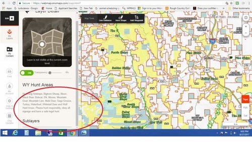
Anyone use OnX on their computer? I just logged in for the first time in a while since I normally use my iOS devices. I tried selecting a sublayer within a layer (WY hunt unit) and it doest allow me to scroll down far enough to select the sublayers. Am I doing something wrong?

OnX Screen Shot.jpg
 
Last edited:
Are layers supposed to work on saved maps? I can open the layers tab but when i turn layers on and off, The saved map layers do not change.

I have the same issue. Made it impossible to see the satellite view.

it doest allow me to scroll down far enough to select the sublayers.

Same issue here. I had use the browser sizing to switch to pronghorn layers (ctrl minus)
 
Track distance not shown on the content page once saved; need to go to track edit to see the distance then the text is dark grey on a black background.
 
Iphone 5s IOS ver. 10.3.3 app ver4.0.3

I just updated Iphone app from 4.0.2 to 4.0.3 and It fixed my offline crashing. I did clear and re-download my offlline maps. Noticed that you want to have your layer settings exactly how you want them before download. This kinda sucks because if you have the state land overlay it sort of makes it hard to see details on the satellite view. I'll take what I can get at this point. Glad to see ONX is working out the bugs rather quickly.
 
I have the same issue. Made it impossible to see the satellite view.


Same issue here. I had use the browser sizing to switch to pronghorn layers (ctrl minus)

Thanks for that, I rarely use it on the computer so I wasnt sure how to see the sublayers. I'm saving my offline maps with just the private parcels and assuming every thing outside of that is public. Not ideal but its the best I can do considering my second hunt this year is in 14 days.
 
Sage grouse distriubution does not seem to work on webapp.

Also, option to download entire state of: BMA, HD, or Private landownership?
 
The app crashes every time when trying to used saved maps in airplane mode on my Iphone 7.

Make sure you have the most updated version of the App. We are continually releasing updates that will alleviate crashes you are experiencing.
 
Is this app usable on an apple watch? At one point in time, i've seen links to using it on an apple watch.. but was wondering if maybe that was false or just hasn't been released with the new update? Would be cool to be able to put down a waypoint quickly with a watch.

Also, when are you guys expected to release photo waypoints back into the system? I'm running out of unique names for my waypoints and blinds :)

For the time being, the Hunt Membership is only available for smart phone, tablet, and computer.

We have not forgot about photo waypoints. It is on our product road map, however we do not have a specific date at this time.
 
I starting looking at ONX this summer. The premise is outstanding and seems like the original product had a lot of fans. My experience has only been toying with the new platform and that has some gaps that need to be filled for my to buy. It looks like progress on some fronts but haven't seen that all have been solved.

For me, here is the essential "fix" list:

1. Rock solid stability of offline maps on the iPhone. Sounds like it has improved with latest build but would be interested in updates from actual users.

2. Importing existing waypoints/tracks and ability to export back out (I don't do vendor lock down of my data). Sounds like this is on the horizon. Any sense if it will make this hunting season or is that for next season?

3. The ability to turn layers on and off in offline mode. I fear that the new platform "flattens" your chosen layers when syncing to phone so layer by layer selection is not just a missing feature but incompatible with the offline framework. If this is not the case it would be great to hear that layer by layer optionality will be present in future builds. And if so, this season or next?

Hope this get fully resolved, as I would like to be a customer.
 
OnXmaps is taking up 4.78GB on iCloud. Does that sound correct?

Edit - After talking with support this is probably the maps. They take up a lot of space.
 
Last edited:
I just wanted to make sure I understand the offline maps correctly so it is ready to go when I go out. These are all for an Android phone if that matters.

1. With the new map offline map when you save an area it automatically saves all 3 base maps correct?

2. Does it save all of the optional layers like GMUs & Private land or do you still need to turn those on before you save the map?

3. If you duplicate an area you have saved offline (say you have a corner area between two 5 mile zones overlapping) does it use space as if they are two seperate maps or does it detect you already have that area saved and not save it again?

4. Any plans to allow saving maps to an SD card? It would be nice to be able to use my 256gb card instead of my 32 gb internal storage

Thanks
 
Anybody else have issues searching landowner names? Nobody I search pulls up anything. I've looked at a name on the map and entered it into the search page exactly as it's spelled and still turns up nothing. I've tried First Last and Last, First and neither works.
 
Approx. how many high quality resolution maps (5 sq miles) are you able to load on iPhone with 40gb of space left? Debating on whether or not to save the maps in high resolution but I may need a handful of maps to cover the area and can get by with just a couple in medium resolution.
 
Vikings Guy

1. Rock solid stability of offline maps on the iPhone. Sounds like it has improved with latest build but would be interested in updates from actual users. Yes we had another great release Monday for iPhone and have another one planned this week as well. This has been the top priority and will probably always be with all of the features we have that we want to do with saved maps in the future as well.

2. Importing existing waypoints/tracks and ability to export back out (I don't do vendor lock down of my data). Sounds like this is on the horizon. Any sense if it will make this hunting season or is that for next season? The web map team is working on it right now. We are testing it currently so it is close to release and will definitely be out for this season.

3. The ability to turn layers on and off in offline mode. I fear that the new platform "flattens" your chosen layers when syncing to phone so layer by layer selection is not just a missing feature but incompatible with the offline framework. If this is not the case it would be great to hear that layer by layer optionality will be present in future builds. And if so, this season or next? The Android version we are testing today for release any day now has the ability to turn layers on/off and change transparancy while in offline mode. The team has already move on to this feature in iOS and it will be released as soon as they are ready.


RobG, Each saved map could be around 200-500 MB so that means you have a lot of maps saved it looks like. I usually try to minimize how many saved maps I have and remove unneeded ones after a hunt. Be sure you have the newest version installed from the app store as well.

Gazelle

1. With the new map offline map when you save an area it automatically saves all 3 base maps correct? Yes

2. Does it save all of the optional layers like GMUs & Private land or do you still need to turn those on before you save the map? It saves the layers you have on. Some 3rd party layers can't be saved like Radar, boat ramps for example. Best practice is to only have on the layers you will need when offline when saving a map.

3. If you duplicate an area you have saved offline (say you have a corner area between two 5 mile zones overlapping) does it use space as if they are two seperate maps or does it detect you already have that area saved and not save it again? It will not detect you already have a saved map, It basically takes a snap shot of the area you select so at this point try not to overlap boxes if you are worried about space.

4. Any plans to allow saving maps to an SD card? It would be nice to be able to use my 256gb card instead of my 32 gb internal storage We have discussed it but it is not being worked on at this time due to other priorities for offline maps
 
The offline Iphone maps have been solid from day one for me.

I have a need to create tracks in the web map or pick individual roads and change the color (vehicle vs bike roads), then sync with the app. Is this coming or available to test (leaving for 10 days on thursday)?
 
Leupold BX-4 Rangefinding Binoculars

Forum statistics

Threads
114,025
Messages
2,041,641
Members
36,433
Latest member
x_ring2000
Back
Top