Ask your onX Hunt questions here!

Did you try clicking on a state and then a species in the popup?
For example, clicking on Colorado > Elk > "Continue to CO Elk" takes you to filtering tool for most recent CO elk draw odds: https://copeakodds.shinyapps.io/coelk/
Other states/species work correspondingly similar
I guess my point was it looks like all the other services. In this case I don’t know what year data set it is using because I don’t see it anywhere. The only benefit to this is it’s free.
 
In the meanwhile, while you're waiting for onX why not just use PeakOdds. Only three states out there right now for deer, elk, and antelope but it doesn't cost anything---at least not yet.

Maybe I’m dumb but it’s only showing me a handful of Wyoming elk units and lists them all as having 100% draw odds
 
Maybe I’m dumb but it’s only showing me a handful of Wyoming elk units and lists them all as having 100% draw odds
You're not dumb at all....I'm guessing those are probably all the units you can draw with 100% odds as a resident? Try messing around with some of the switches and dials on the left and you will see things change (e.g. as you lower the draw odds since there are more units with lower draw odds esp. in random draw)
 
I wasted 2 minutes of my life on that site.

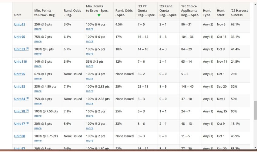
I can look at toprut and see where I should apply in 15 seconds. WY, NM, and AZ have been updated to show '23 odds.

View attachment 311561

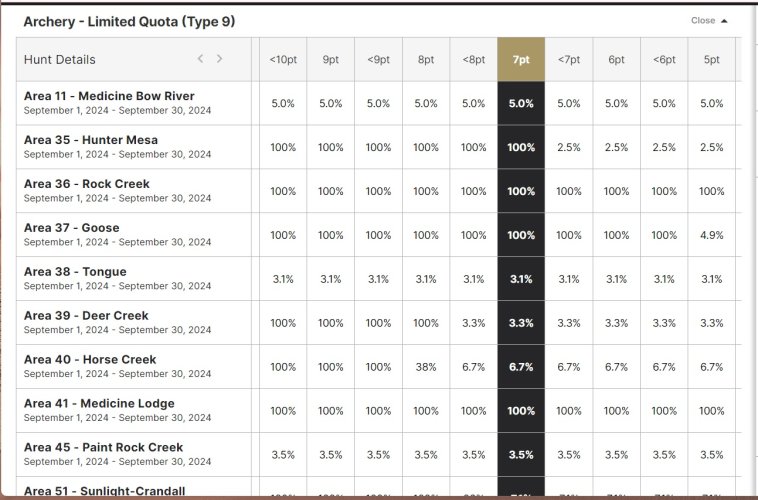
GoHunt is similar

View attachment 311562
Both are basically just pivot tables. Makes it easy to cut the data. The user just has to determine how much that is worth to them in $.
When you asked for historical draw odds, is that so you can see a trend and imply how it may look in the next draw?
 
Yes, but in an easier and faster format than I have now. I convert the pdf's to spreadsheets, go back a few years and see what past years were like for the hunts I think I can draw. GoHunt has a trend line for that purpose but I need to see the actual applicants in each point pool. Toprut shows those when you click the "more" link next to the "points required".
 
I went to trim a track today, and the app said I couldn’t trim unless I upgraded my account. Any insight here??
54496424-17F0-442C-9F3B-EEC8BCF38193.jpeg
 
I went to trim a track today, and the app said I couldn’t trim unless I upgraded my account. Any insight here??
View attachment 312801
Like Jbotto said, first try updating your app if there is an update available. If the issue persists after that, please send an email to our customer support team at [email protected]. That will allow us to dig in a little deeper and get everything up and running for you.
 
My issue that probably doesn't affect many.

I have two accounts. The one I use for work is handy if I notice, for example, livestock that may be in trespass. Easy enough to make a point and forward it to my range specialist. My issue is that I don't want this random pin stuck on my map. I thought I could just delete it after sending, but then it doesn't show up to whomever I sent it to. They have to accept it to their map before I delete it on my end.

I could just send them a lat/long, but that isn't very efficient. Or I could just leave the pin on my map, but I don't want to dilute my important stuff with locations of bad cows. ;)

Anyway this can be resolved? Something I am missing?
The best option, for this specific use case, is to either send them the lat-long coordinates so that they can add their own waypoint on their end, or if you send them a waypoint, have them manually add their own right on the same spot so that they still have a waypoint once you delete yours on your account.
 
I have a Samsung/Android phone, always battling memory issues. Is there a way to run the app from the SD card (some apps can do this), or at least store data to the card?
 
GOHUNT Insider

Latest posts

Forum statistics

Threads
114,023
Messages
2,041,589
Members
36,433
Latest member
x_ring2000
Back
Top