Navigation
Install the app
How to install the app on iOS
Follow along with the video below to see how to install our site as a web app on your home screen.
Note: This feature may not be available in some browsers.
More options
You are using an out of date browser. It may not display this or other websites correctly.
You should upgrade or use an alternative browser.
You should upgrade or use an alternative browser.
What type of survey marker?
- Thread starter jryoung
- Start date
Mallardsx2
Well-known member
- Joined
- Apr 4, 2015
- Messages
- 2,722
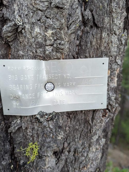
I would say that is a bearing tag for either an aerial survey target for a big game study or it is just a tag marking the edge of a study corridor. The other side of the study is 1254 feet away.
Kaitum
Well-known member
One piece of the puzzle: R5 - 2600 -13 refers to Region 5 (ie California) of the Forest Service. 2600 is the file code for all things Wildlife and Fisheries with USFS. Not sure what the 13 references, might be a Forest identifier.
Transect lines are a way of estimation animal populations. This sign is probably one end of a transect line that runs south for 19 chains. The researcher would follow that line and count any sign of the animals being studied. They would count sign along that line (droppings, rubs etc.) in order to estimate the population.
At least that is my understanding of big game transect lines. Hunting Wife would probably be the authority on this.
At least that is my understanding of big game transect lines. Hunting Wife would probably be the authority on this.
Salmonchaser
Well-known member
- Joined
- Nov 12, 2019
- Messages
- 2,433
Catherine said she has hung signs like that all over the Umatilla and Wallowa Whitman national forests. 1985 was probably a decade before first gen GPS was available so this was a method of being able to find a study area and return at some future date and Survey the area again.


