What if Ron Marcoux had not left MT FWP and went to work for RMEF? What if Alex Diekmann had not left his Wall Street career to work for the The Trust for Public Land (TPL). What if a lot of MT FWP old timers had not given the finger to the legislature and supported so many land deals? What if Bob Gibson had not been the Supervisor of Gallatin National Forest and a passionate elk hunter? What if Bob Denee had not been the Region 1 USFS Lands Program Director? What if (insert others who made a huge difference in land conservation in my back yard)?
We are starting some short films about the amazing work so many people did in our backyard that I am sure most folks today take for granted. These are key people, a list too long to name here, that made a huge difference; in essence, the right people in the right place, at the right time. And the product of their work is at risk of being taken for granted.
The list of projects in the northern Yellowstone area is very long - North Crazies, South Cottonwood, Porcupine, Taylor's Fork, Gallatin Consolidation, Madison Range consolidation, Upper Madison Valley, OTO, Dailey Lake/Dome Mountain, Royal Teton, Rigler corridor, Duck Creek, Crystal Cross, Nelson acquisition, and the list goes on. Just those added 76,000 acres of formerly checkerboard private lands to the public estate, plus perfecting access to many times that amount of acreage that was being blocked off by those deeded sections.
Last year, prior to his passing, we were able to interview Bob Gibson. We spent this week filming some of the projects that were the pinnacle of Alex's accomplishments before he passed in 2016 at age 52. Next week I am interviewing some of the others who I watched do remarkable work that just seemed like the right thing to do at the time, and now given the price of lands and demands for exclusive access seem to be absolute genius.
Part of the reason for doing this now is due to Bob and Alex passing without getting their full stories recorded. The other reason is that my entire purpose for our platforms is "To promote self-guided public land hunting and create advocates for that cause." I feel the stories of these relatively unknown people and their amazing work needs to be told to those who think what they enjoy today was always as it is today. What they are enjoying today is the result of a lot of hard work by a lot of people who risked much of their professional careers and in some cases, friendships, to get these completed.
Hopefully those projects and the stories of how they happened will motivate others to do what they can to make a difference today. If nothing comes of our films, that is fine. Doing these will give me a ton of personal gratification to shine light on people who did so much and who I felt blessed to call friends and do what little I could to help them in their efforts.
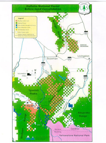
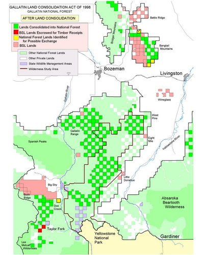
This map is just one of the many maps in my library of "before and after." onX and RMEF's creative team is helping me touch them up so they are less like crayons and more like a true digital image.
Below is what the Gallatin and Madison Ranges looked like before the many projects that were completed from 1992-2004. All that pink and some of that white was being closed once Big Sky Lumber bought the Plumb Creek Lands. Plumb Creek, the land holding division for lands (mostly checkerboard) acquired over 100 years prior via the railroad land grants, had always allowed public access. Once those lands were sold to BSL, BSL made it clear they did not intend to follow the Plumb Creek legacy. Not only were those lands to be closed, but so were the huge network of trails across those lands that took us deeper into the public lands.

Last edited:


