Sitka Gear Turkey Tool Belt

OnX is not always correct

davinski

Well-known member
Joined
Jan 30, 2011
Messages
362
Location
Western Colorado
PSA…OnX is not always correct. My buddies and I encountered a few other hunters this season who were not at all happy about us driving our atv’s on trails where we’ve driven them for years. Turns out the BLM still shows these routes open to motorized traffic, just like their latest Resource Management Plan and Travel Management Plan shows, but OnX lists them as closed. I definitely feel for those folks having hiked a long way and apparently planned most of their hunting and camp location around it. I didn't check OnX until after the conflict and that shed a little light on the situation. I'm only assuming that's what the other hunters were reading.

I highly recommend paper maps to verify open vs. closed if a person is going to hang their entire hunt plan around a specific route designation. The BLM in particular is not very user friendly. After the hunt, after confirming on my paper map and their public GIS, I called the Grand Junction office and talked through the location in question with the technician there. The tech also struggled with the GIS system on a 30 minute phone call but confirmed what I was reading.

I know there are many roads that have good reason to be closed, “use the quads God gave you,” all of that. I’m a BHA lifer. But if road is open, it’s open. I might suggest that a disgruntled walker doublecheck before they get bent about atv’s and cuss an old guy on a trail that’s obviously been ridden recently and has no closed signs anywhere. Something just might be up with the digital info. Or even, instead of cussing, engage in a little grownup conversation rather than assuming a rider is just another rule breaking a-hole and stomping off.

I’m fine with the a-hole part, but I follow the rules!
 
I hope this thread gets around because you are absolutely right, OnX is not 100% on everything. I have found that their system is fantastic for who the ground is deeded to, but possibly lacking in other areas. In some of the areas I hunt regularly in Colorado I have found that they have several roads marked as BLM roads, but they cross private lands making those sections of the road private. I also found one instance of a county road being mislabeled. When you are on the ground the actual county road is obvious but it could definitely mess up someone's plans when they show up and find that the BLM land this specific spot touches is not actually accessible.

Wonderful tool tool that I will use forever but I doubt they will testify for you in court...
 
They're wrong on state trust roads in MT as well. But to be fair, DNRC has a really scattered & crappy approach to roads on their lands. I've been pretty impressed with their layers in Michigan and Minnesota though.

Your GPS isn't infallible, but it's a damned good tool to have. Just like every other tool.
It’s as if MT DNRC takes all measures to be as unclear as possible on what you can drive.
 
PSA…OnX is not always correct. My buddies and I encountered a few other hunters this season who were not at all happy about us driving our atv’s on trails where we’ve driven them for years. Turns out the BLM still shows these routes open to motorized traffic, just like their latest Resource Management Plan and Travel Management Plan shows, but OnX lists them as closed. I definitely feel for those folks having hiked a long way and apparently planned most of their hunting and camp location around it. I didn't check OnX until after the conflict and that shed a little light on the situation. I'm only assuming that's what the other hunters were reading.

I highly recommend paper maps to verify open vs. closed if a person is going to hang their entire hunt plan around a specific route designation. The BLM in particular is not very user friendly. After the hunt, after confirming on my paper map and their public GIS, I called the Grand Junction office and talked through the location in question with the technician there. The tech also struggled with the GIS system on a 30 minute phone call but confirmed what I was reading.

I know there are many roads that have good reason to be closed, “use the quads God gave you,” all of that. I’m a BHA lifer. But if road is open, it’s open. I might suggest that a disgruntled walker doublecheck before they get bent about atv’s and cuss an old guy on a trail that’s obviously been ridden recently and has no closed signs anywhere. Something just might be up with the digital info. Or even, instead of cussing, engage in a little grownup conversation rather than assuming a rider is just another rule breaking a-hole and stomping off.

I’m fine with the a-hole part, but I follow the rules!
What is PSA, GIS, and BHA???
 
I own a farm with multiple parcels and onX shows one of the parcels (approximately 90 acres) as the neighbor owns it.

Like the old saying goes “trust but verify”.
 
Garbage in, garbage out. OnX doesn't create the data, they package it.
Correct. Onx uses files that all available from public government websites.

With that said, what I don't get is why onx can't use the county road maps than the files they use. I've found the most reliable and dependable road tool is following the county issues road and road classification map. Any road that the county notes as "maintained" is always open to public use. Some counties will also have the blm and fs roads
 
It is a great tool but not perfect. We hunt the same parcel in NM every year and they are off a couple of hundred feet on property lines in that area.
 
Parcel data is their bread and butter and due to our tax collection system is generally pretty damn accurate (same with all the other mapping apps). Roads layers are inherently complex due to multiple ownerships and no direct fiduciary reasons for maintaining accurate mapping. Onx's layers were especially wrong on numerous occasion in MT this year, it's the one area they can improve the most (way more important than all the other "features" they've added).
 
I turned off the roads layer as it was both wrong in open status and actual location. They are going to struggle trying to label many blm and state areas open/closed as there is limited mapping data and basic rules are unless signed any 2 track is open. The NFS makes it essier for them but its crap in crap out! I can take the Salmon ID area MPV map and find 50 errors on it but the forest doesnt care to fix so now all that bad info is passed along for others to find the problems out for themselves. My bigest concern is onx shows landlocked roads open on public but the access is completely private, someone is going to get in trouble sooner or later trying to get there cause "the road is open". They will eventually get it right but biggest problem will be the goverment input and that will take YEARS to make accurate so i just turn off the layer, i would like to see a country road map layer using county data.
 
It’s as if MT DNRC takes all measures to be as unclear as possible on what you can drive.
I don’t understand why people struggle with MT DNRC roads. If it’s not specifically marked open it’s fricken closed. That dang simple. Complete opposite of BLM routes in MT where no travel plan is in place
 
It’s as if MT DNRC takes all measures to be as unclear as possible on what you can drive.

When we tried to get this bill through (It died in the committee of origin on a party line vote after we accepted all of the chairmans' amendments), we worked with DNRC directly to try and do something that made sense from their perspective.

That meant funding a staff person to go around to each DNRC office & hand inputing roads from their data. This is what happens when you starve agencies with a mandatory cost savings by eliminating needed positions so you can go home & tell the rubes you "shrunk gov't."

This effort would have cost the state $75,000 and had support from every ag group, timber, energy, ORV's, conservation & hunting group.
 
PSA…OnX is not always correct. My buddies and I encountered a few other hunters this season who were not at all happy about us driving our atv’s on trails where we’ve driven them for years. Turns out the BLM still shows these routes open to motorized traffic, just like their latest Resource Management Plan and Travel Management Plan shows, but OnX lists them as closed. I definitely feel for those folks having hiked a long way and apparently planned most of their hunting and camp location around it. I didn't check OnX until after the conflict and that shed a little light on the situation. I'm only assuming that's what the other hunters were reading.

I highly recommend paper maps to verify open vs. closed if a person is going to hang their entire hunt plan around a specific route designation. The BLM in particular is not very user friendly. After the hunt, after confirming on my paper map and their public GIS, I called the Grand Junction office and talked through the location in question with the technician there. The tech also struggled with the GIS system on a 30 minute phone call but confirmed what I was reading.

I know there are many roads that have good reason to be closed, “use the quads God gave you,” all of that. I’m a BHA lifer. But if road is open, it’s open. I might suggest that a disgruntled walker doublecheck before they get bent about atv’s and cuss an old guy on a trail that’s obviously been ridden recently and has no closed signs anywhere. Something just might be up with the digital info. Or even, instead of cussing, engage in a little grownup conversation rather than assuming a rider is just another rule breaking a-hole and stomping off.

I’m fine with the a-hole part, but I follow the rules!
For my Colorado hunt, a bigger problem was people not following the travel management plan. If White River NF hadn’t signed it closed than people were driving it. They could give a crap less what the paper map said or onyx. Found that out on 2 long walks to walk into hordes of utvs and atvs
 
Their property boundary lines can be off be several hundred feet. I think this is a problem with the data, not their software.
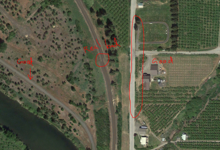
There's potentially 2 issues at play, the parcel lines being draw incorrectly, certainly possible based on the amount of effort the County has put into the data creation, or our perception that the aerial image is "correct" as opposed to the parcel lines. For those unaware, aerials are extremely inaccurate in that, if you see a specific thing (i.e. a tree, fence corner, etc.) in an aerial it's actual location in the world (lat/long) is likely incorrect. this is due to the complexities associated with camera lens distortion and fitting a round earth on a flat project (screen). We as humans see the fence on our phone or computer screen and assume it's "there" because we've learned to trust our eyesight to such a large degree, but you can find many many errors within an aerial photo.
1638374621442.png
 
Last edited:
I know the property lines are off as it shows that I have waterfront and the neighbors are in the lake. I give property line a wide birth just in case they are off there as well.
 
Advertisement

Forum statistics

Threads
113,671
Messages
2,029,155
Members
36,278
Latest member
votzemt
Back
Top